 Catalogue PIGMA
PML
Type of resources
Topics
Keywords
Contact for the resource
Provided by
Years
Formats
Representation types
status
Resolution
-
A Level 2P swath-based Group for High Resolution Sea Surface Temperature (GHRSST) dataset for the North Atlantic area from the Advanced Very High Resolution Radiometer (AVHRR) on the NOAA-19 platform (launched on 6 Feb 2009). This particular dataset is produced by the Natural Environment Research Council (NERC) Earth Observation Data Acquisition and Analysis Service (NEODAAS) in collaboration with the National Centre for Ocean Forecasting (NCOF) in the United Kingdom. The AVHRR is a space-borne scanning sensor on the National Oceanic and Atmospheric Administration (NOAA) family of Polar Orbiting Environmental Satellites (POES) having a operational legacy that traces back to the Television Infrared Observation Satellite-N (TIROS-N) launched in 1978. AVHRR instruments measure the radiance of the Earth in 5 (or 6) relatively wide spectral bands. The first two are centered around the red (0.6 micrometer) and near-infrared (0.9 micrometer) regions, the third one is located around 3.5 micrometer, and the last two sample the emitted thermal radiation, around 11 and 12 micrometers, respectively. The legacy 5 band instrument is known as AVHRR/2 while the more recent version, the AVHRR/3 (first carried on the NOAA-15 platform), acquires data in a 6th channel located at 1.6 micrometer. Typically the 11 and 12 micron channels are used to derive sea surface temperature (SST) sometimes in combination with the 3.5 micron channel. The highest ground resolution that can be obtained from the current AVHRR instruments is 1.1 km at nadir. The NOAA platforms are sun synchronous generally viewing the same earth location twice a day or more (latitude dependent) due to the relatively large AVHRR swath of approximately 2400 km. NEODAAS-Dundee acquires approximately 15 AVHRR direct broadcast High Resolution Picture Transmission (HRPT) passes per day over NW Europe and the Arctic. Each pass is approximately 15 minutes duration. These are immediately transferred to NEODAAS-Plymouth where they are processed into sea surface temperature (SST) products and converted to L2P specifications.
-
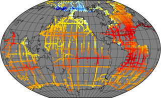
In recent years, large datasets of in situ marine carbonate system parameters (partial pressure of CO2 (pCO2), total alkalinity, dissolved inorganic carbon and pH) have been collated. These carbonate system datasets have highly variable data density in both space and time, especially in the case of pCO2, which is routinely measured at high frequency using underway measuring systems. This variation in data density can create biases when the data are used, for example for algorithm assessment, favouring datasets or regions with high data density. A common way to overcome data density issues is to bin the data into cells of equal latitude and longitude extent. This leads to bins with spatial areas that are latitude and projection dependent (eg become smaller and more elongated as the poles are approached). Additionally, as bin boundaries are defined without reference to the spatial distribution of the data or to geographical features, data clusters may be divided sub-optimally (eg a bin covering a region with a strong gradient). To overcome these problems and to provide a tool for matching in situ data with satellite, model and climatological data, which often have very different spatiotemporal scales both from the in situ data and from each other, a methodology has been created to group in situ data into ‘regions of interest’, spatiotemporal cylinders consisting of circles on the Earth’s surface extending over a period of time. These regions of interest are optimally adjusted to contain as many in situ measurements as possible. All in situ measurements of the same parameter contained in a region of interest are collated, including estimated uncertainties and regional summary statistics. The same grouping is done for each of the other datasets, producing a dataset of matchups. About 35 million in situ datapoints were then matched with data from five satellite sources and five model and re-analysis datasets to produce a global matchup dataset of carbonate system data, consisting of 287,000 regions of interest spanning 54 years from 1957 to 2020. Each region of interest is 100 km in diameter and 10 days in duration. An example application, the reparameterisation of a global total alkalinity algorithm, is shown. This matchup dataset can be updated as and when in situ and other datasets are updated, and similar datasets at finer spatiotemporal scale can be constructed, for example to enable regional studies. This dataset was funded by ESA Satellite Oceanographic Datasets for Acidification (OceanSODA) project which aims at developing the use of satellite Earth Observation for studying and monitoring marine carbonate chemistry. **This version is now superseded by the version 4 with higher spatial and temporal resolution**
-

In recent years, large datasets of in situ marine carbonate system parameters (partial pressure of CO2 (pCO2), total alkalinity, dissolved inorganic carbon and pH) have been collated. These carbonate system datasets have highly variable data density in both space and time, especially in the case of pCO2, which is routinely measured at high frequency using underway measuring systems. This variation in data density can create biases when the data are used, for example for algorithm assessment, favouring datasets or regions with high data density. A common way to overcome data density issues is to bin the data into cells of equal latitude and longitude extent. This leads to bins with spatial areas that are latitude and projection dependent (eg become smaller and more elongated as the poles are approached). Additionally, as bin boundaries are defined without reference to the spatial distribution of the data or to geographical features, data clusters may be divided sub-optimally (eg a bin covering a region with a strong gradient). To overcome these problems and to provide a tool for matching in situ data with satellite, model and climatological data, which often have very different spatiotemporal scales both from the in situ data and from each other, a methodology has been created to group in situ data into ‘regions of interest’, spatiotemporal cylinders consisting of circles on the Earth’s surface extending over a period of time. These regions of interest are optimally adjusted to contain as many in situ measurements as possible. All in situ measurements of the same parameter contained in a region of interest are collated, including estimated uncertainties and regional summary statistics. The same grouping is done for each of the other datasets, producing a dataset of matchups. About 35 million in situ datapoints were then matched with data from five satellite sources and five model and re-analysis datasets to produce a global matchup dataset of carbonate system data, consisting of 287,000 regions of interest spanning 54 years from 1957 to 2023. Each region of interest is 50 km in diameter and 5 days in duration, improving the spatial and temporal resolution of the previous version (v3.4). The list of sources added in this dataset includes: - sea surface temperature and sea ice concentration from Copernicus Climate Service Multi-satellite L4 (http://dx.doi.org/10.5285/62c0f97b1eac4e0197a674870afe1ee6) - sea surface salinity from the Copernicus Marine service Multi Observation Global Ocean Sea Surface Salinity and Sea Surface Density (https://doi.org/10.48670/moi-00051) - Surface ocean sea-air CO2 fluxes and total alkalinity from ETH Zurich OceanSODA-ETHZ-v2 gridded dataset (https://doi.org/10.5281/zenodo.11206366) - salinity and mixed layer depth from SODA v3.4.2 reanalysis (https://doi.org/10.1175/JCLI-D-18-0149.1) - chlorophyll-A from ESA Ocean Colour CCI v6 (doi:10.3390/s19194285) - wind at 10 m and mean sea level pressure from ERA5 reanalysis - nitrate, silicate, phosphate, oxygen, temperature and salinity from World Ocean Atlas 2018 - sea level anomaly from Global Ocean Gridded L4 Sea Surface Heights And Derived Variables Multi-Year dataset by Copernicus Marine Service Information (https://doi.org/10.48670/moi-00148) - sea surface salinity from ESA Salinity CCI L4 v3.2.1 (https://dx.doi.org/10.5285/5920a2c77e3c45339477acd31ce62c3c) - sea surface salinity from JPL SMAP Level 3 CAP Sea Surface Salinity (https://doi.org/10.5067/SMP40-3SPCS) - temperature and salinity from Coriolis Observation Re-Analysis CORA5.2 by Copernicus Marine Service (https://doi.org/10.17882/46219) - subskin sea surface temperature from NOAA OISST SST (http://doi.org/10.5067/GHAAO-4BC01) - sea surface salinity from the Arctic salinity dataset (https://doi.org/10.20350/digitalCSIC/9065) the Barcelona Expert Center (http://bec.icm.csic.es/) - pH and spCO2 from Copernicus Marine Service Surface Ocean Carbon Dataset (https://doi.org/10.48670/moi-00047) An example application, the reparameterisation of a global total alkalinity algorithm, is shown. This matchup dataset can be updated as and when in situ and other datasets are updated, and similar datasets at finer spatiotemporal scale can be constructed, for example to enable regional studies. This dataset was funded by ESA OceanHealth / Ocean Acidification project which aims at developing the use of satellite Earth Observation for studying and monitoring marine carbonate chemistry.