 Catalogue PIGMA
/Human Activities/Pollution
Type of resources
Available actions
Topics
Keywords
Contact for the resource
Provided by
Years
Formats
Representation types
-
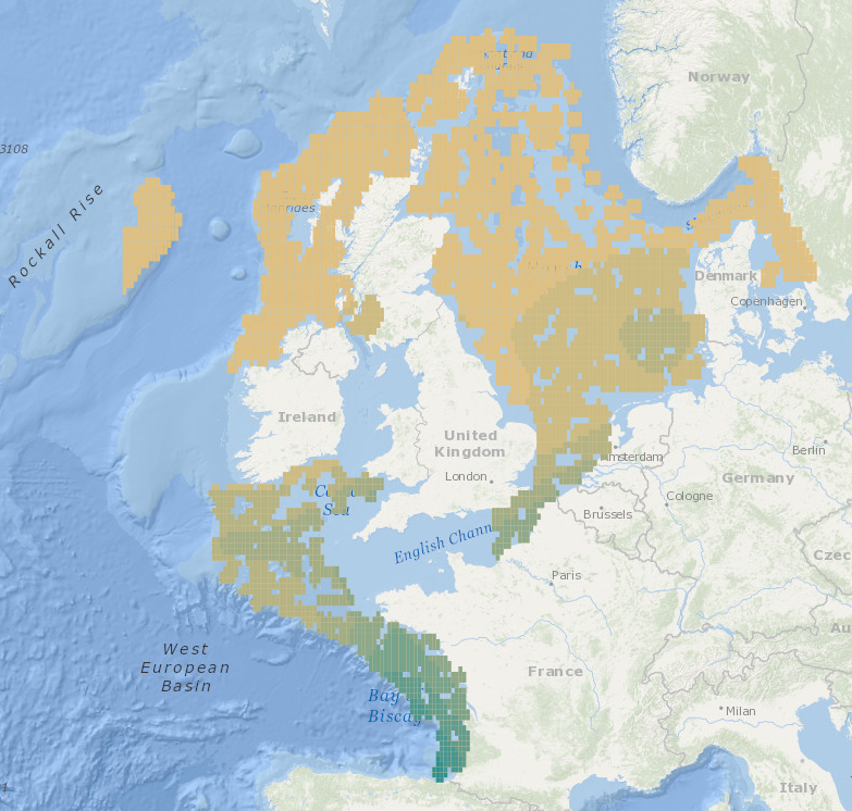
Intermediate Assessment 2017 - Seabed Litter - Litter is widespread on the seafloor across the area assessed, with plastic being the predominant material encountered. In the areas assessed, higher amounts of litter are found in the Eastern Bay of Biscay, Southern Celtic Seas and English Channel relative to the north of the Greater North Sea and Celtic Seas.
-

The Task Force on Hemispheric Transport of Air Pollution (TF HTAP) is an international scientific cooperative effort to improve the understanding of the intercontinental transport of air pollution across the Northern Hemisphere. TF HTAP was organized in 2005 under the auspices of the UNECE Convention on Long-range Transboundary Air Pollution (LRTAP Convention) and reports to the Convention’s EMEP Steering Body. However, participation is open to all interested experts, both inside and outside the UNECE region. TF HTAP organizes scientific cooperation in the areas of emissions inventories and projections, analysis of ambient monitoring and remote sensing, global and regional modeling, and impact assessment to understand the intercontinental flows of ozone and its precursors, fine particles and their components, mercury, and persistent organic pollutants (POPs). The main questions of interest to the TF HTAP relate to the benefits of international cooperation to decrease air pollution emissions: - How do air pollution concentrations (or deposition) in one region of the world change as emissions change in other regions or the world? - How do changes in emissions outside a region affect the health, ecosystem, and climate impacts of air pollution within a given region? - How does the feasibility of further emissions control differ in different regions of the world?
-
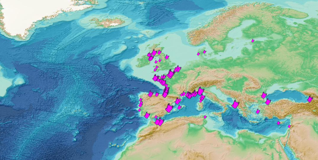
This visualization product displays the plastic bags abundance of marine macro-litter (> 2.5cm) per beach per year from non-MSFD monitoring surveys, research & cleaning operations. EMODnet Chemistry included the collection of marine litter in its 3rd phase. Since the beginning of 2018, data of beach litter have been gathered and processed in the EMODnet Chemistry Marine Litter Database (MLDB). The harmonization of all the data has been the most challenging task considering the heterogeneity of the data sources, sampling protocols and reference lists used on a European scale. Preliminary processing were necessary to harmonize all the data: - Exclusion of OSPAR 1000 protocol: in order to follow the approach of OSPAR that it is not including these data anymore in the monitoring; - Selection of surveys from non-MSFD monitoring, cleaning and research operations; - Exclusion of beaches without coordinates; - Selection of plastic bags related items only. The list of selected items is attached to this metadata. This list was created using EU Marine Beach Litter Baselines and EU Threshold Value for Macro Litter on Coastlines from JRC (these two documents are attached to this metadata); - Exclusion of surveys without associated length; - Normalization of survey lengths to 100m & 1 survey / year: in some case, the survey length was not 100m, so in order to be able to compare the abundance of litter from different beaches a normalization is applied using this formula: Number of plastic bags related items of the survey (normalized by 100 m) = Number of plastic bags related items of the survey x (100 / survey length) Then, this normalized number of plastic bags related items is summed to obtain the total normalized number of plastic bags related items for each survey. Finally, the median abundance of plastic bags related items for each beach and year is calculated from these normalized abundances of plastic bags related items per survey. Percentiles 50, 75, 95 & 99 have been calculated taking into account plastic bags related items from other sources data for all years. More information is available in the attached documents. Warning: the absence of data on the map doesn't necessarily mean that they don't exist, but that no information has been entered in the Marine Litter Database for this area.
-
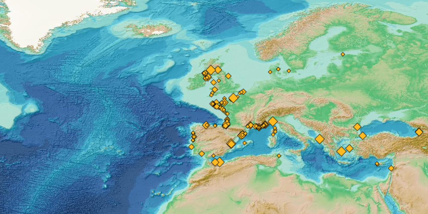
This visualization product displays the total abundance of marine macro-litter (> 2.5cm) per beach per year from non-MSFD monitoring surveys, research & cleaning operations. EMODnet Chemistry included the collection of marine litter in its 3rd phase. Since the beginning of 2018, data of beach litter have been gathered and processed in the EMODnet Chemistry Marine Litter Database (MLDB). The harmonization of all the data has been the most challenging task considering the heterogeneity of the data sources, sampling protocols and reference lists used on a European scale. Preliminary processing were necessary to harmonize all the data: - Exclusion of OSPAR 1000 protocol: in order to follow the approach of OSPAR that it is not including these data anymore in the monitoring; - Selection of surveys from non-MSFD monitoring, cleaning and research operations; - Exclusion of beaches without coordinates; - Some categories & some litter types like organic litter, small fragments (paraffin and wax; items > 2.5cm) and pollutants have been removed. The list of selected items is attached to this metadata. This list was created using EU Marine Beach Litter Baselines and EU Threshold Value for Macro Litter on Coastlines from JRC (these two documents are attached to this metadata). - Exclusion of surveys without associated length; - Normalization of survey lengths to 100m & 1 survey / year: in some case, the survey length was not 100m, so in order to be able to compare the abundance of litter from different beaches a normalization is applied using this formula: Number of items (normalized by 100 m) = Number of litter per items x (100 / survey length) Then, this normalized number of items is summed to obtain the total normalized number of litter for each survey. Finally, the median abundance for each beach and year is calculated from these normalized abundances per survey. Percentiles 50, 75, 95 & 99 have been calculated taking into account other sources data for all years. More information is available in the attached documents. Warning: the absence of data on the map doesn't necessarily mean that they don't exist, but that no information has been entered in the Marine Litter Database for this area.
-
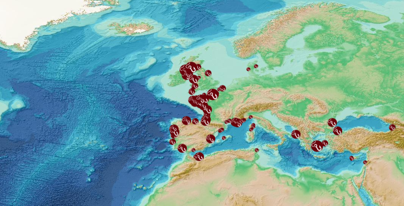
This visualization product displays the fishing & aquaculture related plastic items abundance of marine macro-litter (> 2.5cm) per beach per year from non-MSFD monitoring surveys, research & cleaning operations. EMODnet Chemistry included the collection of marine litter in its 3rd phase. Since the beginning of 2018, data of beach litter have been gathered and processed in the EMODnet Chemistry Marine Litter Database (MLDB). The harmonization of all the data has been the most challenging task considering the heterogeneity of the data sources, sampling protocols and reference lists used on a European scale. Preliminary processing were necessary to harmonize all the data: - Exclusion of OSPAR 1000 protocol: in order to follow the approach of OSPAR that it is not including these data anymore in the monitoring; - Selection of surveys from non-MSFD monitoring, cleaning and research operations; - Exclusion of beaches without coordinates; - Selection of fishing and aquaculture related plastic items only. The list of selected items is attached to this metadata. This list was created using EU Marine Beach Litter Baselines and EU Threshold Value for Macro Litter on Coastlines from JRC (these two documents are attached to this metadata); - Exclusion of surveys without associated length; - Normalization of survey lengths to 100m & 1 survey / year: in some case, the survey length was not 100m, so in order to be able to compare the abundance of litter from different beaches a normalization is applied using this formula: Number of fishing & aquaculture related plastic items of the survey (normalized by 100 m) = Number of fishing & aquaculture related items of the survey x (100 / survey length) Then, this normalized number of fishing & aquaculture related plastic items is summed to obtain the total normalized number of fishing & aquaculture related plastic items for each survey. Finally, the median abundance of fishing & aquaculture related plastic items for each beach and year is calculated from these normalized abundances of fishing & aquaculture related items per survey. Percentiles 50, 75, 95 & 99 have been calculated taking into account fishing & aquaculture related plastic items from other sources data for all years. More information is available in the attached documents. Warning: the absence of data on the map doesn't necessarily mean that they don't exist, but that no information has been entered in the Marine Litter Database for this area.
-
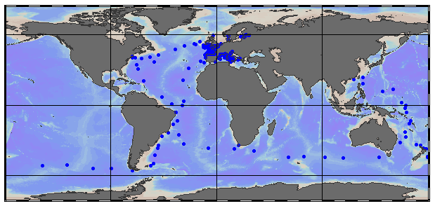
EMODnet Chemistry aims to provide access to marine chemistry data sets and derived data products concerning eutrophication, ocean acidification, contaminants and litter. The chosen parameters are relevant for the Marine Strategy Framework Directive (MSFD), in particular for descriptors 5, 8, 9 and 10. These datasets contain standardized, harmonized and validated data collections of floating micro-litter. For floating micro-litter, the harmonized datasets contain all unrestricted EMODnet Chemistry data on floating micro-litter data, including 907 CDI records. The temporal range covered is from 2011-06-14 to 2020-12-02. Data was harmonized by ‘Istituto Nazionale di Oceanografia e di Geofisica Sperimentale, Division of Oceanography (OGS/NODC)’ from Italy. Data is formatted following Guidelines and formats for gathering and management of micro-litter data sets on a European scale (floating and sediment micro-litter), which can be found at: https://doi.org/10.6092/d3e239ec-f790-4ee4-9bb4-c32ef39b426d. Parameter names in these datasets are based on P01, BODC Parameter Usage Vocabulary, which is available at: https://vocab.seadatanet.org/p01-facet-search. Each measurement value has a quality flag indicator. The resulting data collections are harmonized, using ODV Software and following a common methodology for all Sea Regions. Harmonization means that: (1) unit conversion is carried out to express variables with a limited set of measurement units and (2) merging of variables described by different “local names”, but corresponding exactly to the same concepts in BODC P01 vocabulary. The harmonized dataset can be downloaded as ODV collection and spreadsheet (TXT file), which is composed of a metadata header followed by tab separated values. Both formats can be opened with ODV Software for visualization (More information can be found at: https://www.seadatanet.org/Software/ODV ). The original datasets can be searched and downloaded from EMODnet Chemistry Chemistry CDI Data and Discovery Access Service: https://emodnet-chemistry.maris.nl/search
-

Impulsive or transient sounds of short duration and of high intensity constitute one of the criteria for defining good ecological status for descriptor 11 relating to the pressure of noise generated by human activities within the framework of the MSFD (D11C1). Good ecological status for sound energy is achieved when the risks of acoustic disturbance, excess mortality from sound exposure and reduction in communication distances of mysticetes are cumulatively low or moderate. For this, the spatial distribution, the temporal extent and the acoustic levels of the sources of anthropogenic impulsive sound must not exceed the levels harmful to the populations of marine animals. These criteria are evaluated at the scale of the marine sub-region for the “English Channel and North Sea”, “Celtic Seas” and “Western Mediterranean” regions; and at the scale of the "North" and "South" subdivisions in the "Bay of Biscay" sub-region. One of the indicators selected for the evaluation of criterion D11C1 is the spatial distribution of impulse emissions (D11C1.2). The pressures considered for the evaluation of the criterion are: acoustic emissions from air guns; acoustic emissions from impulsive sources other than air guns; emissions from non-impulsive (transient) sources; underwater explosions; emissions due to pile driving. The data used for the calculation of this indicator are declarative emissions data traced by the operators of the activities generating impulsive noise.
-

Impulsive or transient sounds of short duration and of high intensity constitute one of the criteria for defining good ecological status for descriptor 11 relating to the pressure of noise generated by human activities within the framework of the MSFD (D11C1). Good ecological status for sound energy is achieved when the risks of acoustic disturbance, excess mortality from sound exposure and reduction in communication distances of mysticetes are cumulatively low or moderate. For this, the spatial distribution, the temporal extent and the acoustic levels of the sources of anthropogenic impulsive sound must not exceed the levels harmful to the populations of marine animals. These criteria are evaluated at the scale of the marine sub-region for the “English Channel and North Sea”, “Celtic Seas” and “Western Mediterranean” regions; and at the scale of the "North" and "South" subdivisions in the "Bay of Biscay" sub-region. One of the indicators selected for the evaluation of criterion D11C1 is the distribution of the acoustic levels of impulsive emissions (D11C1.3). The pressures considered for the evaluation of the criterion are: acoustic emissions from air guns ; acoustic emissions from impulsive sources other than air guns ; emissions from non-impulsive (transient) sources ; underwater explosions ; emissions due to pile driving. The data used for the calculation of this indicator are declarative emissions data traced by the operators of the activities generating impulsive noise.
-
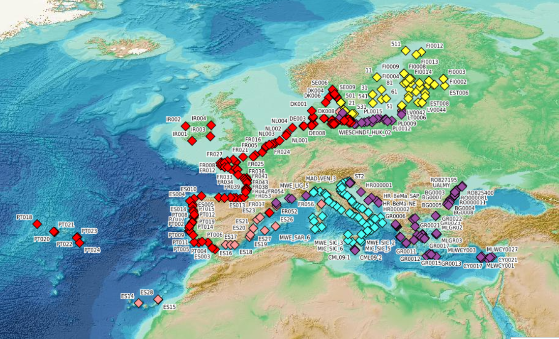
This visualization product displays beaches locations where the Marine Strategy Framework Directive (MSFD) monitoring protocol has been applied to collate data on macrolitter (> 2.5 cm). Reference lists associated with these protocols have been indicated with different colors in the map. EMODnet Chemistry included the collection of marine litter in its 3rd phase. Since the beginning of 2018, data of beach litter have been gathered and processed in the EMODnet Chemistry Marine Litter Database (MLDB). The harmonization of all the data has been the most challenging task considering the heterogeneity of the data sources, sampling protocols and reference lists used on a European scale. Preliminary processing were necessary to harmonize all the data: - Exclusion of OSPAR 1000 protocol: in order to follow the approach of OSPAR that it is not including these data anymore in the monitoring; - Selection of MSFD surveys only (exclusion of other monitoring, cleaning and research operations); - Exclusion of beaches without coordinates; - Some categories & some litter types like organic litter, small fragments (paraffin and wax; items > 2.5cm) and pollutants have been removed. The list of selected items is attached to this metadata. This list was created using EU Marine Beach Litter Baselines and EU Threshold Value for Macro Litter on Coastlines from JRC (these two documents are attached to this metadata). More information is available in the attached documents. Warning: the absence of data on the map doesn't necessarily mean that they don't exist, but that no information has been entered in the Marine Litter Database for this area.
-
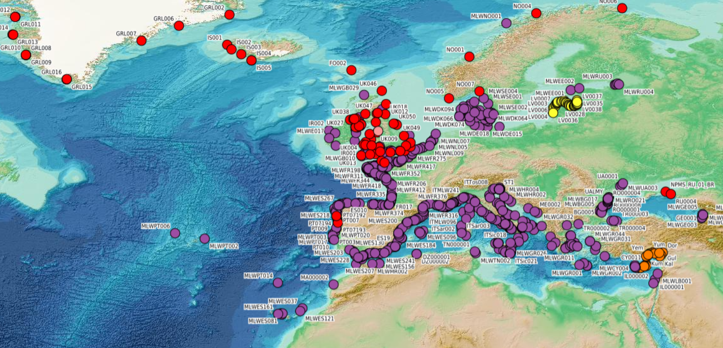
This visualization product displays beaches locations where non-MSFD monitoring surveys, research & cleaning operations have been applied to collate data on macrolitter (> 2.5 cm). Reference lists associated with these protocols have been indicated with different colors in the map. EMODnet Chemistry included the collection of marine litter in its 3rd phase. Since the beginning of 2018, data of beach litter have been gathered and processed in the EMODnet Chemistry Marine Litter Database (MLDB). The harmonization of all the data has been the most challenging task considering the heterogeneity of the data sources, sampling protocols and reference lists used on a European scale. Preliminary processing were necessary to harmonize all the data: - Exclusion of OSPAR 1000 protocol: in order to follow the approach of OSPAR that it is not including these data anymore in the monitoring; - Selection of surveys from non-MSFD monitoring, cleaning and research operations; - Exclusion of beaches without coordinates; - Some categories & some litter types like organic litter, small fragments (paraffin and wax; items > 2.5cm) and pollutants have been removed. The list of selected items is attached to this metadata. This list was created using EU Marine Beach Litter Baselines and EU Threshold Value for Macro Litter on Coastlines from JRC (these two documents are attached to this metadata). More information is available in the attached documents. Warning: the absence of data on the map doesn't necessarily mean that they don't exist, but that no information has been entered in the Marine Litter Database for this area.