 Catalogue PIGMA
2004
Type of resources
Available actions
Topics
Keywords
Contact for the resource
Provided by
Years
Formats
Representation types
Update frequencies
status
Scale
Resolution
-

These products contain global non time critical (NTC) reprocessed (REP) Level 2P skin Sea Surface Temperature (SST) derived from SLSTR-A on Copernicus Sentinel-3 at full-resolution swath (1 km at nadir) in GHRSST compliant NetCDF format. All SSTs from the Sea and Land Surface Temperature Radiometer (SLSTR) series of instruments are SST skin measurements. For more details please see “What is SST?” on the GHRSST web pages. At night, the skin temperature is typically a few tenths of a degree cooler than the temperature measured by in situ systems; in the day, the skin can be considerably higher if strong diurnal warming is present. The SLSTRs are dual-view self-calibrating radiometers with SST retrieved from spectral bands at nominally 3.74, 10.85 and 12 µm (referred to as S7, S8 & S9). Corrections for water vapour atmospheric absorption are performed using a triple window at night, and a split window during the day as the 3.7 µm channel is not used due to solar contamination. All pixels in the dual-view part of the swath are viewed twice, via nadir and oblique views with different atmospheric path lengths, allowing for correction for aerosol effects. Consequently, there are four possible retrieved SSTs, referred to as N2 (nadir-only 11 µm and 12 µm), N3 (nadir-only 3.7 µm, 11 µm and 12 µm), D2 (dual-view 11 µm and 12 µm) and D3 (dual-view 3.7 µm, 11 µm and 12 µm). The L2P file contains the best SST available for each pixel and flags are included to identify which retrieval is used. If the observation is in the nadir-only / single-view part of swath then "sst_algorithm_types" is N2 or N3, and if the observation is in the dual-view part of swath then "sst_algorithm_types" is D2 or D3. For D2 or D3 pixels it is possible to generate their N2 or N3 equivalent by subtracting the value in the "dual_nadir_sst_difference" field. Users are advised to use only QL = 5 dual-view SSTs for reference sensor applications and to use single-view (all quality levels) and quality level 3 and 4 dual-view data only for other qualitative analysis. Users are reminded to apply the SSES bias adjustments as SLSTR-B is harmonised to SLSTR-A through SSES. Users can consider using the "theoretical_uncertainty" for weighting observations rather than the simple SSES standard deviation values. Primary access to data is via the EUMETSAT Data Store (linked below). Other access methods can be found in the EUMETSAT Product Navigator https://navigator.eumetsat.int/product/EO:EUM:DAT:0582?query=slstr&results=22&s=advanced. Please also read the EUMETSAT SLSTR Product Notices (linked below) as they provide a lot of useful information. All products currently contain SLSTRA-MAR-L2P-v1.0 as the GHRSST Collection ID in the file metadata, which will be revised in a future release.
-
These products contain global near real time (NRT) Level 2P skin Sea Surface Temperature (SST) derived from SLSTR-A on Copernicus Sentinel-3 at full-resolution swath (1 km at nadir) in GHRSST compliant NetCDF format. All SSTs from the Sea and Land Surface Temperature Radiometer (SLSTR) series of instruments are SST skin measurements. For more details please see “What is SST?” on the GHRSST web pages. At night, the skin temperature is typically a few tenths of a degree cooler than the temperature measured by in situ systems; in the day, the skin can be considerably higher if strong diurnal warming is present. The SLSTRs are dual-view self-calibrating radiometers with SST retrieved from spectral bands at nominally 3.74, 10.85 and 12 µm (referred to as S7, S8 & S9). Corrections for water vapour atmospheric absorption are performed using a triple window at night, and a split window during the day as the 3.7 µm channel is not used due to solar contamination. All pixels in the dual-view part of the swath are viewed twice, via nadir and oblique views with different atmospheric path lengths, allowing for correction for aerosol effects. Consequently, there are four possible retrieved SSTs, referred to as N2 (nadir-only 11 µm and 12 µm), N3 (nadir-only 3.7 µm, 11 µm and 12 µm), D2 (dual-view 11 µm and 12 µm) and D3 (dual-view 3.7 µm, 11 µm and 12 µm). The L2P file contains the best SST available for each pixel and flags are included to identify which retrieval is used. If the observation is in the nadir-only / single-view part of swath then "sst_algorithm_types" is N2 or N3, and if the observation is in the dual-view part of swath then "sst_algorithm_types" is D2 or D3. For D2 or D3 pixels it is possible to generate their N2 or N3 equivalent by subtracting the value in the "dual_nadir_sst_difference" field. Users are advised to use only QL = 5 dual-view SSTs for reference sensor applications and to use single-view (all quality levels) and quality level 3 and 4 dual-view data only for other qualitative analysis. Users are reminded to apply the SSES bias adjustments as SLSTR-B is harmonised to SLSTR-A through SSES. Users can consider using the "theoretical_uncertainty" for weighting observations rather than the simple SSES standard deviation values. Primary access to data is via the EUMETSAT Data Store (linked below). Other access methods can be found in the EUMETSAT Product Navigator https://navigator.eumetsat.int/product/EO:EUM:DAT:SENTINEL-3:SL_2_WST___NRT?query=slstr&results=22&s=advanced. Please also read the EUMETSAT SLSTR Product Notices (linked below) as they provide a lot of useful information. All products currently contain SLSTRA-MAR-L2P-v1.0 as the GHRSST Collection ID in the file metadata, which will be revised in a future release.
-
Auteur(s): Mähler Quiterie , Ce travail porte sur les rapports de l'architecture et du théâtre. S'attachant, plus précisément au théâtre de rue, l'auteur en analyse les spécificités spatiales en insistant sur la relations espace scénique-espace public et la délimitation scène-public et intérieur-extérieur. Son interrogation sur la notion de lieu itinérant aboutit à une proposition architecturale dédiée au théâtre nomade, combinant structure fixe et structure mobile.
-

The primary aim of the Fisheries and Resources Monitoring System (FIRMS) is to provide access to a wide range of high-quality information on the global monitoring and management of fishery marine resources. FIRMS draws together a unified partnership of international organizations, regional fishery bodies and, in the future, national scientific institutes, collaborating within formal agreement to report and share information on fisheries resources. For effective fisheries information management, FIRMS also participates in the development and promotion of agreed standards. FIRMS system is part of the Fisheries Global Information System (FIGIS). Information provided by the partners is organized in a database and published in the form of fact sheets. This system provides the data owner with tools to ensure controlled dissemination of high quality and updated information.
-

These products contain global non time critical (NTC) Level 2P skin Sea Surface Temperature (SST) derived from SLSTR-B on Copernicus Sentinel-3 at full-resolution swath (1 km at nadir) in GHRSST compliant NetCDF format. All SSTs from the Sea and Land Surface Temperature Radiometer (SLSTR) series of instruments are SST skin measurements. For more details please see “What is SST?” on the GHRSST web pages. At night, the skin temperature is typically a few tenths of a degree cooler than the temperature measured by in situ systems; in the day, the skin can be considerably higher if strong diurnal warming is present. The SLSTRs are dual-view self-calibrating radiometers with SST retrieved from spectral bands at nominally 3.74, 10.85 and 12 µm (referred to as S7, S8 & S9). Corrections for water vapour atmospheric absorption are performed using a triple window at night, and a split window during the day as the 3.7 µm channel is not used due to solar contamination. All pixels in the dual-view part of the swath are viewed twice, via nadir and oblique views with different atmospheric path lengths, allowing for correction for aerosol effects. Consequently, there are four possible retrieved SSTs, referred to as N2 (nadir-only 11 µm and 12 µm), N3 (nadir-only 3.7 µm, 11 µm and 12 µm), D2 (dual-view 11 µm and 12 µm) and D3 (dual-view 3.7 µm, 11 µm and 12 µm). The L2P file contains the best SST available for each pixel and flags are included to identify which retrieval is used. If the observation is in the nadir-only / single-view part of swath then "sst_algorithm_types" is N2 or N3, and if the observation is in the dual-view part of swath then "sst_algorithm_types" is D2 or D3. For D2 or D3 pixels it is possible to generate their N2 or N3 equivalent by subtracting the value in the "dual_nadir_sst_difference" field. Users are advised to use only QL = 5 dual-view SSTs for reference sensor applications and to use single-view (all quality levels) and quality level 3 and 4 dual-view data only for other qualitative analysis. Users are reminded to apply the SSES bias adjustments as SLSTR-B is harmonised to SLSTR-A through SSES. Users can consider using the "theoretical_uncertainty" for weighting observations rather than the simple SSES standard deviation values. Primary access to data is via the EUMETSAT Data Store (linked below). Other access methods can be found in the EUMETSAT Product Navigator https://navigator.eumetsat.int/product/EO:EUM:DAT:SENTINEL-3:SL_2_WST___NTC?query=slstr&results=22&s=advanced. Please also read the EUMETSAT SLSTR Product Notices (linked below) as they provide a lot of useful information. All products currently contain SLSTRB-MAR-L2P-v1.0 as the GHRSST Collection ID in the file metadata, which will be revised in a future release.
-

These products contain global non time critical (NTC) Level 2P skin Sea Surface Temperature (SST) derived from SLSTR-A on Copernicus Sentinel-3 at full-resolution swath (1 km at nadir) in GHRSST compliant NetCDF format. All SSTs from the Sea and Land Surface Temperature Radiometer (SLSTR) series of instruments are SST skin measurements. For more details please see “What is SST?” on the GHRSST web pages. At night, the skin temperature is typically a few tenths of a degree cooler than the temperature measured by in situ systems; in the day, the skin can be considerably higher if strong diurnal warming is present. The SLSTRs are dual-view self-calibrating radiometers with SST retrieved from spectral bands at nominally 3.74, 10.85 and 12 µm (referred to as S7, S8 & S9). Corrections for water vapour atmospheric absorption are performed using a triple window at night, and a split window during the day as the 3.7 µm channel is not used due to solar contamination. All pixels in the dual-view part of the swath are viewed twice, via nadir and oblique views with different atmospheric path lengths, allowing for correction for aerosol effects. Consequently, there are four possible retrieved SSTs, referred to as N2 (nadir-only 11 µm and 12 µm), N3 (nadir-only 3.7 µm, 11 µm and 12 µm), D2 (dual-view 11 µm and 12 µm) and D3 (dual-view 3.7 µm, 11 µm and 12 µm). The L2P file contains the best SST available for each pixel and flags are included to identify which retrieval is used. If the observation is in the nadir-only / single-view part of swath then "sst_algorithm_types" is N2 or N3, and if the observation is in the dual-view part of swath then "sst_algorithm_types" is D2 or D3. For D2 or D3 pixels it is possible to generate their N2 or N3 equivalent by subtracting the value in the "dual_nadir_sst_difference" field. Users are advised to use only QL = 5 dual-view SSTs for reference sensor applications and to use single-view (all quality levels) and quality level 3 and 4 dual-view data only for other qualitative analysis. Users are reminded to apply the SSES bias adjustments as SLSTR-B is harmonised to SLSTR-A through SSES. Users can consider using the "theoretical_uncertainty" for weighting observations rather than the simple SSES standard deviation values. Primary access to data is via the EUMETSAT Data Store (linked below). Other access methods can be found in the EUMETSAT Product Navigator https://navigator.eumetsat.int/product/EO:EUM:DAT:SENTINEL-3:SL_2_WST___NTC?query=slstr&results=22&s=advanced. Please also read the EUMETSAT SLSTR Product Notices (linked below) as they provide a lot of useful information. All products currently contain SLSTRA-MAR-L2P-v1.0 as the GHRSST Collection ID in the file metadata, which will be revised in a future release.
-
These products contain global near real time (NRT) Level 2P skin Sea Surface Temperature (SST) derived from SLSTR-B on Copernicus Sentinel-3 at full-resolution swath (1 km at nadir) in GHRSST compliant NetCDF format. All SSTs from the Sea and Land Surface Temperature Radiometer (SLSTR) series of instruments are SST skin measurements. For more details please see “What is SST?” on the GHRSST web pages. At night, the skin temperature is typically a few tenths of a degree cooler than the temperature measured by in situ systems; in the day, the skin can be considerably higher if strong diurnal warming is present. The SLSTRs are dual-view self-calibrating radiometers with SST retrieved from spectral bands at nominally 3.74, 10.85 and 12 µm (referred to as S7, S8 & S9). Corrections for water vapour atmospheric absorption are performed using a triple window at night, and a split window during the day as the 3.7 µm channel is not used due to solar contamination. All pixels in the dual-view part of the swath are viewed twice, via nadir and oblique views with different atmospheric path lengths, allowing for correction for aerosol effects. Consequently, there are four possible retrieved SSTs, referred to as N2 (nadir-only 11 µm and 12 µm), N3 (nadir-only 3.7 µm, 11 µm and 12 µm), D2 (dual-view 11 µm and 12 µm) and D3 (dual-view 3.7 µm, 11 µm and 12 µm). The L2P file contains the best SST available for each pixel and flags are included to identify which retrieval is used. If the observation is in the nadir-only / single-view part of swath then "sst_algorithm_types" is N2 or N3, and if the observation is in the dual-view part of swath then "sst_algorithm_types" is D2 or D3. For D2 or D3 pixels it is possible to generate their N2 or N3 equivalent by subtracting the value in the "dual_nadir_sst_difference" field. Users are advised to use only QL = 5 dual-view SSTs for reference sensor applications and to use single-view (all quality levels) and quality level 3 and 4 dual-view data only for other qualitative analysis. Users are reminded to apply the SSES bias adjustments as SLSTR-B is harmonised to SLSTR-A through SSES. Users can consider using the "theoretical_uncertainty" for weighting observations rather than the simple SSES standard deviation values. Primary access to data is via the EUMETSAT Data Store (linked below). Other access methods can be found in the EUMETSAT Product Navigator https://navigator.eumetsat.int/product/EO:EUM:DAT:SENTINEL-3:SL_2_WST___NRT?query=slstr&results=22&s=advanced. Please also read the EUMETSAT SLSTR Product Notices (linked below) as they provide a lot of useful information. All products currently contain SLSTRB-MAR-L2P-v1.0 as the GHRSST Collection ID in the file metadata, which will be revised in a future release.
-
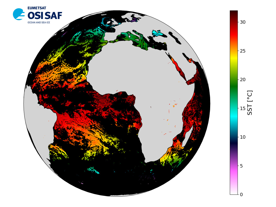
Level 3 hourly sub-skin Sea Surface Temperature derived from Meteosat at 0° longitude, covering 60S-60N and 60W-60E and re-projected on a 0.05° regular grid, in GHRSST compliant netCDF format. The satellite input data has successively come from Meteosat level 1 data processed at EUMETSAT. SST is retrieved from SEVIRI using a multi-spectral algorithm and a cloud mask. Atmospheric profiles of water vapor and temperature from a numerical weather prediction model, Sea Surface Temperature from an analysis, together with a radiative transfer model, are used to correct the multispectral algorithm for regional and seasonal biases due to changing atmospheric conditions.The quality of the products is monitored regularly by daily comparison of the satellite estimates against buoy measurements. The product format is compliant with the GHRSST Data Specification (GDS) version 2. Users are advised to use data only with quality levels 3, 4 and 5.
-
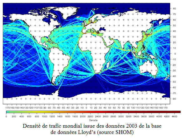
Cette base de données contient les mouvements des navires affiliés à la Lloyd’s. Elle permet d’avoir une cartographie de la densité de trafic maritime en particulier pour la composante « transports de marchandises ». Ces densités sont exploitées pour la caractérisation des tendances et pour la modélisation du bruit de trafic dans chaque SRM. Ce dispositif a été utilisé pour l’évaluation initiale du D11a (base de données de trafic de l’année 2003)
-
Levés de terrain pour la détermination des phénomènes structuraux marins.