 Catalogue PIGMA
/Ocean Waves
Type of resources
Topics
Keywords
Contact for the resource
Provided by
Years
Formats
Representation types
status
Resolution
-

The Sentinel-6 Level-2P skewness products was developed to estimate the skewness from Sentinel-6 LR (Low Resolution Mode) and HR (High Resolution Mode) acquisitions. That demonstration product is generated by different retracking processes, provides an initial estimation of such a phenomenon and allows a finer description of the sea state.
-

Operational altimetry processing traditionally relies on a “frozen sea” assumption, neglecting the influence of ocean dynamics on Doppler frequencies and introducing biases in estimated sea-state parameters. This dataset is based on an advanced SAR (Delay-Doppler) processing approach that overcomes this limitation by explicitly accounting for ocean surface dynamics. The methodology incorporates enhanced SAR models that jointly retrieve the standard deviation of vertical wave orbital velocities and the along-track component of the geophysical Doppler vector. These quantities are estimated through full two-dimensional retracking of unfocused SAR Delay-Doppler maps (stacks), rather than through the conventional summed Doppler beam approach used in operational processing. The processing has been implemented within the Sentinel Processing Prototype (SPP), leading to the generation of two six-month Sentinel-6A (S6A) data series covering January–June 2022 and January–June 2024. Validation results show that the dataset is fully consistent with conventional altimetry products in terms of sea surface height (SSH) and significant wave height (SWH), while providing reduced noise levels and improved along-track resolution. Key added-value parameters and improvements include: • Vertical wave velocity statistics: The dataset characterizes azimuth smearing induced by vertical wave motion, enabling the retrieval of the standard deviation of vertical wave velocity. This parameter is directly related to the mean zero up-crossing wave period and refines the estimation of sea-state conditions. Its inclusion reduces sea-state-dependent biases in SWH and shows strong agreement with ERA5 wave model outputs without requiring external corrections. • Geophysical Doppler contribution: The along-track component of the geophysical Doppler vector is estimated, providing information linked to wind direction and intensity, as well as surface currents (including contributions such as Stokes drift). Accounting for this term significantly reduces wind-dependent SSH biases, particularly between ascending and descending passes, while preserving large-scale spectral content. This dataset constitutes a demonstration product designed for the scientific community, showcasing the potential of advanced SAR retracking techniques. It delivers enhanced-resolution altimetry measurements together with improved SSH and SWH estimates, wave-period-related diagnostics derived from vertical velocity, and geophysical Doppler information. These features open new perspectives for coastal ocean applications, surface current studies, and swell characterization.
-

The main objective of the SWIM Level 2S (L2S) product is to provide along-track directional wave spectra measures, as well as the integrated parameters of the associated wave systems (wave length, significant wave height, direction), over the global ocean, as observed with SWIM instrument onboard CFOSAT. CFOSAT (Chinese French Ocean SATellite) is a french-chinese mission launched in 2018, whose aim is to provide wind (SCAT instrument) and wave (SWIM instrument) measurements over the sea surface. The wave spectra and their associated partitions are provided independently for each SWIM incidence (from 2° to 10°), together with the sigma0 resampled at a 20m resolution. They are complemented with information from the nadir beam such as the sigma0, wind speed, significant wave height or rain flag. The SWIM level 2S (L2S) product is generated in delayed mode, a few days after acquisition. It complements the Near-Real Time (NRT) L2 product delivered by the CWWIC center by providing an alternative and evolutive processing to test and implement quickly new algorithms for the wave inversion over the whole mission archive. These evolutions may take advantage of better ancillary data not available in NRT (ice mask product, best estimates of wind or wave model), of the combination with wind measurements from the onboard SCAT scatterometer. The product is also designed to handle complex situations such as coastal areas and heterogeneous seas. These complex situations are by nature of particular scientific interest (e.g. wind wave interactions, wave evolution in coastal region). This version 2 improves the previous release in particular through a new empirical modulation transfer function (MTF) and better partitioning. The dataset is also lighter in size. It has been completely reprocessed from SWIM Level 1 archive. Note that the dataset is split on the access server in two different sub-versions (**2.0** for the L2S using Level 1 in OP06 version, **2.1** for the L2S using Level 1 in OP07 version). No major differences are expected. The SWIM L2S product is generated and distributed by Ifremer / CERSAT in the frame of the Ifremer Wind and Wave Operation Center (IWWOC) co-funded by Ifremer and CNES and dedicated to the processing of the delayed mode data of CFOSAT mission.
-
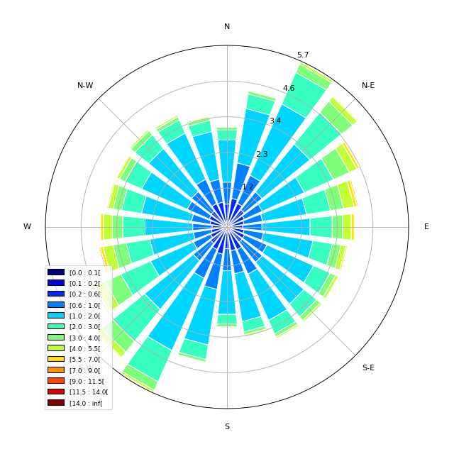
The main objective of the SWIM Level 3 (L3) product is to provide global gridded wave statistics from the along-track directional wave spectra measures, as observed with SWIM instrument onboard CFOSAT. CFOSAT (Chinese French Ocean SATellite) is a french-chinese mission launched in 2018, whose aim is to provide wind (SCAT instrument) and wave (SWIM instrument) measurements over the sea surface. The processing uses the integrated parameters (wave length, significant wave height, direction) of the wave systems associated with the individual partitions retrieved from SWIM wave spectra, computing monthly statistics such as distribution, min, max, mean and median over a global 2 degree resolution grid. Three sub-products are generated separately for each SWIM beam (from 4° to 10°) from respectively the SWIM Level 2 spectra produced by the CWWIC center (CNES), the SWIM Level 2S spectra produced by the IWWOC center (Ifremer) and forecast spectra produced from WaveWatch3 wave model at Ifremer as an independent source for comparison. The SWIM level 3 dataset is generated in delayed mode. It is currently mainly meant as a validation dataset aiming at inter-comparing the different SWIM Level 2 between each other, with an independent model (here WaveWatch3) or other external similar wave statistics products. The SWIM L3 dataset is generated and distributed by Ifremer / CERSAT in the frame of the Ifremer Wind and Wave Operation Center (IWWOC) co-funded by Ifremer and CNES and dedicated to the processing of the delayed mode data of CFOSAT mission.
-

-
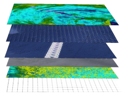
The SWISCA Level 2S (L2S) product provides along-track colocation of SWIM wave measuring instrument onto SCAT scatterometer grid, over the global ocean. SWIM and SCAT are both instruments onboard CFOSAT. CFOSAT (Chinese French Ocean SATellite) is a french-chinese mission launched in 2018, whose aim is to provide wind (SCAT instrument) and wave (SWIM instrument) measurements over the sea surface. The SWISCA L2S product is broken down into three different subproducts: - L2A containing the sigma0 of both SWIM and SCAT - L2B containing the wave parameters measured by SWIM and wind vectors measured by SCAT - AUX containing additional ancillary fields such as sea ice concentration (from CERSAT/SSMI), ocean currents (from CMEMS/GlobCurrent), SST and Wind (from ECMWF), rain rate (from IMERG), and WaveWatch3 wave spectra. All SWIM and ancillary observations are resampled onto SCAT scatterometer's geometry (wind vector cells, WVC). The SWISCA level 2S product is generated in delayed mode, a few days after acquisition. It is intended to foster cross analysis of SWIM and SCAT observations, and their combination to improve the retrieval of both wind and wave parameters. The SWISCA L2S product is generated and distributed by Ifremer / CERSAT in the frame of the Ifremer Wind and Wave Operation Center (IWWOC) co-funded by Ifremer and CNES and dedicated to the processing of the delayed mode data of CFOSAT mission.