 Catalogue PIGMA
Waves
Type of resources
Available actions
Topics
Keywords
Contact for the resource
Provided by
Years
Formats
Representation types
Update frequencies
status
Scale
Resolution
-
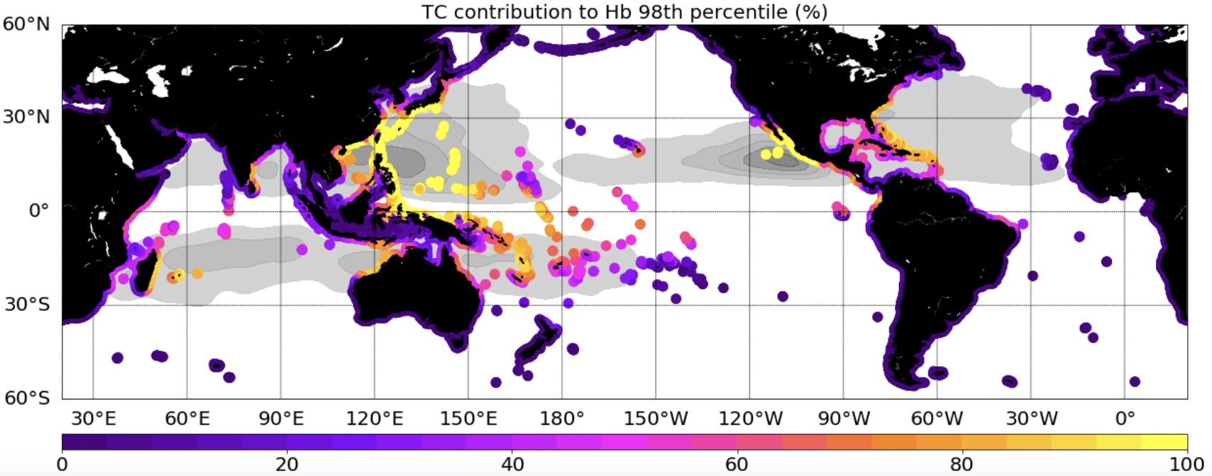
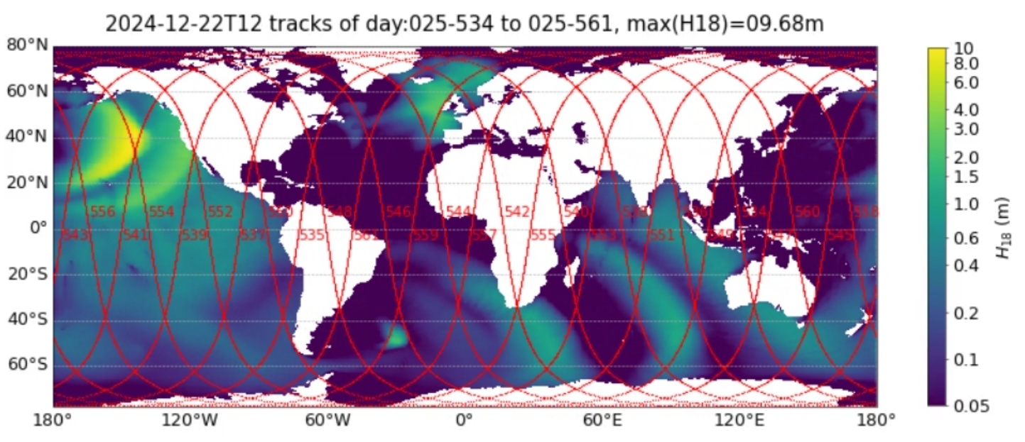
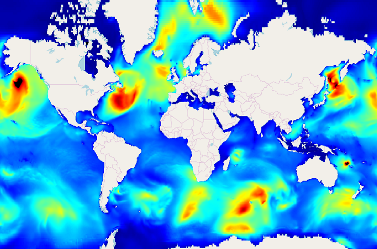
This dataset provides extreme waves (Hs: significant wave height, Hb:breaking wave height, a proxy of the wave energy flux) simulated with the WWIII model, and extracted along global coastlines. Two simulations, including or not Tropical Cyclones (TCs) in the forcing wind field, are provided.
-
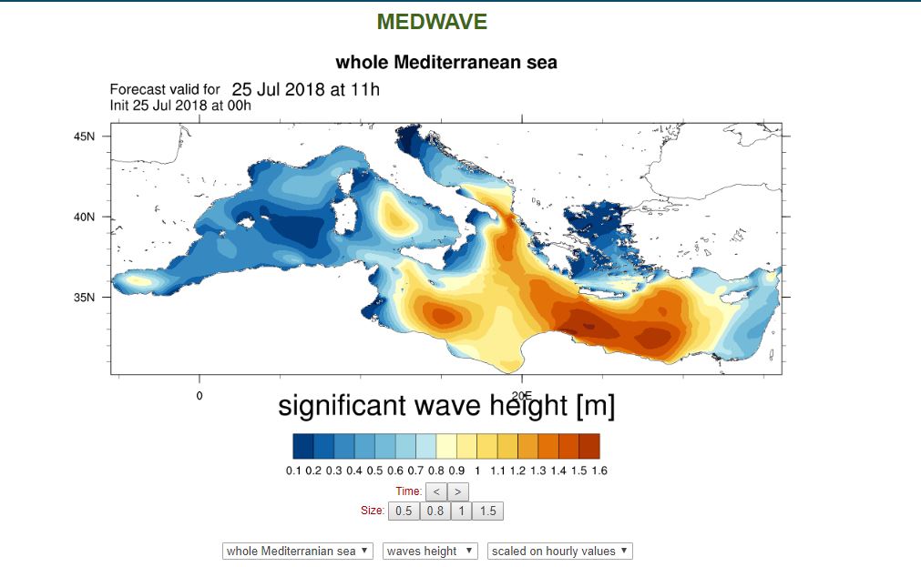
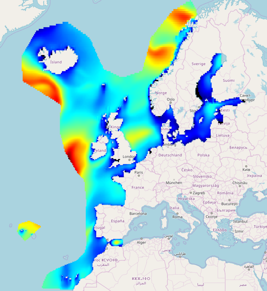
Web portal providing wave energy forecast at the spatial resolution of 1/32°. Higher resolution forecasts (1/128°) are computed over ten sub-basins around the Italian coasts.
-
During the SARDINIA experiment, three coincident MCS reflection and wide-angle seismic profiles, sub-bottom high resolution (CHIRP) profiles, and bathymetry data were collected on the Gulf of Lion margin. The seismic reflection data were acquired using a 4.5 km, 360 trace digital streamer and a tuned airgun array of 8260 in3, towed at a depth of 18-28 m. A total of 57 ocean bottom seismometer/ hydrophones (OBS/OBH) from Ifremer, University of Brest, and Geomar Kiel were deployed in the Gulf of Lion, spaced every 7 Nm (~13 km). The airgun array consists of 16 airguns ranging from 100 in3 G-guns to 16 L Bolt airguns, with main frequencies centered around 10-15 Hz. The airguns were tuned to the first bubble to enhance low frequencies and ensure a good penetration. The shot interval was 60 s at an average speed of 5 knots, which translates to a trace spacing of about 140-150 m. The sample rate was 8 ms for the micrOBS, 5 ms for the Geomar’s OBS and 4 ms for the OldOBS. A total of 6160 shots (profile AB: 3032, profile CD: 1730, profile EF: 1398) were fired by the air gun array. Profile AB crosses the Gulf of Lion’s margin, parallel to the ECORS profile, from the continental shelf to Domain III. Twenty-five ocean bottom seismometers (OBS) were deployed on this profile, of 467 km in length. Twenty-two instruments were used in the wide-angle modelling, since three instruments (OBS 45, 49 and 52) did not properly record. The shots on this profile were additionally recorded by 9 land seismic stations (OSIRIS stations from the University of Brest and Geosciences Azur) that have extended the marine profile ~120 km onshore. Profiles CD and EF are 250 and 210 km long transects parallel to the margin. Profile CD was acquired using 19 OBS of which 18 yielded usable data. Profile EF was acquired using 15 OBS of which 12 yielded usable data. These two profiles cross the profile AB, respectivelyat OBS 26 and OBS 8.
-
Global wave hindcast (1961-2020) at 1° resolution using CMIP6 wind and sea-ice forcings for ALL (historical), GHG (historical greenhouse-gas-only), AER (historical Anthropogenic-aerosol-only), NAT (historical natural only) scenario.
-
Wave hindcast based on WAVEWATCH III ® with parameterization from Romero (2019) adapted by Alday and Ardhuin (2023) as “TEST702”.
-
IOWAGA sea-states hindcast database generated by the wave model WAVEWATCH-III and forced by CFSR winds on the North East Atlantic grid over 1990-2012 period.
-
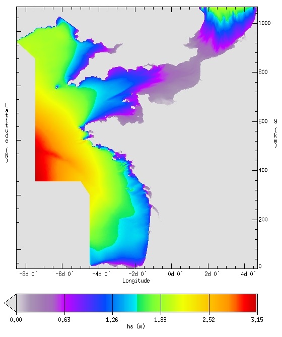
IOWAGA sea-states forecast best estimate generated by the wave model WAVEWATCH-III and forced by ECMWF winds on the French coast of the Atlantic ocean unstructured grid from 2017 to now
-
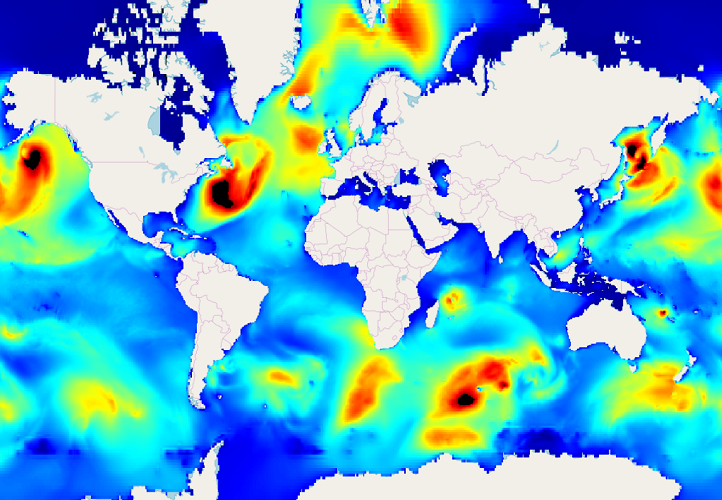
IOWAGA sea-states hindcast database generated by the wave model WAVEWATCH-III and forced by ECMWF winds on the Global grid over 1990-2012 period.
-
IOWAGA sea-states hindcast database generated by the wave model WAVEWATCH-III and forced by CFSR winds on the Global grid over 1990-2012 period.
-
This product integrates observations aggregated and validated from the Regional EuroGOOS consortium (Arctic-ROOS, BOOS, NOOS, IBI-ROOS, MONGOOS and Black Sea GOOS) as well as from National Data Centers (NODCs) and JCOMM global systems (Argo, GOSUD, OceanSITES, GTSPP, DBCP) and the Global telecommunication system (GTS) used by the Met Offices. Data are available in a dedicated directory to waves (INSITU_GLO_WAV_REP_OBSERVATIONS_013_045) of GLOBAL Distribution Unit in one file per platform. This directory is updated twice a year. Data are distributed in two datasets, one with original time sampling and the other with hourly data and rounded timestamps. The information distributed includes wave parameters and wave spectral information. The latest version of Copernicus delayed-mode wave product is distributed from Copernicus Marine catalogue. Additional credits: The American wave data are collected from US NDBC (National Data Buoy Center). The Australian wave data are collected from Integrated Marine Observing System (IMOS); IMOS is enabled by the National Collaborative Research Infrastructure Strategy (NCRIS); It is operated by a consortium of institutions as an unincorporated joint venture, with the University of Tasmania as Lead Agent. The Canadian data are collected from Fisheries and Oceans Canada.