 Catalogue PIGMA
Atmospheric pressure
Type of resources
Available actions
Topics
Keywords
Contact for the resource
Provided by
Years
Formats
Representation types
Update frequencies
status
Scale
-
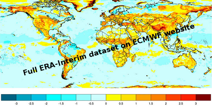
ERA-Interim is a dataset, showing the results of a global climate reanalysis from 1979 to date. ERA-Interim continues to be updated in near-real-time as new data becomes available.
-
The National Centers for Environmental Prediction (NCEP) Climate Forecast System (CFS) is initialized four times per day (0000, 0600, 1200, and 1800 UTC). NCEP upgraded their operational CFS to version 2 on March 30, 2011. This is the same model that was used to create the NCEP Climate Forecast System Reanalysis (CFSR), and the purpose of this dataset is to extend CFSR. The 6-hourly atmospheric, oceanic and land surface analyzed products and forecasts, available at 0.2, 0.5, 1.0, and 2.5 degree horizontal resolutions, are archived here beginning with January 1, 2011 as an extension of CFSR.
-
The CORE-II simulations provide a framework to evaluate ocean model performance, to study mechanisms of ocean phenomena and their variability from seasonal to decadal timescales, to identify forced variability changes, and to develop mechanistic descriptions of observed climate variability and change.
-
The DBCP – Data Buoy Cooperation Panel - is an international program coordinating the use of autonomous data buoys to observe atmospheric and oceanographic conditions, over ocean areas where few other measurements are taken. DBCP coordinates the global array of 1 600 active drifting buoys (August 2020) and historical observation from 14 000 drifting buoys. Data and metadata collected by drifting buoys are publically available in near real-time via the Global Data Assembly Centers (GDACs) in Coriolis-Ifremer (France) and MEDS (Canada) after an automated quality control (QC). In long term, scientifically quality controlled delayed mode data will be distributed on the GDACs. Disclaimer: the DB-GDAC is under construction. It is currently (January 2020) aggregating data from the Coriolis DAC (E-Surfmar, Canada). Additional DACs are considered. An interim provision from GTS real-time data to GDAC may be provided from Coriolis DAC.
-
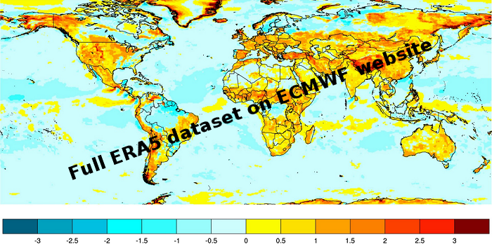
ERA5 is a climate reanalysis dataset, covering the period 1979 to present. ERA5 is being developed through the Copernicus Climate Change Service (C3S). Extracted data available here are one hourly at a regular grid lat,lon 0.25*0.25
-
The Drifting Buoys GDAC -Global Data Assembly Centre- is the repository of surface drifters data. Both NRT -Near Real Time- and DM -Delayed Mode- data are available on the GDAC. Drifters report generally trajectories, sea-surface temperatures, atmospheric pressures at sea-level, as well as sea-surface salinity or sub-surface temperature in the ocean top layer.
-

The Surface Ocean CO₂ Atlas (SOCAT) is a synthesis activity for quality-controlled, surface ocean fCO₂ (fugacity of carbon dioxide) observations by the international marine carbon research community (>100 contributors). SOCAT data is publicly available, discoverable and citable. SOCAT enables quantification of the ocean carbon sink and ocean acidification and evaluation of ocean biogeochemical models. SOCAT represents a milestone in biogeochemical and climate research and in informing policy. SOCAT data are released in versions. Each succeeding version contains new data sets as well as updates of older ones. The first version of SOCAT was released in 2011, the second and third version followed biennially. Automation allowed annual public releases since version 4. The latest SOCAT version (version 5) has 21.5 million observations from 1957 to 2017 for the global oceans and coastal seas. SOCAT contains data from the VOS, OceanSites network and mooring, buoy data in general as well as calibrated sensor data.
-
The Global Sea Level Observing System (GLOSS) was established by the Intergovernmental Oceanographic Commission (IOC) of UNESCO in 1985 to establish a well-designed, high-quality in situ sea level observing network to support a broad research and operational user base. Various tide gauge networks have contributed to GLOSS, each with a different focus and each changing over time as research priorities evolve. The main component is the GLOSS Core Network (GCN), a global set of ~300 tide gauges that serves as the backbone of the global in situ sea level network. GCN gauges were allocated to each island or group of islands at intervals not closer than 500 km, and along continental coasts at intervals generally not less than 1000 km. Preference was given to islands in order to maximise exposure to the open ocean. Established in 1933, the Permanent Service for Mean Sea Level (PSMSL) is responsible for the collection, publication, analysis and interpretation of sea level data from the global network of tide gauges, including the GLOSS Core Network.
-
The mission of OceanSITES is to collect, deliver and promote the use of high-quality data from long-term, high-frequency observations at fixed locations in the open ocean. OceanSITES typically aim to collect multidisciplinary data worldwide from the full-depth water column as well as the overlying atmosphere. OceanSITES delivers high-quality data from long-term, high-frequency observations at fixed locations in the open ocean.
-
Data from FerryBoxes on ships of opportunity going on permanent routes are stored inside this database (ferrydata.hzg.de). Parameters are temperature, salinity, chlorophyll-a fluorescence, oxygen and different others. The data model is transect oriented. A data portal to access and visualise the data is also provided.