 Catalogue PIGMA
World
Type of resources
Available actions
Topics
Keywords
Contact for the resource
Provided by
Years
Formats
Representation types
Update frequencies
status
Scale
Resolution
-
GTOPO30 est un modèle d'élévation numérique mondiale (DEM) avec un espacement de la grille horizontale de 30 secondes d'arc (environ 1 km). GTOPO30 a été calculée à partir de plusieurs sources raster vecteur d'information topographique. Données disponible par le centre de l'US Geological Survey (USGS) pour l'observation des ressources terrestres et scientifiques (EROS)
-
Planisphère aux limites moins fines que celles du Fonds Cartographiques Monde 2008
-
Planisphère avec les limites des pays
-
Fonds cartographiques pour chaque pays représentés au niveau des provinces. 1 fichier vxf correspond à 1 pays
-
Planisphère
-
Planisphère avec la localisation des plus grandes villes
-
Planisphère avec les limites des continents
-
Planisphère avec les limites des provinces des pays (comme les départements pour la France, les Communautés Autonomes en Espagne, les Districts au Portugal,...)
-
Règlement n° 850/98 du Conseil du 30 mars 1998 visant à la conservation des ressources de pêche par le biais de mesures techniques de protection des juvéniles d'organismes marins.
-
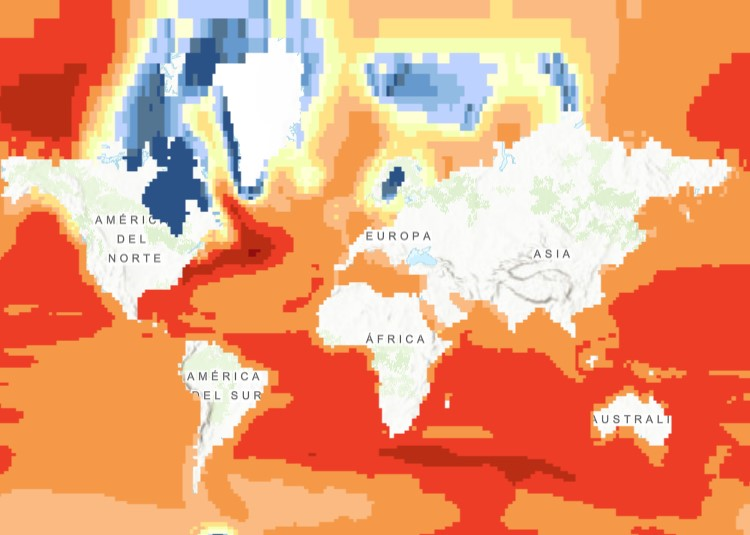
The raster dataset (1ºx1º) shows the projected change in relative sea level (in metres) in 2081-2100 compared to 1986-2005 for the medium-low emission scenario RCP4.5, based on an ensemble of Coupled Model Intercomparison Project Phase 5 (CMIP5) climate models. Projections consider land movement due to glacial isostatic adjustment but not land subsidence due to human activities. No projections are available for the Black Sea. The dataset has been used as a source for an earlier version of the EEA indicator “Global and European Sea Level”: https://www.eea.europa.eu/data-and-maps/indicators/sea-level-rise-5/assessment.