 Catalogue PIGMA
2008
Type of resources
Available actions
Topics
Keywords
Contact for the resource
Provided by
Years
Formats
Representation types
Update frequencies
status
Scale
Resolution
-
Auteur(s): Lehembre Adrien , Projet de reconversion d'un bâtiment industriel situé en centre ville touristique en un centre culturel intégrant médiathèque, librairie ainsi que d'un lieu d'exposition à Bergerac (Dordogne)
-
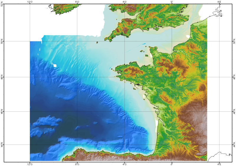
The Digital Terrain Model of the Bay of Biscaye and of the Channel is the result of the processing of a compilation of single and multibeam echosounder data, of DTMs and of chart countours produced before 2008 for hydrodynamic modeling..
-
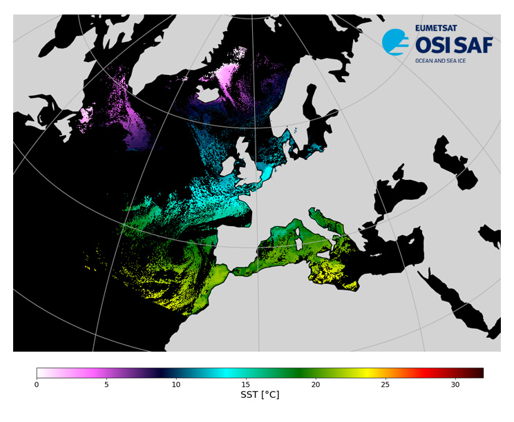
Level 3, four times a day, sub-skin Sea Surface Temperature derived from AVHRR on Metop satellites and VIIRS or AVHRR on NOAA and NPP satellites, over North Atlantic and European Seas and re-projected on a polar stereographic at 2 km resolution, in GHRSST compliant netCDF format. This catalogue entry presents Metop-A North Atlantic Regional Sea Surface Temperature. SST is retrieved from infrared channels using a multispectral algorithm and a cloud mask. Atmospheric profiles of water vapor and temperature from a numerical weather prediction model, Sea Surface Temperature from an analysis, together with a radiative transfer model, are used to correct the multispectral algorithm for regional and seasonal biases due to changing atmospheric conditions. The quality of the products is monitored regularly by daily comparison of the satellite estimates against buoy measurements. The product format is compliant with the GHRSST Data Specification (GDS) version 2.Users are advised to use data only with quality levels 3,4 and 5.
-
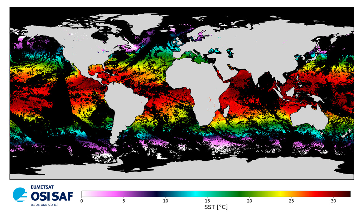
Level 3 twice-daily sub-skin Sea Surface Temperature derived from AVHRR on Metop-A, global and re-projected on a 0.05° regular grid, in GHRSST compliant netCDF format. The satellite input data has successively come from Metop-A and Metop-B level 1 data processed at EUMETSAT. SST is retrieved from AVHRR infrared channels (3.7, 10.8 and 12.0 µm) using a multi-spectral algorithm and a cloud mask. Atmospheric profiles of water vapor and temperature from a numerical weather prediction model, Sea Surface Temperature from an analysis, together with a radiative transfer model, are used to correct the multispectral algorithm for regional and seasonal biases due to changing atmospheric conditions.The quality of the products is monitored regularly by daily comparison of the satellite estimates against buoy measurements. The product format is compliant with the GHRSST Data Specification (GDS) version 2. Users are advised to use data only with quality levels 3, 4 and 5.
-
Cette enquête qualitative propose une lecture de la situation actuelle des usages, des représentations des agriculteurs aquitains d'une application de gestion de production de la Chambre Départementale d'Agriculture. Cette étude qualitative se déroule sous la forme d'entretiens semi-directifs. L'échantillon regroupe 25 exploitants, toute filière de production confondue, répartis sur le territoire aquitain (hors Lot et Garonne). Elle a été encadrée par Aurélie Laborde (maître de conférences et Responsable du Master "Stratégies et Produits de Communication" de l'ISIC) et menée par des étudiants de Master 1 "Communication des Organisations" (Nora Farhane, Amandine Richard, Sophie Serhouchni, Karen Toris et Mohamed Zarfani).
-
Recensement des sites web des hôtels en Aquitaine réalisé en 2008, par Franck Mérillou dans le cadre de son stage à AEC (Aquitaine Europe Communication) en liaison avec l'UMR 5185 ADES (Aménagement, Développement, Environnement, Santé et Sociétés) Université Michel de Montaigne Bordeaux 3 La Base de Données des sites web d'hôtels aquitains en 2008 concernait 475 sites. La Base de Données se compose de différents indicateurs : - Indicateurs d’identification : Nom de l’Hôtel, URL du Site, Code Commune (code INSEE permettant de localiser les sites Internet au niveau communal), Commune, Nombre d’étoiles (de 1 à 4 étoiles) - Indicateurs Qualitatifs : Dernière année de Mise à Jour, Choix de Langues (Allemand, Anglais, Espagnol, Italien, Néerlandais, Portugais, Autres Langues), Outils Cartographiques, éléments Audio, éléments Vidéo, Liens vers Hébergeurs, Disponibilités / Réservation / Paiement, Site Internet Propre / site Internet propre, Date de Création du Site (année), distinction entre les Hôtels et Hôtels/Restaurants, ne sont pas pris en compte les hôtels des grandes chaînes hôtelières ou les résidences de tourisme appartenant elles aussi à des chaînes (ils sont pris en compte que si ils possèdent un site propre).
-
Carte Communale (CC) numérisée. Ce lot informe du droit à bâtir sur la commune de SAINT-MICHEL-DE-DOUBLE. Cette CC est numérisée conformément aux prescriptions nationales du CNIG.
-
Carte communale de la commune de La Boissière d'Ans appartenant à la Communauté De Communes Causses et Vézère, version approuvée en 2008. Contient : Zonage + Rapport de présentation
-
Carte Communale (CC) numérisée. Ce lot informe du droit à bâtir sur la commune de CHAMPS-ROMAIN. Cette CC est numérisée conformément aux prescriptions nationales du CNIG.
-

Distribution des unités biosédimentaires. Cartes établies à partir des données historiques compilées par le REBENT