 Catalogue PIGMA
Simulation data
Type of resources
Available actions
Topics
Keywords
Contact for the resource
Provided by
Years
Formats
Representation types
Update frequencies
status
Scale
Resolution
-
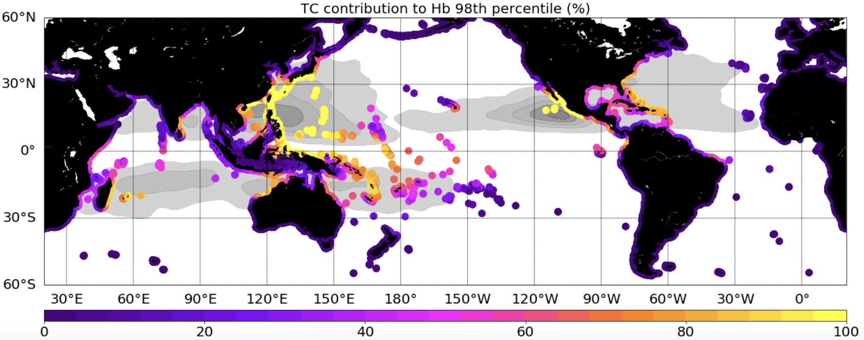
This dataset provides extreme waves (Hs: significant wave height, Hb:breaking wave height, a proxy of the wave energy flux) simulated with the WWIII model, and extracted along global coastlines. Two simulations, including or not Tropical Cyclones (TCs) in the forcing wind field, are provided.
-
Daily air-sea heat fluxes dataset on the last 27 years (1992-2018). Global coverage with 0.25° resolution. Data is mainly coming from aggregated calibrated scatterometer datasets and numerical models. Main geophysical parameters are: sensible heat flux, latent heat flux, wind speed, SST, air temperature. Latest version : 4.1 released in June 2019.
-
Global wave hindcast (1961-2020) at 1° resolution using CMIP6 wind and sea-ice forcings for ALL (historical), GHG (historical greenhouse-gas-only), AER (historical Anthropogenic-aerosol-only), NAT (historical natural only) scenario.
-
Wave hindcast based on WAVEWATCH III ® with parameterization from Romero (2019) adapted by Alday and Ardhuin (2023) as “TEST702”.
-

This dataset contains the outputs of nutrients concentrations of a global ocean simulation coupling dynamics and biogeochemistry at ¼° over the year 2019. The simulation has been performed using the coupled circulation/ecosystem model NEMO/PISCES (https://www.nemo-ocean.eu/), which is here enhanced to perform an ensemble simulation with explicit simulation of modeling uncertainties in the physics and in the biogeochemistry. This dataset is one of the 40 members of the ensemble simulation. This study was part of the Horizon Europe project SEAMLESS (https://seamlessproject.org/Home.html), with the general objective of improving the analysis and forecast of ecosystem indicators. See Popov et al. (https://os.copernicus.org/articles/20/155/2024/) for more details on the study.
-

This dataset contains some diagnostics of biology of a global ocean simulation coupling dynamics and biogeochemistry at ¼° over the year 2019. The simulation has been performed using the coupled circulation/ecosystem model NEMO/PISCES (https://www.nemo-ocean.eu/), which is here enhanced to perform an ensemble simulation with explicit simulation of modeling uncertainties in the physics and in the biogeochemistry. This dataset is one of the 40 members of the ensemble simulation. This study was part of the Horizon Europe project SEAMLESS (https://seamlessproject.org/Home.html), with the general objective of improving the analysis and forecast of ecosystem indicators. See Popov et al. (https://os.copernicus.org/articles/20/155/2024/) for more details on the study.
-
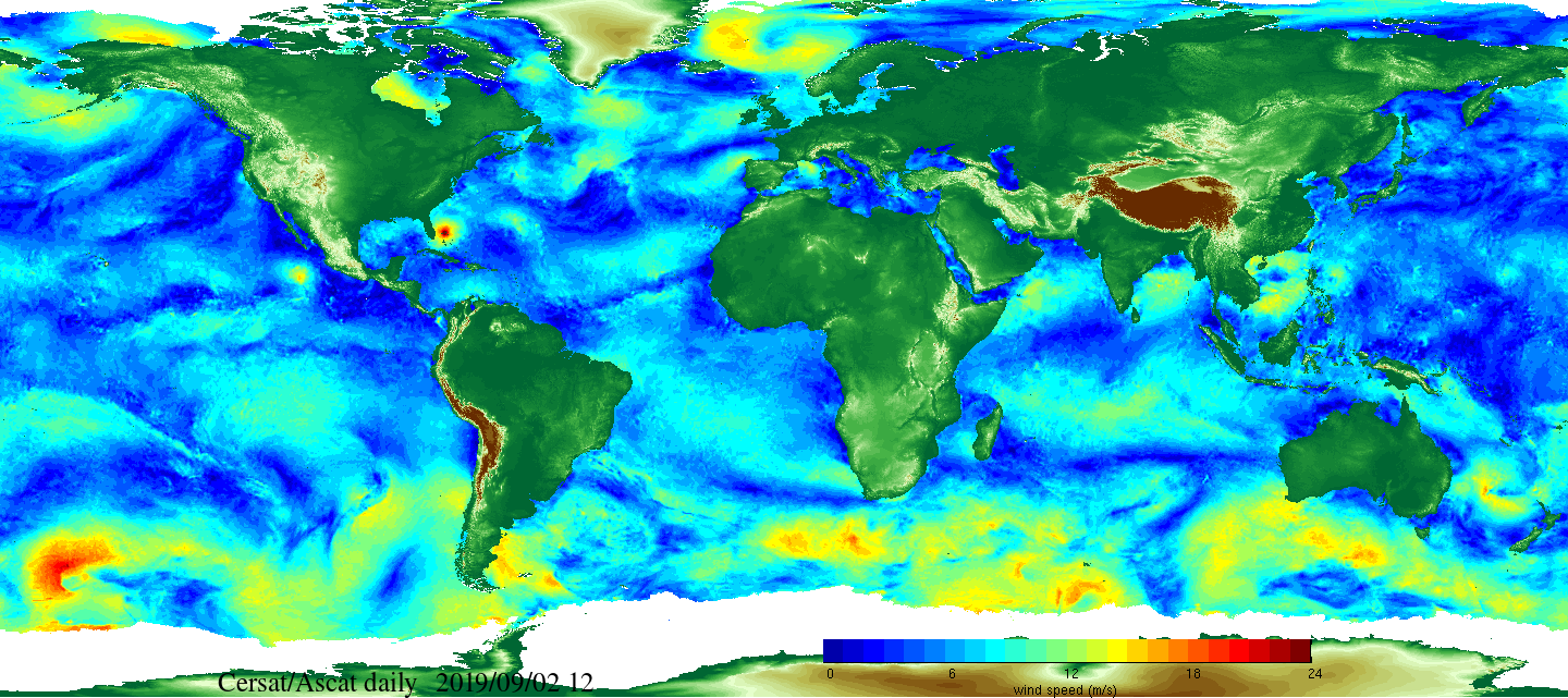
Daily and monthly surface wind analyses are determined as gridded wind products over global oceans, with regular spatial resolution of 0.25° in latitude and longitude. They are estimated from scatterometer wind retrievals (L2b data). According to the scatterometer sampling scheme, the objective method allowing the determination of regular in space surface wind fields uses remotely sensed observations as well as ECMWF analyses. The calculation of daily estimates uses ascending as well as descending available and valid retrievals. The objective method aims to provide daily-averaged gridded wind speed, zonal component, meridional component, wind stress and the corresponding components at global scale. The error associated to each parameter, related to the sampling impact and wind space and time variability, is provided too. Monthly wind analyses are calculated from daily estimates.
-
Hydrodynamic and sediment dynamic hindcast modelling with a resolution of 2.5 km in the Bay of Biscay and Channel, produced by coupling the hydrodynamic model CROCO with the sediment dynamic module MUSTANG.
-
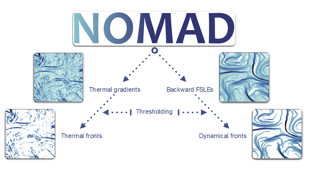
Fronts are ubiquitous discrete features of the global ocean often associated with enhanced vertical velocities, in turn boosting primary production and so forth. Fronts thus form dynamical and ephemeral ecosystems where numerous species meet across all trophic levels. Fronts are also targeted by fisheries. Capturing ocean fronts and studying their long-term variability in relation with climate change is thus key for marine resource management and spatial planning. The Mediterranean Sea and the Southwest Indian Ocean are natural laboratories to study front-marine life interactions due to their energetic flow at sub-to-mesoscales, high biodiversity (including endemic and endangered species) and numerous conservation initiatives. Based on remotely-sensed Sea Surface Temperature and Height, we compute thermal fronts (2003-2020) and attracting Lagrangian Coherent Structures (1994-2020), in both regions over several decades. We advocate for the combined use of both thermal fronts and attracting Lagrangian Coherent Structures to study front-marine life interactions. The resulting front database differs from other alternatives by its high spatio-temporal resolution, long time coverage, and relevant thresholds defined for ecological provinces.
-
IOWAGA sea-states hindcast database generated by the wave model WAVEWATCH-III and forced by CFSR winds on the North East Atlantic grid over 1990-2012 period.