 Catalogue PIGMA
WP4 Benthic Mapping
Type of resources
Available actions
Topics
Keywords
Contact for the resource
Provided by
Years
Formats
Representation types
Update frequencies
status
Scale
Resolution
-

Ireland’s Marine Atlas is developed and maintained by the Marine Institute with funding by the Government of Ireland. This work is part supported by the Irish Government and the European Maritime & Fisheries Fund as part of the EMFF Operational Programme for 2014-2020. The atlas provides a one-stop-shop to view and download marine environmental data relevant to reporting under Ireland’s Marine Strategy Framework Directive (MSFD). The aim of the European Union’s MSFD directive is to protect more effectively the marine environment across Europe through the establishment of “good marine waters”. Data in Ireland’s Marine Atlas has been guided by the European Directive on harmonising environmental data across Europe within a spatial data infrastructure known as INSPIRE. INSPIRE Data Specifications (Data Models) have been used to manage data to the categories visible under THEMES in the atlas. Many of the layers displayed in the Atlas are also used in the National Marine Planning Framework (NMPF). This framework aims to bring together all marine-based human activities, outlining the government’s vision, objectives and marine planning policies for each marine activity. The NMPF report details how these marine activities will interact with each other in an ocean space that is under increasing spatial pressure, ensuring the sustainable use of our marine resources to 2040. Please read the following information carefully as it sets out the terms and conditions that govern the use of products and services on this website. Once you have read these terms and conditions click the "Agree" button at the bottom of the page to proceed. By clicking the "Agree" button you will be deemed to have accepted the terms and conditions, our legal notices and privacy statement.
-

Infield Systems, now part of Wood Mackenzie (for the full news story please follow this link), is an energy research and analysis firm that is dedicated to the provision of accurate and up-to-date information, databases, research, market forecasts, mapping, commercial market due-diligence, transaction support, business strategy, analysis and intelligence to the global offshore oil, gas, renewable energy and associated marine industries. Over the past 25 years Infield Systems has developed an extensive range of products and services to assist industry professionals, analysts and investors with their business and investment decisions. Within its core markets, Infield Systems has become widely acknowledged as one of the definitive resources of information, research and analysis. Infield Systems services clients from a wide range of organisations including exploration and production companies, service suppliers, offshore contractors, manufacturers, government agencies, financial institutions and investors. In addition Infield provides information, analysis and commentary for the energy trade press and at industry conferences through presentation of papers and keynote speeches. Products and services are broadly divided into the following key areas: - Data Services - Research - Business Strategy & Analysis - Transaction Services
-

This is a compilation of OSPAR habitat point data for the northeast Atlantic submitted by OSPAR contracting parties. The compilation is coordinated by the UK's Joint Nature Conservation Committee, working with a representative from each of the OSPAR coastal contracting parties. This public dataset does not contain records relating to sensitive species (e.g. Ostrea edulis) in specific areas, or where data are restricted from public release by the owner's use limitations. This version (v2020) was published in July 2021.
-
NASA's OceanColor Web is supported by the Ocean Biology Processing Group (OBPG) at NASA's Goddard Space Flight Center. Our responsibilities include the collection, processing, calibration, validation, archive and distribution of ocean-related products from a large number of operational, satellite-based remote-sensing missions providing ocean color, sea surface temperature and sea surface salinity data to the international research community since 1996. As a Distributed Active Archive Center (DAAC), known as the Ocean Biology DAAC (OB.DAAC), we are responsible for the archive and distribution of satellite ocean biology data produced or collected under NASA EOSDIS, including those from historical missions and partner space organizations.
-
EMODnet Biology provides three keys services and products to users. 1)The data download toolbox allows users to explore available datasets searching by source, geographical area, and/or time period. Datasets can be narrowed down using a taxonomic criteria, whether by species group (e.g. benthos, fish, algae, pigments) or by both scientific and common name. 2) The data catalogue is the easiest way to access nearly 1000 datasets available through EMODnet Biology. Datasets can be filtered by multiple parameters via the advanced search from taxon, to institute, to geographic region. Each of the resulting datasets then links to a detailed fact sheet containing a link to original data provider, recommended citation, policy and other relevant information. Data Products - EMODnet Biology combines different data from datasets with overlapping geographic scope and produces dynamic maps of selected species abundance. The first products are already available and they focus on species whose data records are most complete and span for a longer term.
-
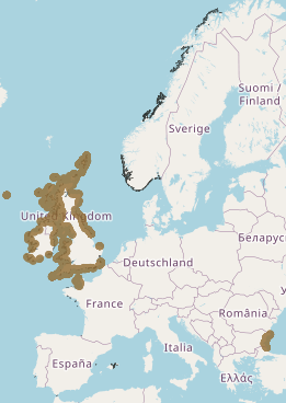
This layer shows the current known extent and distribution of macroalgal canopy in European waters, collated by EMODnet Seabed Habitats. The polygons portion was last updated in 2019. The points were added in Sept 2021. The purpose was to produce a data product that would provide the best compilation of evidence for the essential ocean variable (EOV) known as Macroalgal canopy cover and composition (sub-variable: Areal extent), as defined by the Global Ocean Observing System (GOOS). Kelp and fucoid brown algae are the dominant species that comprise macroalgal forests. This data product should be considered a work in progress and is not an official product.
-
Intermediate Assessment 2017 - Seabed Litter - Litter is widespread on the seafloor across the area assessed, with plastic being the predominant material encountered. In the areas assessed, higher amounts of litter are found in the Eastern Bay of Biscay, Southern Celtic Seas and English Channel relative to the north of the Greater North Sea and Celtic Seas.
-
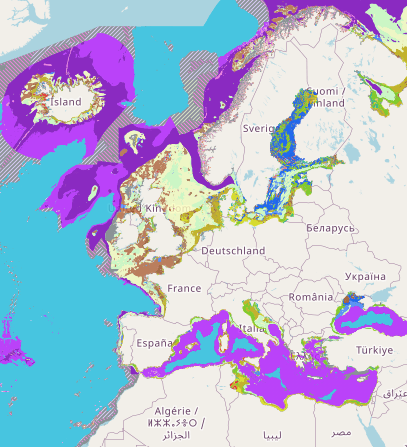
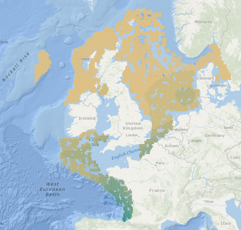
Output of the 2019 EUSeaMap broad-scale predictive model, produced by EMODnet Seabed Habitats and aggregated into the Benthic Broad Habitat Types of the Marine Strategy Framework Directive (as defined in the Commission Decision 17 May 2017). The extent of the mapped area includes the Mediterranean Sea, Black Sea, Baltic Sea, and areas of the North Eastern Atlantic extending from the Canary Islands in the south to the Barents Sea in the north. The map was produced using a "top-down" modelling approach using classified habitat descriptors to determine a final output habitat. Habitat descriptors differ per region but include: - Biological zone - Energy class - Oxygen regime - Salinity regime - Seabed substrate - Riverine input Habitat descriptors (excepting Substrate) are calculated using underlying physical data and thresholds derived from statistical analyses or expert judgement on known conditions.
-
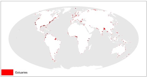
This dataset shows the global distribution of over 1,300 estuaries, including some lagoon systems and fjords. The majority of estuaries are represented by polygons, except for 44 records for which points are available. This dataset was developed by Sea Around Us (www.seaaroundus.org).
-
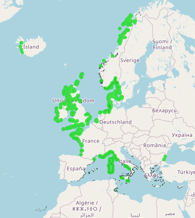
This layer shows the current known extent and distribution of Seagrass meadows in European waters, collated by EMODnet Seabed Habitats. The polygons portion was last updated in 2019. The points were added in Sept 2021. The purpose was to produce a data product that would provide the best compilation of evidence for the essential ocean variable (EOV) known as Seagrass cover and composition (sub-variable: Areal extent of seagrass meadows), as defined by the Global Ocean Observing System (GOOS). Seagrasses provide essential habitat and nursery areas for many marine fauna. There are approximately 72 seagrass species that belong to four major groups: Zosteraceae, Hydrocharitaceae, Posidoniaceae and Cymodoceaceae. Zostera beds and Cymodecea meadows are named on the OSPAR Threatened or Declining Habitats list. Posidonia beds are protected under Annex I of the EU Habitats Directive. This data product should be considered a work in progress and is not an official product.