 Catalogue PIGMA
300000
Type of resources
Available actions
Topics
Keywords
Contact for the resource
Provided by
Years
Formats
Representation types
Update frequencies
status
Scale
-

Communes de Charente éligibles au programme Petites Villes de Demain. Petites villes de demain vise à améliorer les conditions de vie des habitants des petites communes et des territoires alentour, en accompagnant les collectivités dans des trajectoires dynamiques et respectueuses de l’environnement. Le programme a pour objectif de donner aux élus des villes et leurs intercommunalités de moins de 20 000 habitants exerçant des fonctions de centralités les moyens de concrétiser leurs projets de territoire.
-

Communes de la Charente ayant procédé à la mise en conformité de leur adressage des voies et numéros d'immeubles via le SIG Départemental. L’Agence technique de la Charente (ATD16) accompagne les communes qui en ont fait le choix, sur la réalisation et la création de leur adresses en créant une Base Adresse Locale (BAL).
-
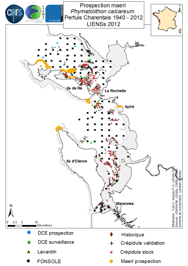
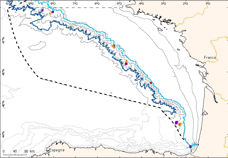
Un inventaire des bancs de maerl, algues rouges marines Corallinacées à thalles calcifiés arbusculaires et non fixés, est réalisé dans les Pertuis Charentais grâce à la compilation de données historiques et de nouvelles observations sur la période 2006-2012. L’emprise géographique de l’inventaire englobe les Pertuis Breton, d’Antioche et de Maumusson, s’étend de l’estuaire du Lay au Nord à la baie de Marennes-Oléron au Sud et inclut les pourtours des îles de Ré, d’Oléron et d’Aix. Sont contributrices à cet inventaire, les prospections DCE 2006, les contrôles de surveillance DCE 2007 à 2012 sous l’égide d’Ifremer et des Agences de l’Eau Loire-Bretagne et Adour-Garonne, les prospections réalisées pour le Port Atlantique La Rochelle sur le site de dépôts de dragage du Lavardin de 2007 à 2012, les prospections 2007 FONSOLE d’Ifremer et les prospections d’Ifremer et du laboratoire LIENSs en vue de cartographier les stocks de crépidules en mer des Pertuis Charentais. S’ajoutent des prospections spécifiques réalisées en 2011 à bord du navire Estran par benne sur les fonds sédimentaires infralittoraux du Pertuis Breton et par cadrat en zone intertidale en 2012 sur les pourtours des îles de Ré, d’Oléron et le long des falaises d’Aytré. Le positionnement des stations de vérité terrain ont eu lieu par relevés GPS ou dGPS. Repéré initialement par des prélèvements à la benne en octobre 2009 lors de la validation de prospections sonar pour individualiser les stocks de crépidules, un banc de maerl vif est cartographié en juillet 2011 en rade de Saint-Martin dans le Pertuis Breton. Sa superficie est estimée à plus de 2 km². Des prospections pedibus jambi réalisées à la pointe du Grouin et à Saint-Martin de Ré ont permis de confirmer la présence de maerl vif épars sur le bas des estrans. Cela suggère un éparpillement des thalles de maerl vif sur plusieurs dizaines de km² autour du banc principal de Saint-Martin. Est aussi confirmé l’unique relevé algologique de Phymatolithon calcareum fait au début du XXème siècle à Saint-Martin de Ré par Dollfus, probablement déjà en bas d’estran comme observé en 2012 à proximité de la balise du Couronneau. De très nombreux thalles de maerl mort en voie de diagénèse ont aussi été observés dans l’Est et le Sud-Est des Pertuis Breton et d’Antioche suggérant des apports par transports passifs issus de bancs vivants situés plus à l’Ouest, y compris dans le Pertuis d’Antioche. La présence de maerl vif sur le bas des estrans est en effet connue très ponctuellement dans l’Ouest des îles d’Oléron (Pointe de Chassiron) et de Ré (Phare des Baleines) via des relevés algologiques et faunistiques récents. Sur le plan biogéographique, le banc de maerl du Pertuis Breton est le plus oriental et le plus méridional de ceux connus dans le Golfe de Gascogne. Les bancs de maerl connus les plus proches sont respectivement situés à Noirmoutier (baie de Bourgneuf) et en Galice (Espagne). Ces observations complètent l’atlas cartographique des populations de maerl en Europe édité sous l’égide de la convention OSPAR. Elles apportent une base de connaissances pour les futures actions de conservation à définir localement dans le contexte Natura 2000 en mer du Parc Naturel Marin de l’estuaire de la Gironde et des Pertuis charentais.
-
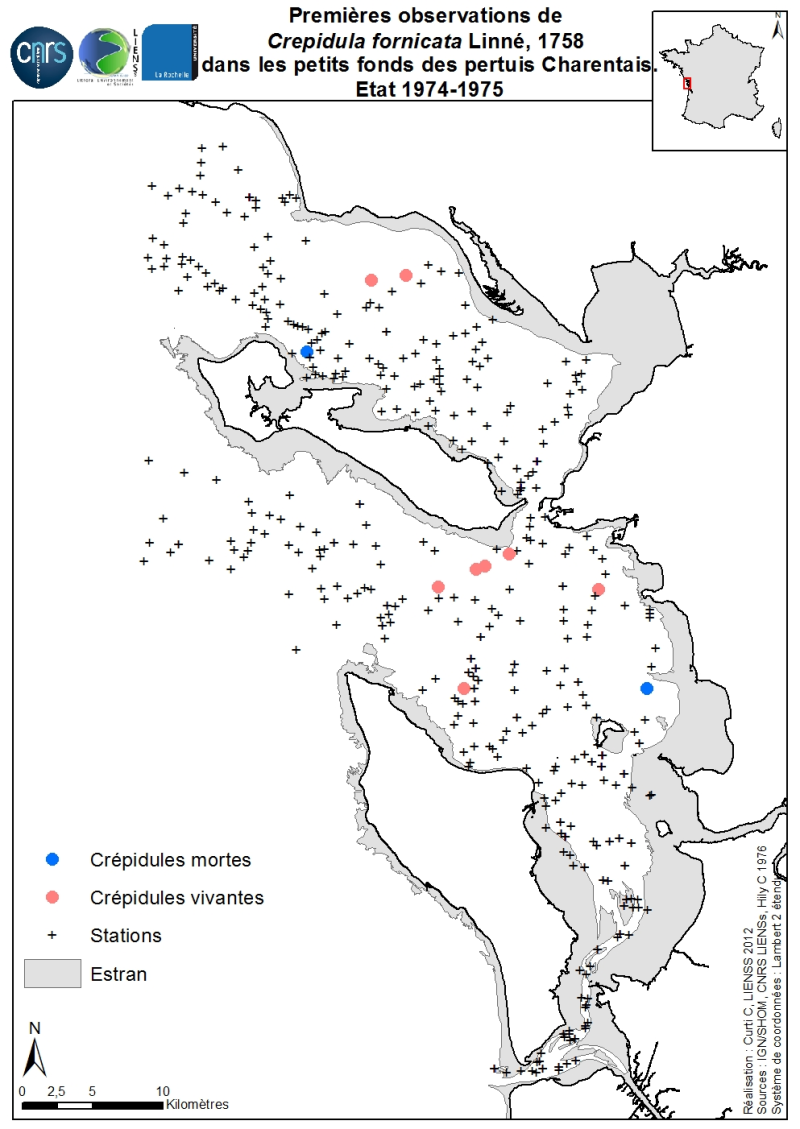
Les premières observations historiques de la crépidule Crepidula fornicata Linné, 1758 sur les petits fonds des Pertuis Charentais ont été cartographiées suite à un réexamen des résultats bruts obtenus par C. Hily lors de ses travaux de thèse de 3ème cycle sur l’écologie benthique des Pertuis Charentais. Les prélèvements ont été réalisés soit à la benne Smith McIntyre soit à la drague Rallier du Baty à bord du NO/Armorique de Concarneau en deux périodes, juin à août 1974 (432 prélèvements dont 330 quantitatifs) et avril 1975 (98 prélèvements dont 50 quantitatifs). Cette carte est issue de résultats inédits non référencés dans la thèse de C. Hily (1976) « Ecologie benthique des pertuis charentais». L’échantillonnage de l’ensemble de ces 528 prélèvements est limité à la zone infralittorale et circalittorale en excluant la zone intertidale. Cinq prélèvements quantitatifs à la benne Smith-McIntyre (dite « Aberdeen ») se révèlent contenir des crépidules vivantes entre 1 et 3 individus par benne de 0,1 m². Trois prélèvements qualitatifs par la drague Rallier du Baty se révèlent contenir chacun 1 crépidule vivante. Deux prélèvements quantitatifs contiennent des crépidules mortes, entre 1 et 5 par benne.
-
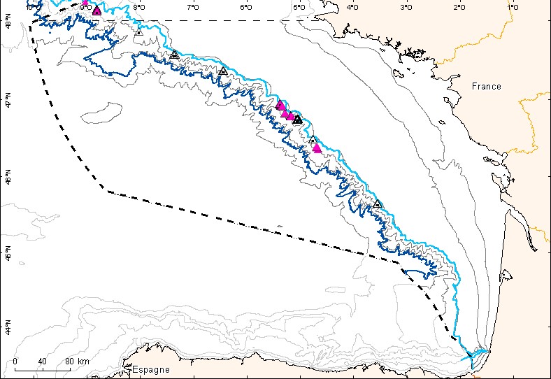
Couche de points représentant les observations d'habitats particuliers des mers celtiques et du Golfe de Gascogne depuis le début du XXème siècle.
-

A la demande de l’Agence des Aires Marines Protégées, un inventaire cartographique des habitats des sites Natura 2000 en mer de l’estuaire de la Gironde et des Pertuis charentais a été réalisé afin d’établir un état initial de référence des milieux naturels. Est ici présenté l’inventaire cartographique dévolu aux zones intertidales meubles et rocheuses des Pertuis Charentais comprenant le littoral depuis la Tranche sur Mer jusqu’à Bonne Anse. S’inspirant des protocoles REBENT et MESH, trois méthodes complémentaires ont été combinées pour cartographier ces habitats intertidaux (Cajeri et al., 2012). Elles combinent les inventaires terrain avec relevés GPS différentiel, la télédétection couplant analyse d’ortho littorales et de scènes du satellite KOMPSAT-2 puis l’intégration sous système d’information géographique (SIG). Le rendu cartographique est basé sur la typologie EUNIS de niveau 4. Les structures délimitées sur photographies aériennes et validées par les inventaires terrain sont interprétées à partir de scènes satellite soumises à classification hiérarchique permettant une discrimination en termes de nature de sol, type de végétation et présence de mares. La compilation des informations est réalisée sous SIG en respectant les contraintes d’échelle et de topologie. Cette étude permet de combler un vide majeur de connaissances en particulier pour les habitats rocheux et les habitats d’espèces dans les Pertuis Charentais, les habitats de substrats meubles ayant été décrits par Hily (1976) et interprétés en typologie EUNIS par le REBENT. La carte proposée des habitats intertidaux n’est cependant pas définitive. Elle devrait bénéficier d’ajouts apportés à la typologie EUNIS par l’incorporation de nouveaux habitats en cours de validation à l’échelle européenne.
-
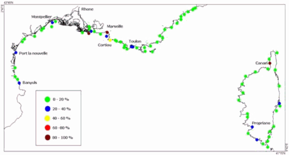
Toxicité des sédiments
-
Couche de points représentant les observations d'habitats vulnérables des fonds meubles des mers celtiques et du Golfe de Gascogne depuis le début du XXème siècle.
-
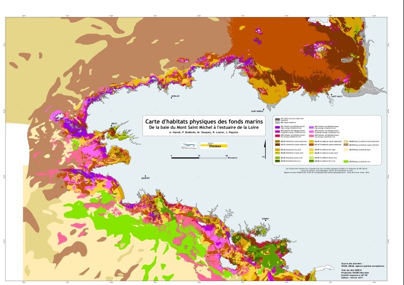
Habitats physiques dans la typologie Eunis résultant du croisement de trois variables physiques maillées à la résolution de 100 mètres : nature du substrat, zone biologique, tension de cisaillement au fond. Côtes de France métropolitaine. Rapport Ifremer "Hamdi Anouar, Vasquez Mickael, Populus Jacques (2010). Cartographie des habitats physiques Eunis - Côtes de France. Convention Ifremer/AAMP n° 09/12177764/FY. http://archimer.ifremer.fr/doc/00026/13751/ "
-
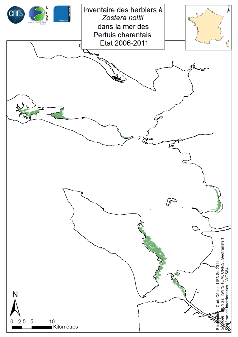
Un inventaire des herbiers de Zostera noltii Hornemann, 1832 est réalisé pour l’ensemble des estrans de la mer des Pertuis charentais à partir d’une synthèse des observations disponibles de 2006 à 2011. L’emprise géographique s’étend de l’estuaire du Lay à la baie de Marennes-Oléron et inclut les îles de Ré, d’Oléron et d’Aix. Sont contributrices les données issues des prospections DCE 2006, contrôles de surveillance DCE 2007 (sous l’égide d’Ifremer et des Agences de l’Eau Loire-Bretagne et Adour-Garonne), des cartographies 2010 et 2011 Natura 2000 réalisées par LIENSs, IODDE et Ré nature Environnement pour l’AAMP et d’une analyse des Orthophotos disponibles pour des sites anciennement prospectés par les gestionnaires de réserves naturelles de la LPO en Charente-Maritime. Les méthodes utilisées vont de l’analyse d’images du satellite SPOT (réalisée par BioLittoral et Géotransfert) à la photo-interprétation (réalisée par LIENSs) mais dans chacun des sites prospectés, des vérités terrain ont eu lieu (réalisées par LIENSs, IODDE, Ré Nature-Environnement) afin de dresser l’extension des herbiers par relevés GPS ou dGPS. Les plus grands herbiers de cet inventaire sont présentés par Auby et al. (2010a, b) dans le volume des annexes (p. 29 pour les Pertuis charentais y compris la baie de Marennes-Oléron, p.44 pour le Pertuis breton y compris l’île de Ré et p. 141 pour l’estuaire du Lay). Les informations cartographiques pour le Nord de l’île de Ré, la baie d’Yves, le Sud de l’île d’Aix et le Nord de l’île d’Oléron viennent en complément et permettent de dresser un inventaire probablement exhaustif de la présence des herbiers de Zostera noltii de nos jours pour l’ensemble de la mer des Pertuis charentais. Un inventaire similaire est dressé pour Zostera marina dont quelques populations subsistent de nos jours sur les estrans Sud et Ouest de l’île de Ré (Le Gall, 2005).