 Catalogue PIGMA
utilitiesCommunication
Type of resources
Available actions
Topics
Keywords
Contact for the resource
Provided by
Years
Formats
Representation types
Update frequencies
status
Service types
Scale
Resolution
-

Particuliers bénéficiant du portage de repas à domicile
-

Historiquement l'Agence Technique Départementale a été créée pour accompagner les maîtres d'ouvrage dans la réalisation des bâtiments ou infrastructures communaux. Elle a depuis développé un savoir-faire particulier grâce à une équipe technique performante pour accompagner les élus dans l'aide à la décision ou plus largement dans les réflexions à mener sur leur territoire. Aujourd'hui, avec le désengagement progressif des services d'ingénierie de l'Etat, l'ATD permet de conserver pour les collectivités Territoriales qui y adhèrent une offre d'ingénierie publique Territoriale compétente. Les missions statutaires constituées par les études de faisabilité ou de simple diagnostic sont désormais complétées par des missions d'assistance technique en phase pré-opérationnelles réalisées uniquement dans le cadre de prestations intégrées. L'ensemble de ces missions reste strictement circonscrit dans la sphère du maître d'ouvrage, l'ATD n'assurant pas de mission de maîtrise d'œuvre.
-

Communes de Charente éligibles au programme Petites Villes de Demain. Petites villes de demain vise à améliorer les conditions de vie des habitants des petites communes et des territoires alentour, en accompagnant les collectivités dans des trajectoires dynamiques et respectueuses de l’environnement. Le programme a pour objectif de donner aux élus des villes et leurs intercommunalités de moins de 20 000 habitants exerçant des fonctions de centralités les moyens de concrétiser leurs projets de territoire.
-
Ensemble de données permettant de matérialiser les différents éléments constituant un plan de cimetière communal. Limites de cimetière, Murs, Clôtures, Espace verts Emplacements, Monuments, Allées, Secteurs Bâtiments, Points d'eaux, déchets, etc... Ces données sont intégrées au SIG Départemental mis en œuvre par l'ATD16 permettant aux communes de gérer leurs concessions de cimetière via un logiciel métier.
-

Zone arrière du point de mutualisation (ZAPM) des territoires gérés par la SPL NATHD non déployées
-
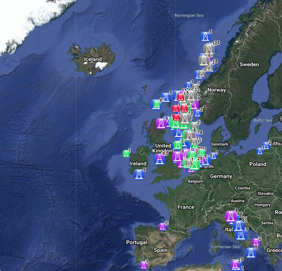
The dataset on offshore installations for Oil and Gas exploitation and exploration activities was created in 2015 by Cogea for the European Marine Observation and Data Network (EMODnet). It is the result of the aggregation and harmonization of datasets provided by several EU and non-EU sources. It is updated every year, and is available for viewing and download on EMODnet - Human Activities web portal (www.emodnet-humanactivities.eu). The dataset contains points representing offshore installations and where available each point has the following attributes: ID, name, country, location block, operator, production start year, primary production, current status, category and function of the installation, sub-structure and topside weights (tonnes), water depth (metres), distance to coast (metres) and remarks. The OSPAR commission source covers data for Germany, Ireland, Spain and the United Kingdom, while for Italy data have been collected and harmonized from the Italian Ministry of Economic Development, for Norway from the Norwegian Petroleum Directorate, for Denmark from the Danish Energy Agency, for the Netherlands from the TNO - Geological Survey of the Netherlands, for Croatia from the Croatian Hydrocarbon Agency, from Marine Traffic and Helcom data on Polish and Russian installations in the Baltic Sea, from Marine Traffic data on Bulgarian, Russian and Ukrainian installations in the Black Sea, Lybian and Spanish installations in the Mediterranean Sea. Compared with the previous version this new version has been updated for all countries.
-

Gestion de la taxe de séjour des Établissements Touristiques aux réels (montant/suivi déclaration/suivi facturation) à l'échelle des communautés de communes.
-
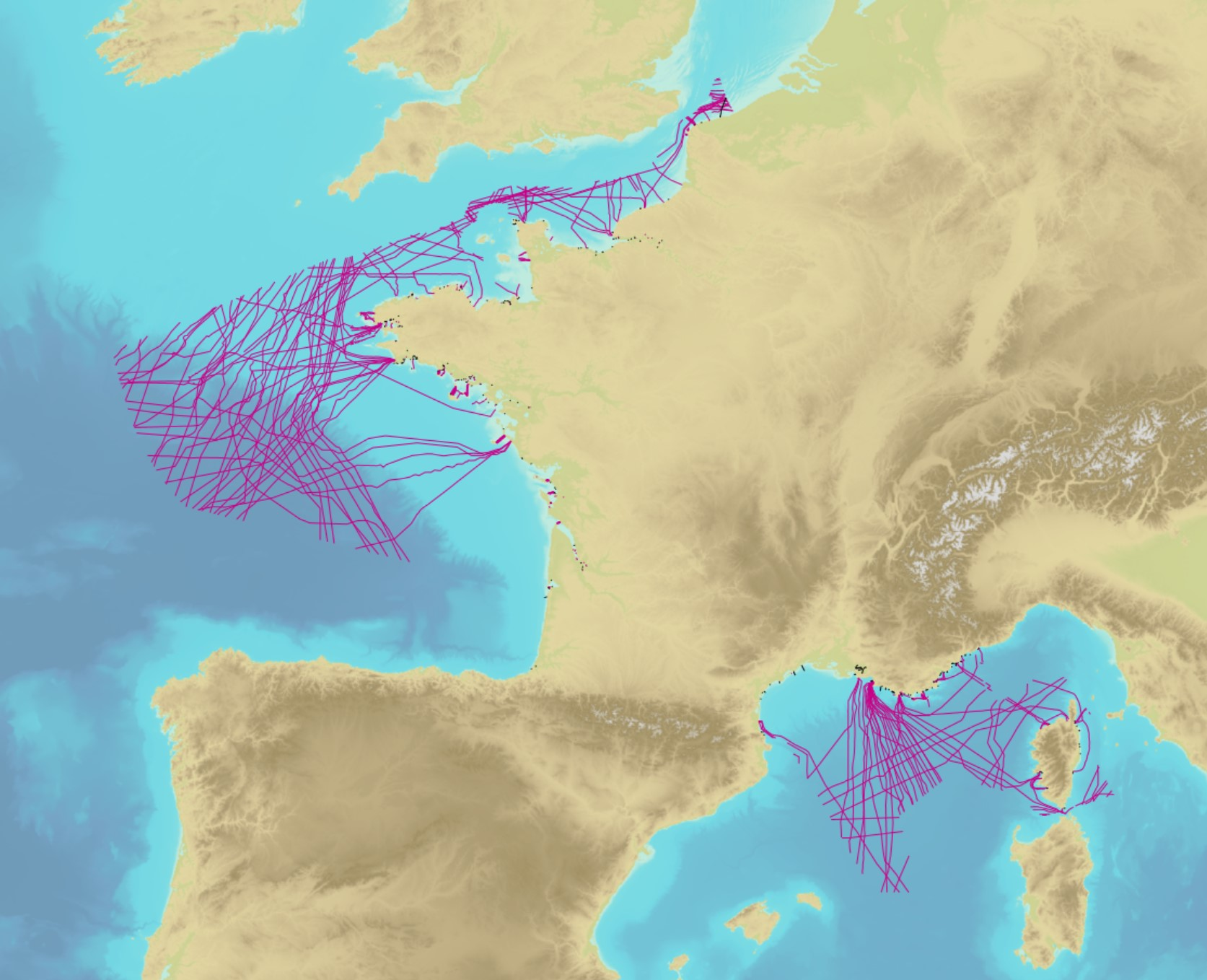
The product contains a description of submarine cables and pipelines brought to the attention of Shom on French areas of responsibility. These are 2D linear objects of the seabed that divide into two categories: • The submarine cables: these are cables placed on the seabed where electricity or information (telecommunication) flows. They represent the vast majority of objects (more than 90%); • Emissaries and submarine pipes: these are pipes that allow the discharge, sampling or circulation of fluids.
-
Réseau TERÉGA (ex-TIGF) sur le département des Landes. Servitudes s'appliquant aux canalisations de transport de gaz ainsi que le linéaire de réseau abandonné.
-

Prises IPE présentes sur les territoires gérés par la SPL NATHD