 Catalogue PIGMA
TXT
Type of resources
Available actions
Topics
Keywords
Contact for the resource
Provided by
Years
Formats
Representation types
Update frequencies
status
-
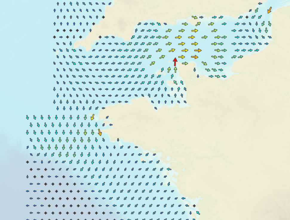
This product includes all Shom digital files for tidal currents on mainland French coasts (Channel and Atlantic coasts) in mesh format. These digital files indicate surface tidal current components, hour by hour and for two typical tidal coefficients (45 and 95) and maximum current speeds for a mean spring tide. Brest is taken as the reference port for viewing purposes. The current points included in these files correspond to the arrows shown on current atlases.
-

Unveiling the implications of hybridization on fitness stands as a primary focus in the realms of ecology and evolution. Numerous investigations elucidate how evolutionary mechanisms regulate the intricate pattern of introgression across genomes, yet few have examined the consequential impact of genetic admixture on fitness attributes. Leveraging the Western Mediterranean population of the European seabass (Dicentrarchus labrax), a population formed through hybridization of the Atlantic and Mediterranean lineages in the Alboran Sea, we utilized the Axiom Sea Bass 57k SNP DlabChip array to genotype 1850 hybrid individuals. This enabled us to evaluate the correlation between individual admixture levels and fitness traits under varying thermal conditions (19°C, 21°C, 23°C, and 25°C). Our initial findings unveil a male-biased sex ratio and high temperature sensitivity among admixed individuals with a greater proportion of Atlantic ancestry. Subsequently, our analysis demonstrates that individuals with a higher Atlantic genetic background also exhibit reduced body weight (a parameter linked to fecundity in fish) compared to those with lower Atlantic ancestry. These outcomes underscore the disadvantageous nature of Atlantic ancestry introgression in the Mediterranean region, aligning with previous observations of the elimination of Atlantic ancestry segments subsequent to hybridization.
-
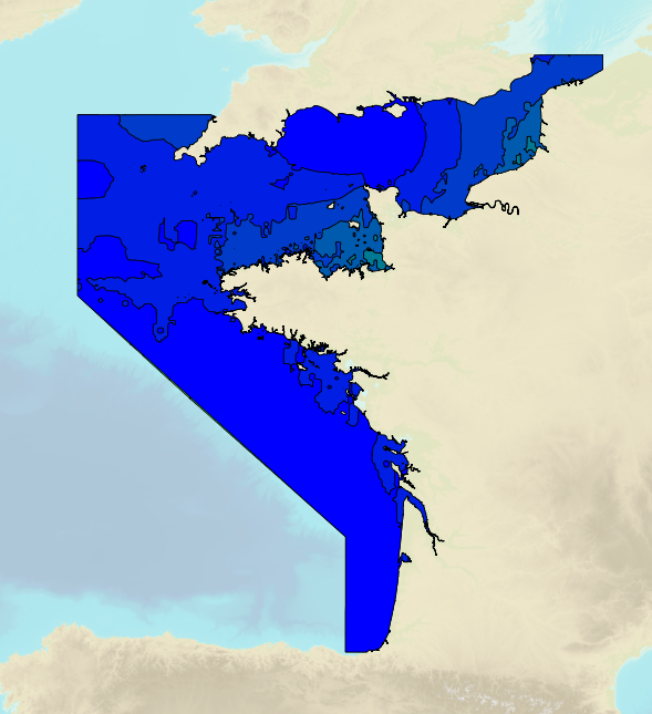
Tidal ranges on the French coasts of the Channel and the Atlantic for a coefficient of 95 : tidal range for mean neap tides for average atmospheric conditions..
-
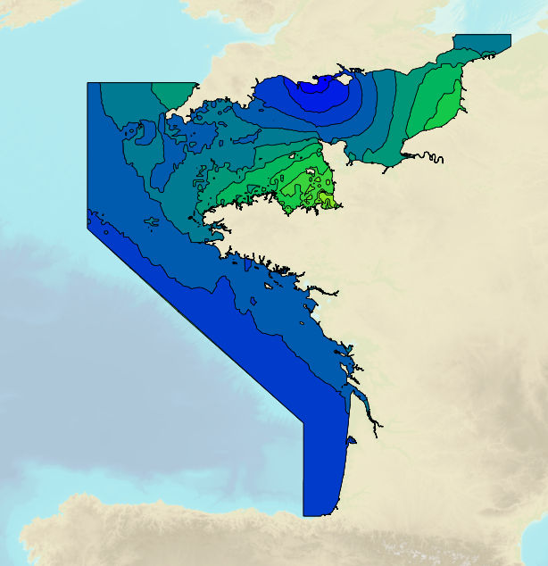
Tidal ranges on the French coasts of the Channel and the Atlantic for a coefficient of 20 : minimum tidal range for average atmospheric conditions..
-
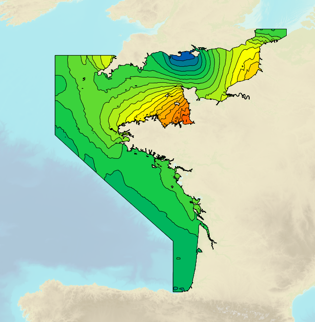
Tidal ranges on the French coasts of the Channel and the Atlantic for a coefficient of 95 : tidal range for mean spring tides for average atmospheric conditions..
-
Tidal ranges on the French coasts of the Channel and the Atlantic for a coefficient of 95 : maximal tidal range for average atmospheric conditions..
-
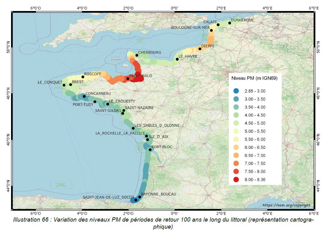
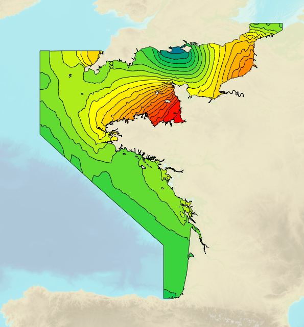
This study provides an initial global estimate of the extreme water level values along the French metropolitan coastline. These results are to be refined locally with all available data and knowledge. The method used is based on a statistical analysis of the tide gauge observations available in the ports. It does not take into account wave observations. The results between ports are obtained by an interpolation method. The study produces at the reference ports the statistical estimates: - extreme values of high water surge in the Channel and Atlantic; - extreme values of water level for the whole of Metropolitan France. And a set of statistical estimation maps of extreme water level values along the coastline. The estimates provided go up to the 1,000-year return period. In view of the duration of observations used at the ports, the user must check whether estimates with a return period of more than 50 or 100 years are still valid 50 or 100 years still make sense.
-

Shom manages a network of permanent digital coastal tide-gauges on French coasts: the RONIM Sea Level Observation Network. Most tide-gauge observatories are partnered with one or more local partners.<br /><br /> Four main types of data are available for download:<br /> - “Raw high frequency" data: raw observations neither validated nor evaluated, obtained directly from the sensor. 1-minute measurement; integration time 15 seconds (on the minute); sampling period: 1 second.<br /><br /> - "Raw non-real time" data: raw observations neither validated nor evaluated, obtained directly from the sensor. 10-minute measurement; integration time 121 seconds (around every 10 minutes); sampling period: 1 second.<br /><br /> - "Validated non-real time" data: observations checked and validated by Shom from the "Raw non-real time" data. 10-minute measurement; integration time 121 seconds (around every 10 minutes); sampling period: 1 second.<br /><br /> - "Validated hourly" data: observations checked and validated by Shom, generated from "Validated non-real time" data. Hourly measurement obtained from the Vondrak filter with triangular weighting. The hourly height cannot be calculated in the event of an observation gap greater than 1.5 hours.
-
Shom is the national referent for the level of the sea in situ on all areas under French jurisdiction. In this capacity, he assures under the acronym REFMAR different coordination functions in the collection and dissemination of public data related to water level observations, in order to promote their use in multiple applications within the framework of international recommendations.