 Catalogue PIGMA
tableDigital
Type of resources
Available actions
Topics
Keywords
Contact for the resource
Provided by
Years
Formats
Representation types
Update frequencies
status
Scale
Resolution
-

Digital Surface Models (DSMs) of the study area were generated by drones on 19 September 2024 and 18 September 2025. Each pixel represents the elevation value of the terrain at the time of the survey. These DSMs were generated from 895 (2024) and 1,282 images (2025), captured at an altitude of 120 (2024) and 100 meters (2025) using the DJI Mavic 3E RTK and Mavic 3M RTK drones, with ground resolutions of 3.19 (2024) and 2.63 cm/pixel (2025). The surveyed area covers approximately 1 km². The DSMs were resampled to a resolution of 20 cm. The vertical coordinate system used is NGF IGN69.
-

Digital Surface Models (DSMs) of the study area surveyed by drone between June 2024 and March 2025. Each pixel contains the elevation value corresponding to the terrain at the time of the mission. These DSMs were generated from around 1,300 images (depending of the survey) acquired using the DJI Mavic 3E RTK drone, with a resolution of 3.2 cm/pixel. The surveyed area covers around 2.1 km². The campaign was conducted on the highest tides of each month. The drone acquisitions were carried out by Nicolas Lachaussée from the LIENSs UMR Drone Platform. Photogrammetric processing was performed by Natacha Volto (LIENSs) using Agisoft Metashape software. The vertical coordinate system is NGF IGN69. The vertical accuracy (RMSD ~ 3 cm), calculated using around 100 control points, randomly distributed across the study area. It is derived from the vertical difference for each control point between the value measured with the DGPS SP80 and the value extracted from the photogrammetry-generated DSM. These drone surveys were carried out as part of the thesis of Loës Le Goff Le Gourrierec supervised by Xavier Bertin.
-

The multispectral images of the study area were acquired by drone on 18 September 2025 using the DJI Mavic 3M RTK. The orthomosaic was generated from 5,128 images across five spectral bands (Green, Red, Red Edge, Near-Infrared (NIR), and Alpha), captured at an altitude of 100 meters (2025). The ground resolution achieved was 4.568 cm/pixel, covering a surveyed area of approximately 0.94 km². The Digital Surface Models (DSMs) were resampled to a resolution of 10 cm.
-

Orthomosaics of the study area were generated by drones on 19 September 2024 and 18 September 2025. They were created from 895 images (2024) and 1,282 images (2025), captured at altitudes of 120 meters (2024) and 100 meters (2025) using the DJI Mavic 3E RTK (2024) and Mavic 3M RTK (2025) drones. The ground resolutions were 3.19 cm/pixel (2024) and 2.63 cm/pixel (2025). The surveyed area covers approximately 1 km², and the orthomosaics were resampled to a resolution of 10 cm/pixel.
-

Orthomosaïque générée à partir d'images RGB acquises avec le drone RTK eBee X et la caméra S.O.D.A 3D, avec une résolution de 2,7 cm/pixel. Elle représente une brèche située à Brouage. La campagne a été réalisée le 25 mars 2021 pour Xavier Bertin du LIENSs afin de mesurer l'impact de la brèche sur le marais . Cette acquisition a été réalisée par Nicolas Lachaussée de la plateforme Drones de l’UMR LIENSs. Les traitements photogrammétriques ont été réalisés par Natacha Volto du LIENSs à l'aide du logiciel Agisoft Metashape.
-

Modèle numérique de surface (MNS) de la zone d'étude survolée par drone le 25 mars 2021. Chaque pixel contient la valeur d'élévation correspondant à celle du terrain à la date de la mission. Ce MNS a été généré à partir d'images RGB acquises avec le drone RTK eBee X et la caméra S.O.D.A 3D, avec une résolution de 2,7 cm/pixel. Elle représente une brèche située à Brouage. La campagne a été réalisée le 25 mars 2021 pour Xavier Bertin du LIENSs afin de mesurer l'impact de la brèche sur le marais . Cette acquisition a été réalisée par Nicolas Lachaussée de la plateforme Drones de l’UMR LIENSs. Les traitements photogrammétriques ont été réalisés par Natacha Volto du LIENSs à l'aide du logiciel Agisoft Metashape. La précision en Z (RMSD=4,37cm) a été calculée à partir de 86 points de contrôle répartis aléatoirement sur la zone d’étude. Elle est calculée, à partir de la différence en Z, pour chaque point de contrôle entre la valeur mesurée au DGPS SP80 et la valeur extraite du MNS généré par photogrammétrie.
-

Plusieurs paramètres environnementaux ont été collectés dans les marais des 3 sites d'études PAMPAS (Tasdon, Ars, Brouage) pour chaque coup de pêche de poissons entre 2019 et 2021 : température (air, eau de surface, eau de fond), oxygène (de surface et de fond), salinité (de surface et de fond), hauteur d'eau, turbidité, couverture d'algues et couverture de ruppia sp..
-
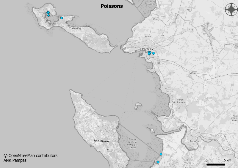
Caractérisation des structures des communautés de poissons selon l'état d'exploitation et les degrés d'immersion des marais de Charente Maritime, entre 2019 et 2021, dans le cadre de l'ANR PAMPAS.
-
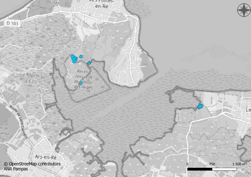
Caractérisation des communautés de poissons dans le Fier d'Ars de l'île de Ré, entre 2019 et 2020, dans le cadre de l'ANR PAMPAS : - poissons transitant dans le chenal qui alimente les vasais de la Réserve naturelle de Lilleau des Niges - dans les vasais de premier rang de la Réserve naturelle de Lilleau des Niges - dans un vasais de premier rang sur le site de l'Ecomusée du marais salant, dans le sud du Fier d'Ars de l'île de Ré,
-

Des prélèvements d'eau ont été réalisés en même temps que le suivi du plancton, à savoir sur les 3 sites d'études de Pampas, entre 2019 et 2022, pour mesurer les sels nutritifs : silicates, nitrates, nitrites, phosphates et ammonium