 Catalogue PIGMA
ADCP
Type of resources
Available actions
Topics
Keywords
Contact for the resource
Provided by
Years
Formats
Representation types
Update frequencies
status
Scale
-
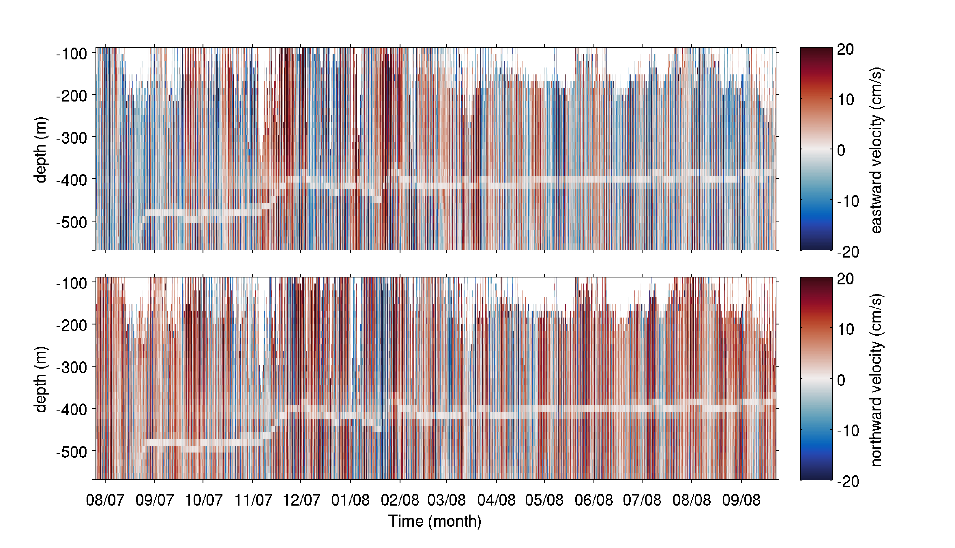
The mooring was deployed on 25 July 2007 from the R/V Haakon Mosby at 80.601°N, 7.119°E (depth of 745 m) in the Yermak Pass over the Yermak Plateau north of Svalbard. It comprised an upward-looking RDI 75kHz Long Ranger Acoustic Doppler Current Profiler (ADCP) at 585 m with 16 m vertical resolution and a 1hour sampling time, and an ocean profiler on a taut cable between 130 and 530 m. The mooring was recovered on 23 September 2008 by the K/V Svalbard. The dataset is composed of the raw data from the ADCP, after declination correction. A white shaded zone is visible in the data between 380 and 500 m depth throughout the time series. It corresponds to the reflection of the acoustic bins on the profiler stuck on the cable.
-

As part of the FEM THYMOTE and PHYSIC projects, which combined measurements and numerical development to obtain high-resolution information on the turbulent flows of tidal stream sites, current measurement campaigns were carried out at the end of 2017 in the Raz Blanchard.
-
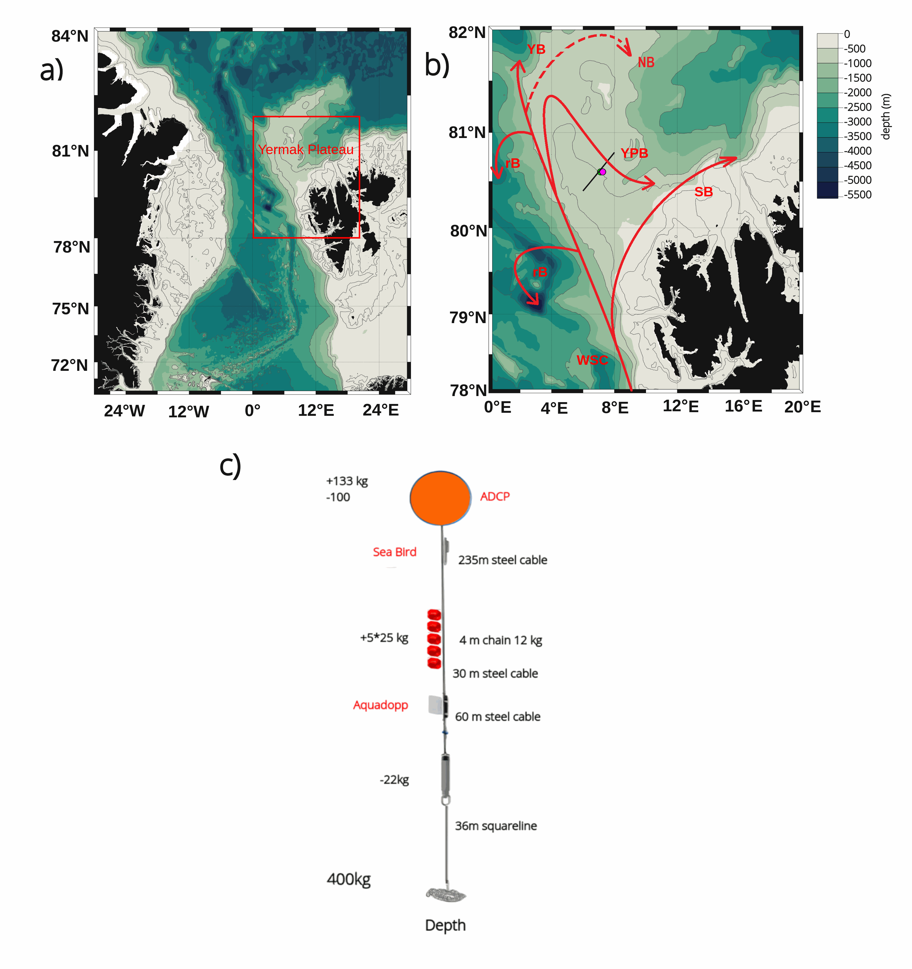
The mooring was deployed on 15 September 2017 from Norwegian Research Vessel Lance at 80.6°N and 7.26°E (depth of 730 m) in the Yermak Pass over the Yermak Plateau north of Svalbard. It comprised 3 instruments: an upward-looking RDI 75kHz, a Long Ranger Acoustic Doppler Current Profiler (ADCP) at 340 m with 16 m vertical resolution (25 bins of 16 m each) and a 2-hour sampling time; a Seabird SBE37 measuring temperature, salinity and pressure at 348 m with 10-minute sampling time; and an Aquadopp current meter at 645 m with a 2-hour sampling time. The mooring was retrieved on the 19 July 2020 by Norwegian Icebreaker K.V. Svalbard. The present dataset features: (i) the ADCP 50-hour smoothed daily velocities, conservative temperature and pressure time series interpolated every 10 meters within the 20-330m layer, (ii) the Aquadopp 50-hour smoothed daily velocities and pressure time series at 645 m; and (iii) the SBE37 50-hour smoothed daily conservative temperature, absolute salinity and pressure time series at 348 m.
-

Current measurements on the water column (11 ADCP) and punctual near the bottom (5 ADV) at Raz Blanchard.
-
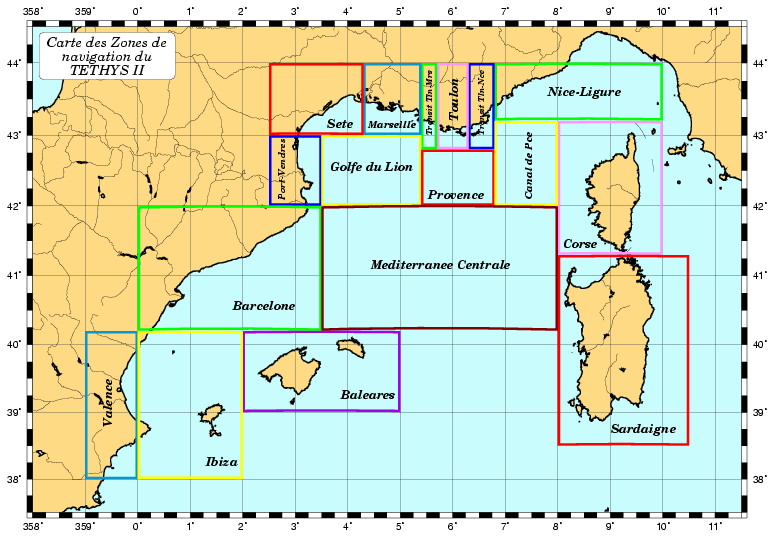
Système Acquisition Validation Exploitation de Données des Navires de l’INSU Méditerranée nord-occidentale et côtes françaises Atlantique/Manche 1996 -
-
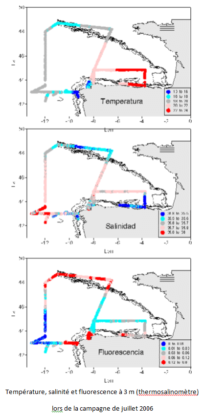
Le but de ce projet est la mise en place d'un réseau d'échantillonnage pour l'étude de la variabilité climatique sur les eaux océaniques autour de la marge ibérique et du golfe de Gascogne, la détermination des flux de chaleur, d'eau douce, de nutriments et de CO2 dans les eaux usées et d'établir des relations avec le NAO. Cela contribue aux programmes internationaux sur la variabilité du climat et au début de l'étude systématique de la région. De plus il facilite l'utilisation d'un modèle numérique de la région. L'objectif principal du projet VACLAN est d'améliorer la capacité d'observation et l'utilisation des nouveaux outils disponibles pour caractériser la variabilité du climat: la télédétection pour l'étude des eaux de surface, les bouées dérivantes pour les eaux supérieures et intermédiaires, les instruments amarrés et les stations hydrographiques profondes pour l'étude de la colonne d'eau. L'utilisation de ces outils couplés à la modélisation numérique permettra de caractériser les flux de CO2 et physico-chimiques dans une zone aussi importante que le courant limite est de l'Atlantique. De plus, une fois validées et contrôlées, les données de ce système seront mises à disposition des communautés scientifique et universitaire et intégrées pour à des modèles numériques de prévision.