 Catalogue PIGMA
Turbidity
Type of resources
Available actions
Topics
Keywords
Contact for the resource
Provided by
Years
Formats
Representation types
Update frequencies
status
Scale
-

Glider data associated with the AMAZOMIX cruise. The Amazon shelf encompasses a variety of physical processes, such as fluvial inputs, coastal currents, mesoscale, filaments, tides, internal waves and upwelling, influencing nutrient concentrations, chlorophyll and suspended matter. They also affect energy, salt and heat balances; parameters that condition physical/biogeochemical interactions and ecosystem functioning, from bacteria to plankton to fish resources. In particular, internal tidal waves are very energetic in this region. They impact biogeochemical cycles via the vertical mixture induced by their dissipation or vertical movements induced by their propagation. They thus allow a significant input of nutriments into the euphotic layer enhancing primary production, as observed on the surface from watercolour data. Internal tidal waves could thus influence the biological pump and the carbon cycle. In addition, overall marine biodiversity of the region, from bacteria to fish is not well described. The connectivity of species in the tropical Atlantic is also still an open question. The Caribbean region is by far more bio-diverse than the Brazilian one. One of the hypotheses is that the Amazon plume, which can extend up to 3,000 km off the mouth, would constitute a barrier for some organisms. The Amazon Shelf is thus an ideal experimental laboratory to study the impact of physical processes on the structure and function of neritic and oceanic marine ecosystems. In this context, the objective of the multidisciplinary AMAZOMIX survey was to study the impact of the Amazon River plume, internal tides and associated turbulent mixing, on marine ecosystem in contrasting regions off the Amazon shelf. For that purpose, the multidisciplinary AMAZOMIX project brings together physicists, biogeochemists, bioopticians and biologists. The sampling strategy consists in the simultaneous acquisition of a comprehensive set of environmental and biological compartments, including micro-organisms (bacteria, phyto and zooplankton) and higher trophic levels (micronekton, demersal and pelagic fish). AMAZOMIX is the first campaign to develop this multi-disciplinary approach off the Amazon shelf. In situ results will be analysed in interaction with digital tools and data, modelling (1/36°, with and without tides, 1/12° coupled) and satellite data analyses. The glider was equipped with: - a Seabird pumped CTD (temperature, pressure, conductivity), - an Aanderaa optode (dissolved oxygen), - and a WetLabs optical puck (chlorophyll-a fluorescence, CDOM, turbidity). Sensors sampled every 5 seconds, corresponding to a vertical resolution of approximately 1 m. Between surfacings, the glider estimated its position using navigation sensors (compass), allowing computation of mean dive-averaged horizontal currents by comparing dead-reckoned positions with GPS fixes. Data were processed using the GEOMAR Matlab Toolbox (Krahmann, 2023), which included correction for thermal lag following Garau et al. (2011). Temperature and salinity were converted to conservative temperature and absolute salinity using the Gibbs Seawater Python library (McDougall & Barker, 2011). Profiles were validated against reference CTD casts at the deployment site.
-

As part of the marine water quality monitoring of the “Pertuis” and the “baie de l’Aiguillon” (France), commissioned by the OFB and carried out by setec énergie environnement, three monitoring stations were installed. Two of them were set up at the mouths of the Charente and Seudre rivers on February 6 and 27, 2019, respectively, while a third was deployed in the Bay of Aiguillon on March 24, 2021. The dataset presented here concerns the station installed in the Bay of Aiguillon. Measurements are organized into .csv files, with one file per year. Data is collected using a WiMO multiparameter probe, which records the following parameters: • Temperature (-2 to 35 °C) • Conductivity (0 to 100 mS/cm) • Pressure (0 to 30 m) • Turbidity (0 to 4000 NTU) • Dissolved Oxygen (0 to 23 mg/L & 0 to 250 %) • Fluorescence (0 to 500 ppb)
-
In the framework of the ANR AMORAD project, the METEOR cruises (Grasso, 2017) aimed at deploying the ‘Gironde Estuary Mouth MEasurement Stations’ (GEMMES) to measure hydrodynamics and sediment dynamics at the mouth of the Gironde Estuary and on the West Gironde Mud Patch (SW France, Bay of Biscay). Measurements were carried out between November 2016 and December 2017: i) from a buoy station around 20-m water depth (GEMMES-20), collecting sub-surface data of temperature, salinity and turbidity; and ii) a benthic station around 40-m water depth (GEMMES-40), collecting data of current velocity and turbidity. Bottom and surface water samples were regularly collected to calibrate turbidity measurements to SPM concentrations.
-

As part of the marine water quality monitoring of the “Pertuis” and the “baie de l’Aiguillon” (France), commissioned by the OFB and carried out by setec énergie environnement, three monitoring stations were installed. Two of them were set up at the mouths of the Charente and Seudre rivers on February 6 and 27, 2019, respectively, while a third was deployed in the Bay of Aiguillon on March 24, 2021. The dataset presented here concerns the station installed in the Charente estuary. Measurements are organized into .csv files, with one file per year. Data is collected using a SAMBAT multiparameter probe, which records the following parameters: - Temperature (-5 to 35 °C) - Conductivity (0 to 10 mS/cm) - Pressure (0 to 10 m) - Turbidity (0 to 300 NTU) - Dissolved Oxygen (0 to 20 mg/L & 0 to 200 %) - Fluorescence (0 to 50 µg/l) - PH (0/14)
-
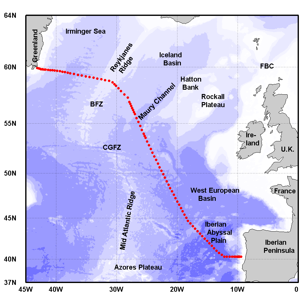
The Greenland-Portugal A25 OVIDE line is carried out biennially since 2002. The section is composed of 98 stations where hydrographic, biogeochemical and current measurements are carried out down to the bottom. OVIDE is a contribution to the international programs Go-Ship, IOCCP, and CLIVAR. This data set contains the final (adjusted) CTDO2 data.
-

The "Acqua Alta" research tower consists of a platform containing an instrument house, supported by a steel pipe structure, similar to that of an oil well derrick. The pipe structure is hammered 22 m into the bottom through each of its four hollow legs. Energy is supplied at 125, 220, 380 VAC (50 Hz –remote activation), along with continuous voltage 12 and 24 VDC. The tower can host two technicians and three scientists for several days and allows specific dedicated campaigns and long-term measurements. A broadband wireless communication system between the tower and the operating Institute allows 10 Mb/s data communication rate and real time data availability. The bridge allows the tower to be part of the Institute LAN so all the scientists on board can access internet and potentially the instruments could be controlled remotely. Measurements routinely acquired with periodic sampling concern biology, chemistry, physical oceanography. Autonomous instrumentations cover atmospheric and hydrological parameters with a series of meteorological stations and oceanographic instruments. A direct view of the sea condition around the tower is available continuously by the three high resolution webcams installed on the roof. Two underwater webcams are installed at -3 and -12 m to observe biological populations and to monitor potentially critical phenomena such as jellyfish swarms and mucilaginous macro aggregates. Given the high level of security and wide desk space, sophisticated instruments can be hosted on board reducing drastically the risk of loss (when not in service the tower is locked and a video surveillance is active). The good level of logistic support allows the setup of in situ experiments.
-
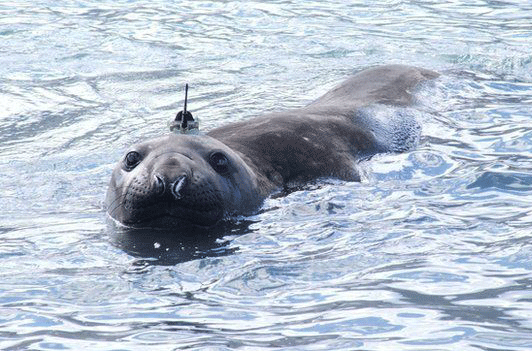
The Southern Ocean plays a fundamental role in regulating the global climate. This ocean also contains a rich and highly productive ecosystem, potentially vulnerable to climate change. Very large national and international efforts are directed towards the modeling of physical oceanographic processes to predict the response of the Southern Ocean to global climate change and the role played by the large-scale ocean climate processes. However, these modeling efforts are greatly limited by the lack of in situ measurements, especially at high latitudes and during winter months. The standard data that are needed to study ocean circulation are vertical profiles of temperature and salinity, from which we can deduce the density of seawater. These are collected with CTD (Conductivity-Temperature-Depth) sensors that are usually deployed on research vessels or, more recently, on autonomous Argo profilers. The use of conventional research vessels to collect these data is very expensive, and does not guarantee access to areas where sea ice is found at the surface of the ocean during the winter months. A recent alternative is the use of autonomous Argo floats. However, this technology is not easy to use in glaciated areas. In this context, the collection of hydrographic profiles from CTDs mounted on marine mammals is very advantageous. The choice of species, gender or age can be done to selectively obtain data in particularly under-sampled areas such as under the sea ice or on continental shelves. Among marine mammals, elephant seals are particularly interesting. Indeed, they have the particularity to continuously dive to great depths (590 ± 200 m, with maxima around 2000 m) for long durations (average length of a dive 25 ± 15 min, maximum 80 min). A Conductivity-Temperature-Depth Satellite Relay Data Logger (CTD-SRDLs) has been developed in the early 2000s to sample temperature and salinity vertical profiles during marine mammal dives (Boehme et al. 2009, Fedak 2013). The CTD-SRDL is attached to the seal on land, then it records hydrographic profiles during its foraging trips, sending the data by satellite ARGOS whenever the seal goes back to the surface.While the principle intent of seal instrumentation was to improve understanding of seal foraging strategies (Biuw et al., 2007), it has also provided as a by-product a viable and cost-effective method of sampling hydrographic properties in many regions of the Southern Ocean (Charrassin et al., 2008; Roquet et al., 2013).
-
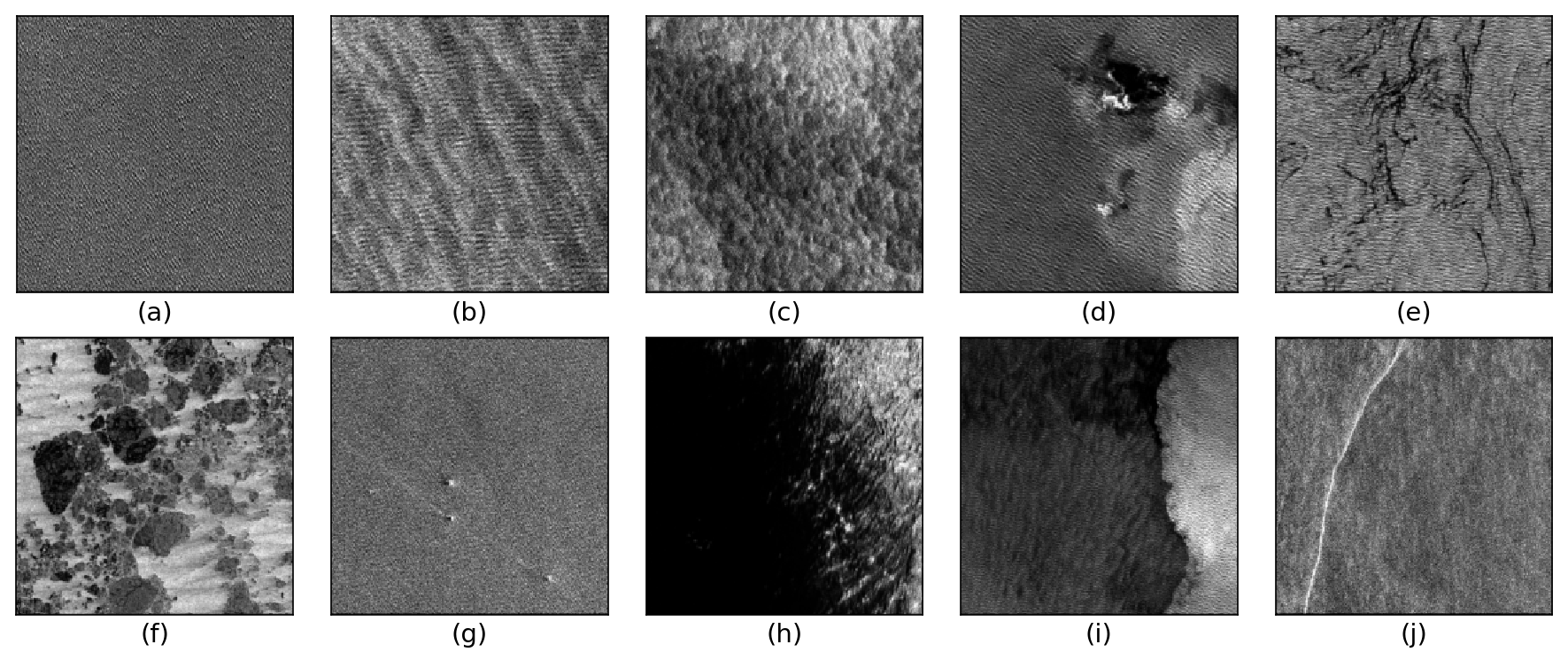
The TenGeoP-SARwv dataset is established based on the acquisitions of Sentinel-1A wave mode (WV) in VV polarization. This dataset consists of more than 37,000 SAR vignettes divided into ten defined geophysical categories, including both oceanic and meteorologic features. These images cover the entire open ocean and are manually selected from Sentinel-1A WV acquisitions in 2016. For each image, only one prevalent geophysical phenomena with its prescribed signature and texture is selected for labeling. The SAR images are processed into a quick-look image provided in the formats of PNG and GeoTIFF as well as the associated labels. They are convenient for both visual inspection and machine-learning-based methods exploitation. The proposed dataset is the first one involving different oceanic or atmospheric phenomena over the open ocean. It seeks to foster the development of strategies or approaches for massive ocean SAR image analysis. A key objective is to allow exploiting the full potential of Sentinel-1 WV SAR acquisitions, which are about 60,000 images per satellite per month and freely available. Such a dataset may be of value to a wide range of users and communities in deep learning, remote sensing, oceanography, and meteorology
-
The Everyone's Gliding Observatories (EGO) initiative is a gathering of several teams of oceanographers, interested in developing the use of gliders for ocean observations. EGO started in Europe with members from France, Germany, Italy, Norway, Spain, and the United Kingdom. The partners of EGO have been funded by both European and national agencies to operate gliders for various purposes and at different sites. Coordinated actions are being set up for these sites in order to demonstrate the capabilities of a fleet of gliders for sampling the ocean, with a given scientific and/or operational objective. Gliders were developed since the 90’s to carry out in-situ observations of the upper 1km of the ocean, filling the gaps left by the existing observing systems. Gliders look like small autonomous robotic underwater vehicles which that uses an engine to change their buoyancy. While gliding from surface to about 1000 meters, gliders provide real-time physical and biogeochemical data along their transit. They observe temperature, salinity, pressure, biogeochemical data or acoustic data.
-
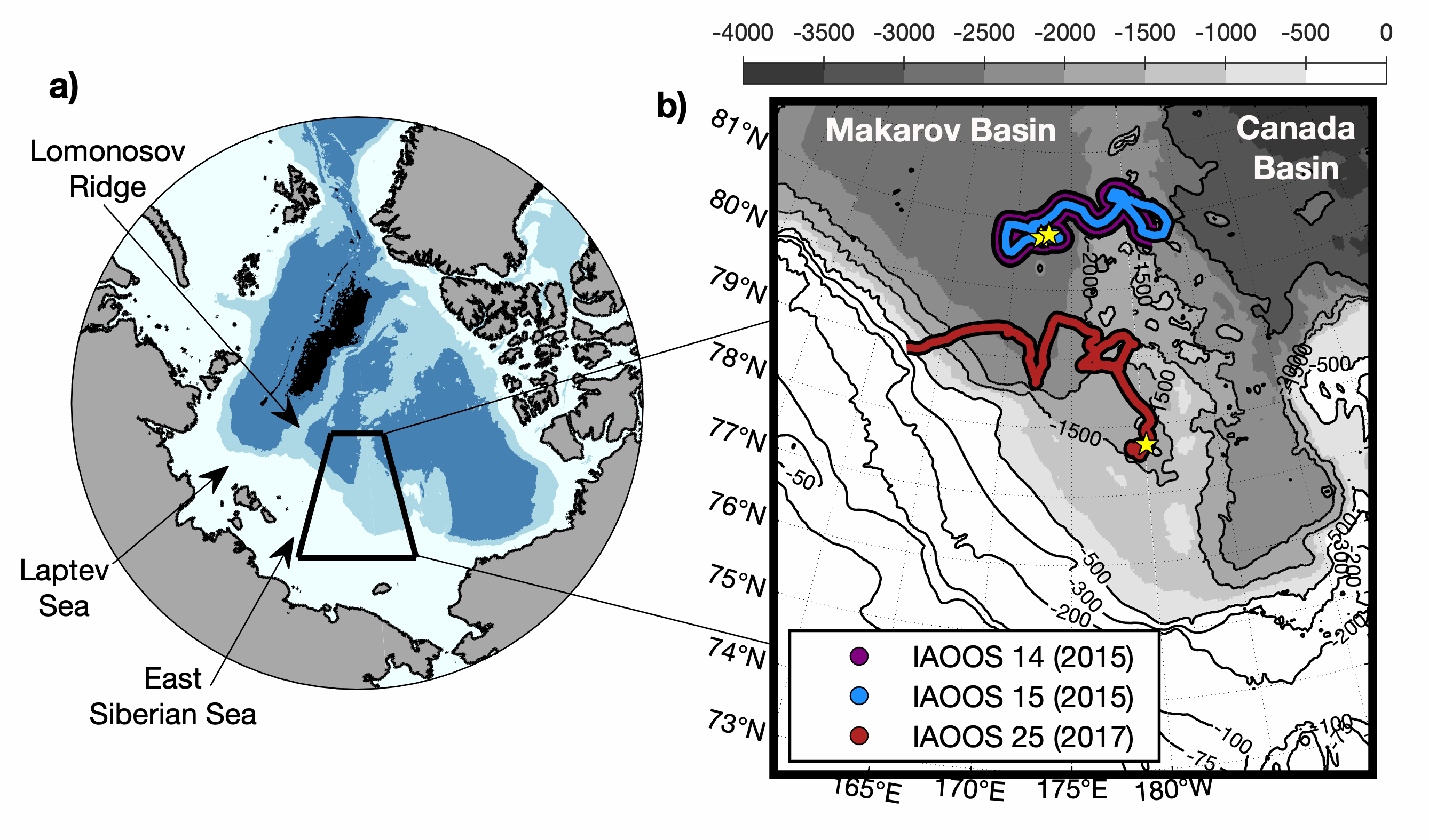
IAOOS14, IAOOS15 and IAOOS25 were deployed from the Korean Icebreaker R/V Araon during cruises in the northern Chukchi Sea. IAOOS14 and IAOOS15 were deployed 300 m apart on the same floe on 12 August 2015 in the Makarov Basin (80.8°N;173°E) and they drifted together remaining always less than 6 km apart. IAOOS25 was deployed on 15 August 2017 south-west Mendeleev Ridge (77.7°N;180°E) and drifted westward to the continental slope of the East Siberian Sea. IAOOS14 and IAOOS25 stopped transmitting on 9 October 2015 and 19 November 2017 respectively, likely due to the loss of their profilers while crossing relatively shallow bathymetry. IAOOS15 dataset ends in 15 October 2015. Ocean profilers were PROVOR SPI (from French manufacturer NKE) equipped with a Seabird SBE41 CTD (Conductivity, Temperature, Depth) and a dissolved oxygen (DO) Aandera 4330 optode. The profilers were set to perform two upward profiles a day from 800 m (IAOOS 14), 300 m (IAOOS 15) and 420 m (IAOOS 25), upward starting at approximately 6 am and 6 pm. The present dataset is composed of CTD-DO data from IAOOS 14 and 15, and CTD data from IAOOS 25 in the Makarov Basin, corrected from salinity errors and interpolated vertically every 0.5 m.