 Catalogue PIGMA
AZTI
Type of resources
Available actions
Topics
Keywords
Contact for the resource
Provided by
Years
Formats
Representation types
Update frequencies
status
-
The challenge attempts to collect data on landings for the North Atlantic sea basin (i.e. north of the equator, excluding Caribe, Baltic, North Sea and Artic) and to compute: mass and number of discards by species and year, including fish, mammals, reptiles and seabirds. Data are presented in an Excel spreadsheet.
-
The challenge attempts to collect bycatch data for the North Atlantic sea basin (i.e. north of the equator, excluding Caribe, Baltic, North Sea and Artic) and to compute: mass and number of discards by species and year, including fish, mammals, reptiles and seabirds. Data are presented in an Excel's spreadsheet.
-
The challenge attempts to collect discards data for the North Atlantic sea basin (i.e. north of the equator, excluding Caribe, Baltic, North Sea and Artic) and to compute: mass and number of discards by species and year, including fish, mammals, reptiles and seabirds. Data are presented in an Excel's spreadsheet.
-
The Alien Species exercise handles the ability to identify alien species in the North Atlantic as follows: • Species name • Taxonomic group (fish, algae, mammals, sponges etc) • Year of first record (e.g: 1240 is the earliest record of introduction) • Pathway/vector of introduction (climate change, ballast water discharge etc) . Status (established, cryptogenic,...) • Geographical area (place names, i.e. ports and bays
-
The challenge attempts to collect data on landings for the North Atlantic sea basin (i.e. north of the equator, excluding Caribe, Baltic, North Sea and Artic) and to compute: mass and number of discards by species and year. In addition, by-catch of fish, mammals, reptiles and seabirds. Data are presented in an Excel spreadsheet.
-
The Alien Species exercise handles the ability to identify alien species in the North Atlantic as follows: • Species name • Taxonomic group (fish, algae, mammals, sponges etc) • Year of first record (e.g: 1240 is the earliest record of introduction) • Pathway/vector of introduction (climate change, ballast water discharge etc) . Status (established, cryptogenic,...) • Geographical area (place names, i.e. ports and bays
-
The challenge attempts to collect discards data for the North Atlantic sea basin (i.e. north of the equator, excluding Caribe, Baltic, North Sea and Artic) and to compute: mass and number of discards by species and year, including fish, mammals, reptiles and seabirds. Data are presented in an Excel's spreadsheet.
-
The challenge attempts to collect bycatch data for the North Atlantic sea basin (i.e. north of the equator, excluding Caribe, Baltic, North Sea and Artic) and to compute: mass and number of discards by species and year, including fish, mammals, reptiles and seabirds. Data are presented in an Excel's spreadsheet.
-
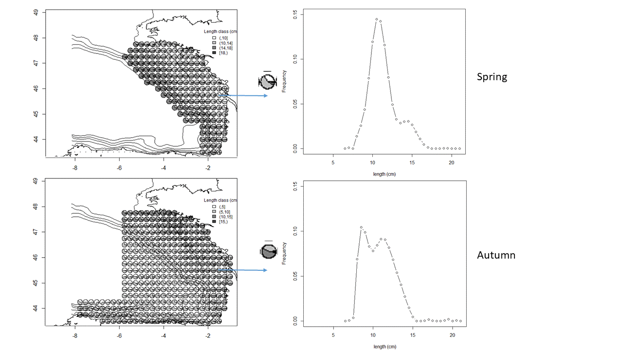
The anchovy (Engraulis encrasicolus) and sardine (Sardina pilchardus) populations in the Bay of Biscay are jointly surveyed each year in May since 2000 and in September since 2003 by means of acoustic surveys. The integrated survey PELGAS (Doray et al., 2018) is run in May by France and covers the French shelf of the Bay of Biscay. Its objectives are to monitor the Bay of Biscay pelagic ecosystem in springtime and assess the biomass of its small pelagic fish species, including sardine and anchovy. Amongst many information on the ecosystem, the survey PELGAS provides knowledge on the adults of anchovy and sardine during their spawning in spring. The survey JUVENA (Boyra et al., 2013) is run in September by Spain. It has a larger spatial coverage than PELGAS, including part of the Spanish coast and open ocean outside the shelf because it targets juvenile anchovy. It also provides knowledge on sardine as well as other pelagic species. Both surveys are coordinated by the ICES Working Group on Acoustic and Egg Surveys for Small Pelagic Fish (WGACEGG), together with other pelagic surveys in ICES areas 7, 8 and 9. Survey protocoles are detailed in Doray et al. (2021). Briefly, fish backscatter data are recorded along the survey transect lines and pelagic trawl hauls are undertaken opportunistically to identify the echotraces to species and collect fish samples for biometric data. The trawl haul catches have provided the anchovy and sardine length data, from which the maps presented here are derived. At each trawl haul, the catch is sorted by species and weighted. A subsample by species is measured to estimate the species’ length distribution. The four maps presented here correspond to the average maps of anchovy and sardine length distributions in May and September, derived from the PELGAS and JUVENA trawl haul data series. The maps were obtained by kriging, following the procedure explained in Petitgas et al. (2011) for mapping functions instead of variables. For each species, the experimental length distribution at each haul was fitted by a linear combination of Legendre polynomials, the coefficients of which were co-kriged. The number of polynomials varied from 15 to 22 depending on the survey and species, with a higher number for sardine and in autumn. The length histogram at each grid node was then deduced from the mapped coefficients. When the length distribution at a given haul was estimated with less than 40 individual fish, the haul was not taken into account for mapping. This threshold defined presence and absence of the species in the haul data sets. The trawl hauls from 2000 to 2019 were pooled for the PELGAS series (1965 stations) and from 2003 to 2020 for JUVENA (852 stations). The mapping was performed on the same grid for both PELGAS and JUVENA and both species, and with similar moving kriging neighbourhoods. The grid has a mesh size of 0.25 x 0.25 decimal degree square. In addition to mapping the length distribution, presence/absence was mapped for each species by ordinary kriging on the same grid and with the same neighbourhoods as previously. The computations were performed in R (version 4.0.5) with the RGeostats package (version 13.0.1) freely available at http://rgeostats.free.fr. The map data files comprise for each species the following information: the geographical coordinates of the grid points, the probability of presence and the probability of each length class of width 0.5 cm ranging from 2.5 to 27 cm.
-
Annual time series of eel recruitement, (2005-2014) • Time series of glass and yellow eel for those rivers used in the annual ICES advice to the EU • Location, data availability and long term annual (LTA) eel recruiment per river mouth