 Catalogue PIGMA
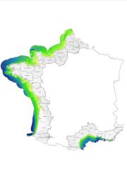
bathymétrie
Type of resources
Available actions
Topics
Keywords
Contact for the resource
Provided by
Years
Formats
Representation types
Update frequencies
status
Service types
Scale
Resolution
-

Bathymetric datasets are an extraction of surveys belonging to the Shom public database. For depth up to 50m, the vertical precision of soundings varies from 30cm to 1m and the horizontal precision varies from 1 to 20m. In deep ocean, the vertical precision is mainly around 1 or 2% of the bottom depth. It is sometimes more, it depends on the technology used. The data are referenced to ZH which is assimilated to LAT. Data are corrected for sound velocity variations.
-
Compilation de plusieurs sources de données : - dalles Histolitt du SHOM - semi de points avec un pas de 500m fourni par l'IFREMER - saisie de lignes bathymétriques sur les cartes SHOM et le GEBCO pour compléter la zone Le semis de points obtenu ne dispose pas d'un pas égal, il est hétérogène. A partir de ces données, une interpolation a été réalisée de manière à obtenir une grille continue de profondeur. Paramètre utilisé : profondeur moyenne h (m) à partir du zéro côte marine
-

Bathymetric datasets are an extraction of surveys belonging to the Shom public database. For depth up to 50m, the vertical precision of soundings varies from 30cm to 1m and the horizontal precision varies from 1 to 20m. In deep ocean, the vertical precision is mainly around 1 or 2% of the bottom depth. It is sometimes more, it depends on the technology used. The data are referenced to ZH which is assimilated to LAT. Data are corrected for sound velocity variations.
-

Compilation de plusieurs sources de données : - dalles Histolitt du SHOM - semi de points avec un pas de 500m fourni par l'IFREMER - saisie de lignes bathymétriques sur les cartes SHOM et le GEBCO pour compléter la zone Le semis de points obtenu ne dispose pas d'un pas égal, il est hétérogène. A partir de ces données, une interpolation a été réalisée de manière à obtenir une grille continue de profondeur. Paramètre utilisé : profondeur moyenne h (m) à partir du zéro côte marine
-

Relevés bathymétriques des Passes du Bassin d'Arcachon
-

Relevés bathymétriques des Passes du Bassin d'Arcachon
-
Serveur wms public de l'Ifremer, Accès aux données du Sismer
-

Bassin versant de la Dordogne : Bathymétrie