 Catalogue PIGMA
500000
Type of resources
Available actions
Topics
Keywords
Contact for the resource
Provided by
Years
Formats
Representation types
Update frequencies
status
Scale
Resolution
-
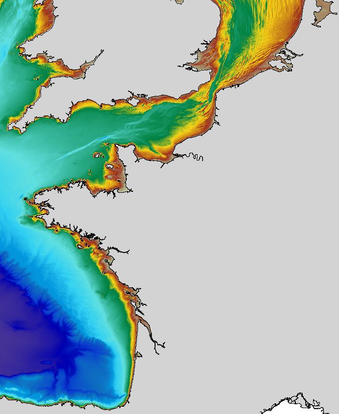
The regional bathymetric Atlantic – Channel – North-Sea DTM has a resolution of 0.001° (~111m). Its geographic coverage includes the Bay of Biscay, the English Channel and a part of the North Sea. The DTM extends from the coast to the continental slope (about of 4800m deep). This DTM is produced in the framework of the HOMONIM project which aims at improving operational forecast capabilities for the national coastal flood warning system. This DTM is offered openly on the Shom diffusion website (http://diffusion.shom.fr/produits/bathymetrie/mnt-facade-atl-homonim.html). http://dx.doi.org/10.17183/MNT_ATL100m_HOMONIM_WGS84
-
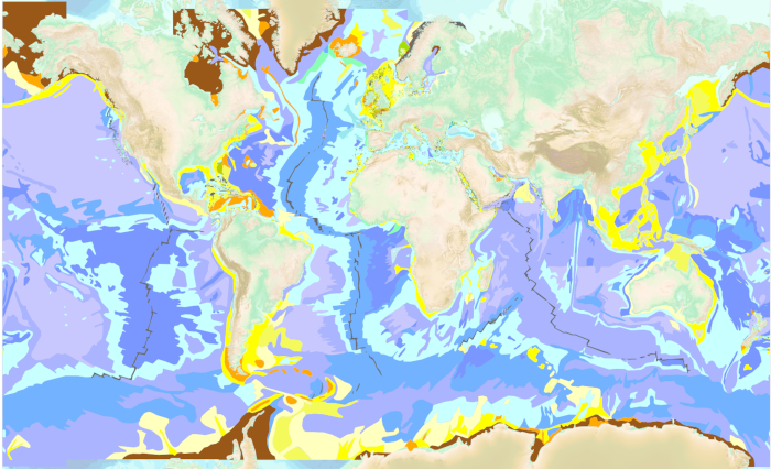
The “World Seabed Sediment Map” product contains geo-referenced digital data, describing the nature of the sediment encountered in different seas and oceans of the world. The objects are all surface areas and the description of an object includes in particular the nature of the sediment including rock-type bottoms.
-

Les périmètres des quartiers prioritaires de la politique de la ville sont fixés par le décret n° 2014-1750 du 30 décembre 2014 pour la métropole et par le décret n° 2014-1751 du 30 décembre 2014 pour les départements et collectivités d’outre-mer, rectifiés par le décret n°2015-1138 du 14 septembre 2015.
-

Sea bed sediment maps for the 4 marine sub-regions prepared as part of the initial evaluation of the MSFD (Marine Strategy Framework Directive).
-
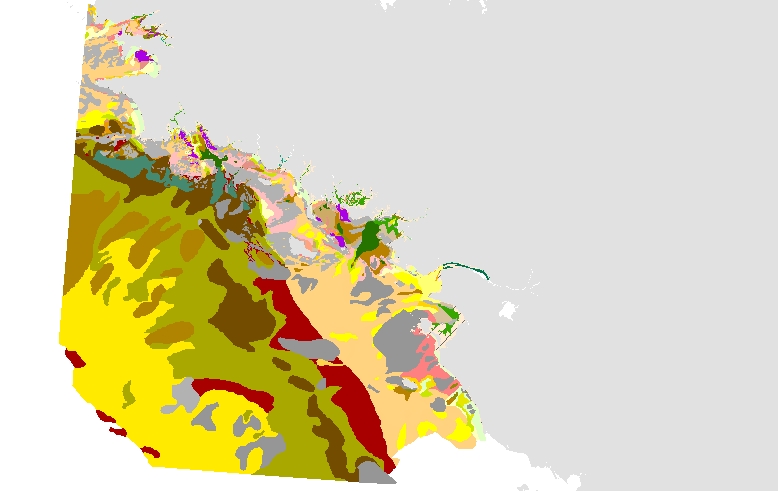
Cette carte est la synthèse des cartes de l'atlas de Claude Chassé et Michel Glémarec de l'Université de Bretagne Occidentale, "Atlas du littoral français, atlas des fonds meubles du plateau continental du Golfe de Gascogne, cartes biosédimentaires", publié en 1976 avec le concours du CNEXO. Cet atlas comprend deux types de cartes : cinq cartes biosédimentaires côtières au 1/100000 et une carte plus générale au 1/500000. Ces cartes ont fait l'objet en 2003 d'une numérisation dans le cadre du Réseau de surveillance de la flore et de la faune benthique marine REBENT. Sous forme numérique, ces cartes ont été regroupées en un seul lot de données.
-

Cartographie de l'Aide du département des Pyrénées Atlantiques à l'installation des Jeunes Agriculteurs (AJA)
-
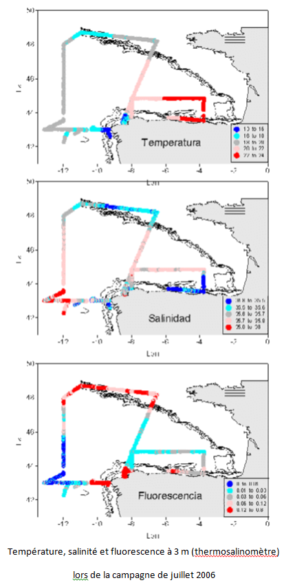
Le but de ce projet est la mise en place d'un réseau d'échantillonnage pour l'étude de la variabilité climatique sur les eaux océaniques autour de la marge ibérique et du golfe de Gascogne, la détermination des flux de chaleur, d'eau douce, de nutriments et de CO2 dans les eaux usées et d'établir des relations avec le NAO. Cela contribue aux programmes internationaux sur la variabilité du climat et au début de l'étude systématique de la région. De plus il facilite l'utilisation d'un modèle numérique de la région. L'objectif principal du projet VACLAN est d'améliorer la capacité d'observation et l'utilisation des nouveaux outils disponibles pour caractériser la variabilité du climat: la télédétection pour l'étude des eaux de surface, les bouées dérivantes pour les eaux supérieures et intermédiaires, les instruments amarrés et les stations hydrographiques profondes pour l'étude de la colonne d'eau. L'utilisation de ces outils couplés à la modélisation numérique permettra de caractériser les flux de CO2 et physico-chimiques dans une zone aussi importante que le courant limite est de l'Atlantique. De plus, une fois validées et contrôlées, les données de ce système seront mises à disposition des communautés scientifique et universitaire et intégrées pour à des modèles numériques de prévision.
-
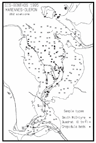
Cartographie des peuplements benthiques de la baie de Marennes-Oléron réalisée en 1995. Ce travail peut-être comparé à celui réalisé par Christian Hily dans la même zone géographique (en partie) lors de sa thèse (1976).
-
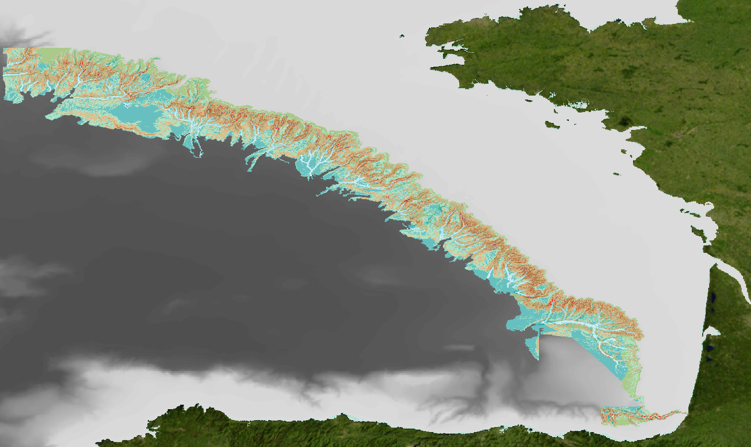
Analyse géomorphologique de la pente continentale du Golfe de Gascogne réalisée sur la base d'un modèle numérique de terrain (MNT) bathymétrique au pas 100m. Ce MNT est une synthèse des données acquises lors des campagnes à la mer ZEE 1, ZEE 2, Sedimanche, Sedifan 1, Sedifan 2, EssNaut 2009, EssReson08, ValidOp, BOBGeo 1, BOBGeo 2, EssInf.
-
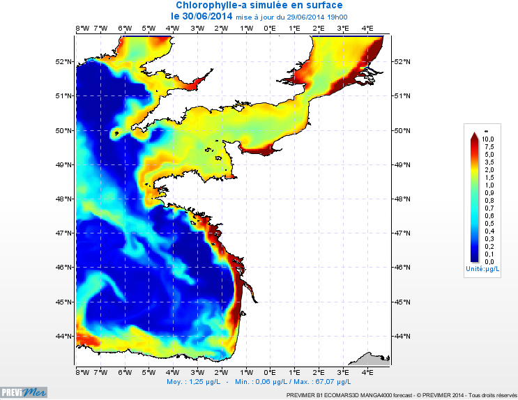
PREVIMER_B1-ECOMARS3D-MANGA4000 est un modèle 3D de résolution spatiale 4km qui fournit les concentrations de nutriments et de plancton toutes les heures sur 30 niveaux (fenêtre de prévision à 4 jours).