 Catalogue PIGMA
200000
Type of resources
Available actions
Topics
Keywords
Contact for the resource
Provided by
Years
Formats
Representation types
Update frequencies
status
Scale
Resolution
-
Cartographie historique des écluses à poissons présentes sur l'île d'Oléron
-
Ce jeu de données permet d'accéder aux 9 millions d'entreprises et 10 millions d'établissements actifs du répertoire Sirene de l'Insee qui enregistre quotidiennement leur état civil : quelle que soit leur forme juridique ; quel que soit leur secteur d'activité (industriels, commerçants, artisans, professions libérales, agriculteurs, collectivités territoriales, banques, assurances, associations...) ; situés en France métropolitaine, ainsi qu'en Guadeloupe, Martinique, Guyane, La Réunion, Mayotte, Saint-Barthélemy, Saint-Martin et Saint-Pierre-et-Miquelon. Les organismes publics ou privés et les entreprises étrangères qui ont une représentation ou une activité en France y sont également répertoriés. Le répertoire Sirene est ainsi la principale source exhaustive sur l'ensemble des entreprises et des établissements actifs. --- Etat de disponibilité de la donnée: - Data.gouv : répertoire SIREN téléchargeable au format csv et mise à jour quotidienne. - PIGMA : donnée de 2009 au format shape. - Géocatalogue : métadonnée au format csv du 01/01/2016.
-
Le Référentiel de l’organisation administrative de l’Etat, nouvelle appellation de la base, comprend toutes les institutions régies par la Constitution de la Ve République et les administrations qui en dépendent, soit environ 6000 organismes. Le périmètre couvre les services centraux de l’Etat, jusqu’au niveau des bureaux. --- Etat de disponibilité de la donnée : - Data.gouv : donnée téléchargeable au format rdf et mise à jour hebdomadaire. Aucun millésime antérieur à 2017.
-
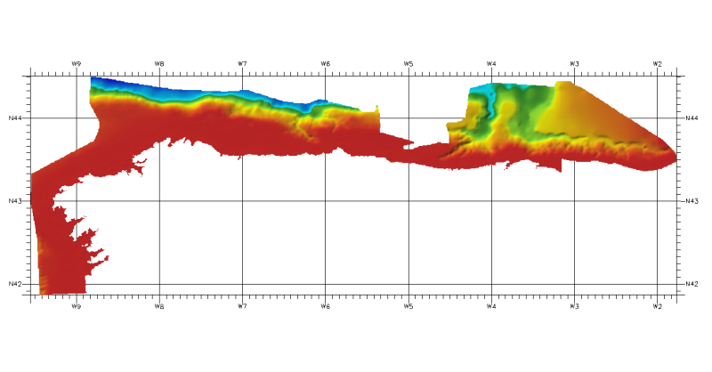
DTM of coast of Biscay and Guipuzcoa , approximately 250 m resolution. This DTM includes the whole area from coast line to deepest level (144,058 m)
-
Limite de circonscription du Grand Port Maritime de Bordeaux. Décret N° 2001-669 du 20 juillet 2001 portant modification des limites de la circonscription du Port Autonome de Bordeaux.
-
A partir des données Corine Land Cover, la carte présente l'évolution de l'urbanisation entre 1990 et 2006. L'objectif est de visualiser et de calculer la part de l'urbain situé près des grands axes routiers traversant le Parc Naturel Régional des Landes de Gascogne. Zone d'étude : L'urbanisation au nord du PNR représente un fort enjeu car la zone étudiée est située entre le Bassin d'Arcachon et l'agglomération bordelaise, et est bien desservie par le réseau viaire. La zone d'étude correspond aux communes du nord du PNR desservies par les routes primaires (définis par la BD TOPO 2009 de l'IGN) Données utilisées : -Corine Land Cover 2006 -Corine Land Cover Evolution 1990-2000 -Corine Land Cover Evolution 2000-2006 -BD TOPO 2009 Routes primaires de l'IGN -GEOFLA Communes de l'IGN -Limites administratives du PNR des Landes de Gascogne Traitement des données : Permet d'identifier : - la part d'urbain situé près des grands axes routiers desservant le PNR des Landes de Gascogne par rapport au bâti de la zone d'étude - la part d'urbain situé à proximité des grands axes routiers desservant le PNR des Landes de Gascogne - l'évolution du bâti depuis 2006 par rapport à 1990 sur la zone d'étude - la part du nouveau bati (entre 1990 et 2006) implantée en bordure des grands axes routiers
-

Effets de la pollution atmosphérique industrielle sur la population de la presqu'île d'Ambès (ERS)
-
Dans un contexte marqué par de fortes mutations de l’environnement économique et social, le ROME (Répertoire Opérationnel des Métiers et des Emplois) est un outil au service de la mobilité professionnelle et du rapprochement entre offres et candidats. En décembre 2016, les référentiels de compétences du ROME évoluent afin d'améliorer la transversalité lors du rapprochement entre l'offre et la demande. Cette évolution consiste à : • réorganiser les compétences en savoir-faire et savoirs • reformuler les libellés en les simplifiant et les décontextualisant. --- Etat de la disponibilité de la donnée : - Data.gouv : donnée téléchargeable au format excel et mise à jour trimestrielle.
-

Plan Particulier de Mise en Sureté des élèves des écoles et collèges de la presqu'ile d"Ambès et travaux associés
-
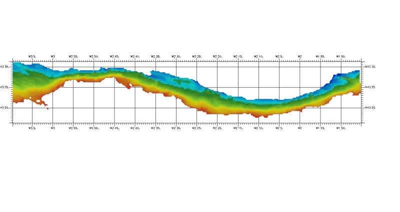
DTM of continental margin of Cantabric Sea, approximately 200 m resolution. This DTM includes the whole area from coast line to deepest level (5216,74 m).