 Catalogue PIGMA
quarterly
Type of resources
Available actions
Topics
Keywords
Contact for the resource
Provided by
Years
Formats
Representation types
Update frequencies
status
Scale
Resolution
-
Dans un contexte marqué par de fortes mutations de l’environnement économique et social, le ROME (Répertoire Opérationnel des Métiers et des Emplois) est un outil au service de la mobilité professionnelle et du rapprochement entre offres et candidats. En décembre 2016, les référentiels de compétences du ROME évoluent afin d'améliorer la transversalité lors du rapprochement entre l'offre et la demande. Cette évolution consiste à : • réorganiser les compétences en savoir-faire et savoirs • reformuler les libellés en les simplifiant et les décontextualisant. --- Etat de la disponibilité de la donnée : - Data.gouv : donnée téléchargeable au format excel et mise à jour trimestrielle.
-

'''DEFINITION''' The sea level ocean monitoring indicator has been presented in the Copernicus Ocean State Report #8. The ocean monitoring indicator on mean sea level is derived from the DUACS delayed-time (DT-2024 version, “my” (multi-year) dataset used when available) sea level anomaly maps from satellite altimetry based on a stable number of altimeters (two) in the satellite constellation. These products are distributed by the Copernicus Climate Change Service and by the Copernicus Marine Service (SEALEVEL_GLO_PHY_CLIMATE_L4_MY_008_057). The time series of area averaged anomalies correspond to the area average of the maps in the Northeast Atlantic Ocean and adjacent seas Sea weighted by the cosine of the latitude (to consider the changing area in each grid with latitude) and by the proportion of ocean in each grid (to consider the coastal areas). The time series are corrected from regional mean GIA correction (weighted GIA mean of a 27 ensemble model following Spada et Melini, 2019). The time series are adjusted for seasonal annual and semi-annual signals and low-pass filtered at 6 months. Then, the trends/accelerations are estimated on the time series using ordinary least square fit. Uncertainty is provided in a 90% confidence interval. It is calculated as the weighted mean uncertainties in the region from Prandi et al., 2021. This estimate only considers errors related to the altimeter observation system (i.e., orbit determination errors, geophysical correction errors and inter-mission bias correction errors). The presence of the interannual signal can strongly influence the trend estimation depending on the period considered (Wang et al., 2021; Cazenave et al., 2014). The uncertainty linked to this effect is not considered. ""CONTEXT "" Change in mean sea level is an essential indicator of our evolving climate, as it reflects both the thermal expansion of the ocean in response to its warming and the increase in ocean mass due to the melting of ice sheets and glaciers (WCRP Global Sea Level Budget Group, 2018). At regional scale, sea level does not change homogenously. It is influenced by various other processes, with different spatial and temporal scales, such as local ocean dynamic, atmospheric forcing, Earth gravity and vertical land motion changes (IPCC WGI, 2021). The adverse effects of floods, storms and tropical cyclones, and the resulting losses and damage, have increased as a result of rising sea levels, increasing people and infrastructure vulnerability and food security risks, particularly in low-lying areas and island states (IPCC, 2022a). Adaptation and mitigation measures such as the restoration of mangroves and coastal wetlands, reduce the risks from sea level rise (IPCC, 2022b). In this region, sea level variations are influenced by the North Atlantic Oscillation (NAO) (e.g. Delworth and Zeng, 2016) and the Atlantic Meridional Overturning Circulation (AMOC) (e.g. Chafik et al., 2019). Hermans et al., 2020 also reported the dominant influence of wind on interannual sea level variability in a large part of this area. This region encompasses the Mediterranean, IBI, North-West shelf, Black Sea and Baltic regions with different sea level dynamics detailed in the regional indicators. ""KEY FINDINGS"" Over the [1999/02/20 to 2025/10/18] period, the area-averaged sea level in the Northeast Atlantic Ocean and adjacent seas area rises at a rate of 4.0 ± 0.8 mm/yr with an acceleration of 0.23 ± 0.06 mm/yr². This trend estimation is based on the altimeter measurements corrected from regional GIA correction (Spada et Melini, 2019) to consider the ongoing movement of land. The TOPEX-A is no longer included in the computation of regional mean sea level parameters (trend and acceleration) with version 2024 products due to potential drifts, and ongoing work aims to develop a new empirical correction. Calculation begins in February 1999 (the start of the TOPEX-B period). '''DOI (product):''' https://doi.org/10.48670/mds-00335
-
-
Le plan cadastral est le découpage du territoire français en unités de surfaces permettant le calcul de certains impôts (notamment la taxe foncière, la taxe d'habitation et la cotisation foncière des entreprises). La consultation du cadastre peut se faire en ligne sur https://cadastre.gouv.fr. Chaque commune est subdivisée en sections, elles-mêmes subdivisées en feuilles (ou planches). Une feuille cadastrale comporte des parcelles, qui peuvent supporter des bâtiments, ainsi que de nombreux autres objets d'habillage ou de gestion. --- Etat de la disponibilité de la donnée : - Data.gouv : donnée téléchargeable au format EDIGEO L93 (formats EDIGEO Zone CC et DXF à venir)et mise à jour trimestriellement.Elle est anonymisée.
-

'''Short description:''' For the Global Ocean- In-situ observation yearly delivery in delayed mode. The In Situ delayed mode product designed for reanalysis purposes integrates the best available version of in situ data for temperature and salinity measurements. These data are collected from main global networks (Argo, GOSUD, OceanSITES, World Ocean Database) completed by European data provided by EUROGOOS regional systems and national system by the regional INS TAC components. It is updated on a yearly basis. This version is a merged product between the previous verion of CORA and EN4 distributed by the Met Office for the period 1950-1990. '''DOI (product) :''' https://doi.org/10.17882/46219
-
Ce jeu de données représente par un ponctuel la position des stationnements vélo sécurisés présents sur le territoire de Bordeaux Métropole, en gestion par les Transports Bordeaux Métropole. Il fournit des données sur leurs caractéristiques administratives, techniques et tarifaires (gestionnaire, nombre et types de places, tarifs types).
-

Récoltes en Gironde : Le Porge, Lacanau, Lège. Secteurs à ramassages manuels, mécaniques, mixtes des laisses de mer. Récoltes dans les Landes : Mimizan, Tarnos. Secteurs à ramassages manuels et mécaniques des laisses de mer. Comparaison des effectifs identifiés.
-
Objets surfaciques du Plan cadastral de Bordeaux Métropole représentant un territoire communal contenant un nombre entier de sections cadastrales. Son emprise est constituée à partir de l'union des sections qui la composent. Le cadastre français est divisé en communes, chaque commune étant elle-même subdivisée en sections, et chaque section en feuilles. Sur chaque feuille figure une ou plusieurs parcelles, unité de la propriété foncière.
-
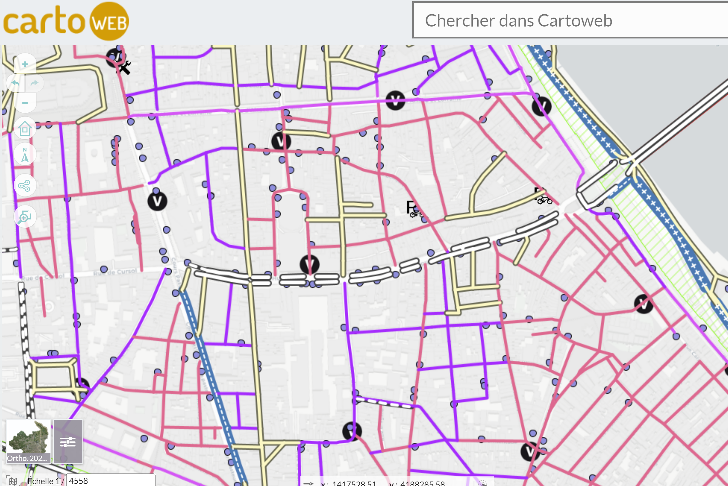
Ce jeu de données signale sous forme de ponctuels les appareils de mesure disséminés sur le réseau d'eau potable et destinés à mesurer des informations relatives à sa pression, son débit, sa qualité ou son volume.
-
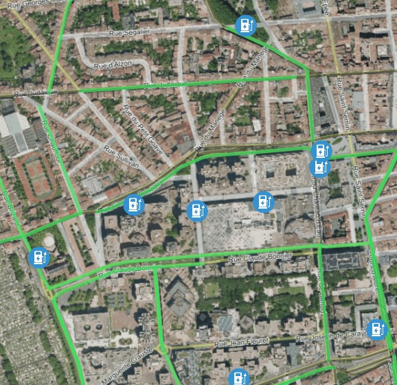
Ce jeu de données représente par un ponctuel la localisation des points de charge (PDC) des stations de recharge pour véhicules électriques sur le réseau de voirie de Bordeaux Métropole et dans les parkings clos accessibles au public. Il informe des possibilités de charge ouvertes au public. Cette donnée est en lien avec la table ST_IRVE_STA_P qui agrège par un ponctuel représentant la station les différents points de charge (Une station se composant d'un à plusieurs points de charge).