 Catalogue PIGMA
Contaminants
Type of resources
Available actions
Topics
Keywords
Contact for the resource
Provided by
Years
Formats
Representation types
Update frequencies
status
Scale
-
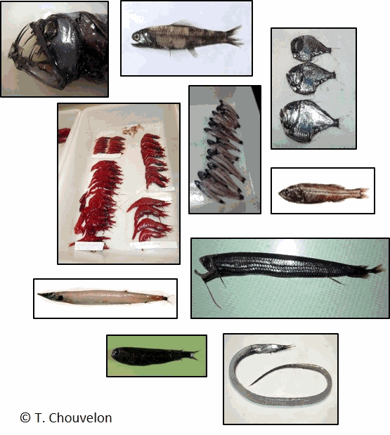
The data file present detailed individual congener/compound concentrations for a large variety of hydrophobic organic contaminants including polychlorinated biphenyls (PCBs), organochlorine pesticides (OCPs), legacy and alternative brominated flame retardants (BFRs) and per- and polyfluoroalkyl substances (PFASs) in meso- and bathypelagic organisms collected in the Bay of Biscay, northeast Atlantic, in October 2017. The studied species include 3 crustacean species (Pasiphaea sivado, Sergia robusta, Ephyrina figueirai) and 11 fish species (Xenodermichthys copei, Searsia koefoedi, Myctophum punctatum, Notoscopelus kroeyeri, Lampanyctus crocodilus, Argyropelecus olfersii, Arctozenus risso, Stomias boa, Serrivomer beanii, Chauliodus sloani, Aphanopus carbo). The organisms were collected at night during one single trawling using a 25 m vertical opening pelagic trawl in the deep scattering layer (ca 800 m depth in the water column; 1330 m bottom floor). This dataset was used in the article entitled "A large diversity of organohalogen contaminants reach the meso- and bathypelagic organisms in the Bay of Biscay (northeast Atlantic)" published in Marine Pollution Bulletin.
-
210Pb, 226Ra and 137Cs were measured by non-destructive gamma spectrometry on marine sediment cores, collected during RIKEAU 2002 cruise on board r/v Thalia, on the shelf of the Bay of Biscay
-
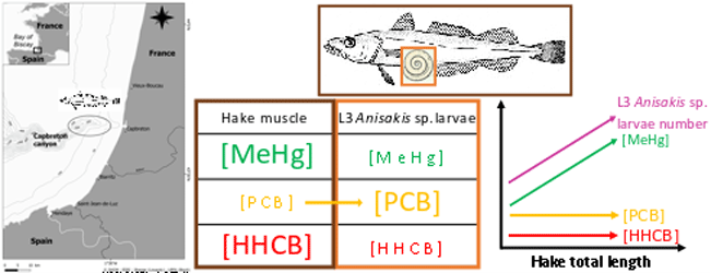
This dataset gathers isotopic ratios (carbon and nitrogen) and concentrations of both priority (mercury species and polychlorinated biphenyls congeners) and emerging (musks and sunscreens) micropollutants measured in a host-parasite couple (hake Merluccius merluccius muscle and in its parasite Anisakis sp) from the south of Bay of Biscay in 2018. In addition, the hake infection degree measured as the number of Anisakis sp. larvae was added for each hake collected.
-
Rocch, the french "mussel watch", provides chemical data for marine quality management. Once a year, trace metals, organic compounds (chlorinated, PAH, brominated flame retardants, perfluorinated compounds, organotins ...) are analysed in molluscs tissues to check chemical quality according to European Framework Directives and to Regional Seas Convention (OSPAR).
-
Good Environmental Status assessment (GES) for descriptor 8 (contaminants, D8) of the Marine Strategy Framework Directive (MSFD) is reached when concentrations of contaminants are at levels not giving rise to pollution effects. It is described by 4 criteria among which the first one focus on the concentration of the contaminants in the environment (criteria 1 of the D8, D8C1). The environmental status for D8 in France includes assessment of contaminant concentrations in sediment, bivalves, fish, birds, mammals to cover the French marine area the continental shelf from the coast line). The 8 tables below present the assessment of the chemical contamination in sediment and bivalves on the coastal area of the 4 French marine subregions for D8 as part of the 2024 GES assessment. These tables report the status and temporal trends of each station x matrice x substance triplet in each of the 4 French marine subregions. Explanation on how to read the cells is given in the “read file”. The environmental assessment for D8 in France can be found in Mauffret al., 2023 (DOI:10.13155/97214). It includes 17 national indicator assessments, 4 OSPAR indicators and integrated assessment in selected assessment units at the level of the criteria 1 and 2.
-

ROCCH, the French Chemical Contaminant Monitoring Network, regularly provides data for assessing the chemical quality of French coastal waters. Concentrations of trace metals and organic compounds are measured in integrative matrices (bivalves and sediments). Surface sediment samples are collected from 200 to 250 monitoring stations in the English Channel, the Bay of Biscay and Mediterranean lagoons every six years. Results concerning approximately 140 historical and emerging chemical substances (metals, PAHs, PCBs, PBDEs, PFAS …) are submitted to international databases of the Regional Sea Convention (OSPAR for the North East Atlantic and the Barcelona Convention for the Mediterranean) and disseminated to public stakeholders. During the ROCCHSED campaign in spring 2022, three sediment cores, each forty to fifty centimetres long, were collected from three different sites in the Bay of Biscay. Horizons of one to two centimetres in length were dated, sieved and freeze-dried for chemical analysis. The concentrations of metals, PAHs and PCBs were determined in horizons aged from over 150 years to the present in order to define the reference concentration of natural levels and describe the temporal profile of contamination.
-
ROCCH, the French Chemical Contaminant Monitoring Network, regularly provides a new official dataset for assessing the chemical quality status of French coastal waters. Concentrations of trace metal elements and organic compounds were measured in samples of marine surface sediments collected in the English Channel and Bay of Biscay, during 3 campaigns over a period of 6 years. Samples of fine sediment material, from 200 to 250 monitoring stations, were freeze-dried and sieved prior to analysis. The Results were submitted to the international database of ICES (for the OSPAR Convention).
-

Dataset summaryPlankton and detritus are essential components of the Earth’s oceans influencing biogeochemical cycles and carbon sequestration. Climate change impacts their composition and marine ecosystems as a whole. To improve our understanding of these changes, standardized observation methods and integrated global datasets are needed to enhance the accuracy of ecological and climate models. Here, we present a global dataset for plankton and detritus obtained by two versions of the Underwater Vision Profiler 5 (UVP5). This release contains the images classified in 33 homogenized categories, as well as the metadata associated with them, reaching 3,114 profiles and ca. 8 million objects acquired between 2008-2018 at global scale. The geographical distribution of the dataset is unbalanced, with the Equatorial region (30° S - 30° N) being the most represented, followed by the high latitudes in the northern hemisphere and lastly the high latitudes in the Southern Hemisphere. Detritus is the most abundant category in terms of concentration (90%) and biovolume (95%), although its classification in different morphotypes is still not well established. Copepoda was the most abundant taxa within the plankton, with Trichodesmium colonies being the second most abundant. The two versions of UVP5 (SD and HD) have different imagers, resulting in a different effective size range to analyse plankton and detritus from the images (HD objects >600 µm, SD objects >1 mm) and morphological properties (grey levels, etc.) presenting similar patterns, although the ranges may differ. A large number of images of plankton and detritus will be collected in the future by the UVP5, and the public availability of this dataset will help it being utilized as a training set for machine learning and being improved by the scientific community. This will reduce uncertainty by classifying previously unclassified objects and expand the classification categories, ultimately enhancing biodiversity quantification.Data tablesThe data set is organised according to:- samples : Underwater Vision Profiler 5 profiles, taken at a given point in space and time. - objects : individual UVP images, taken at a given depth along the each profile, on which various morphological features were measured and that where then classified taxonomically in EcoTaxa.samples and objects have unique identifiers. The sample_id is used to link the different tables of the data set together. All files are Tab separated values, UTF8 encoded, gzip compressed.samples.tsv.gz - sample_id unique sample identifier - sample_name original sample identifier - project EcoPart project title - lat, lon location [decimal degrees] - datetime date and time of start of profile [ISO 8601: YYYY-MM-DDTHH:MM:SSZ] - pixel_size size of one pixel [mm] - uvp_model version of the UVP: SD: standard definition, ZD: zoomed, HD: high definitionsamples_volume.tsv.gzAlong a profile, the UVP takes many images, each of a fixed volume. The profiles are cut into 5 m depth bins in which the number of images taken is recorded and hence the imaged volume is known. This is necessary to compute concentrations. - sample_id unique sample identifier - mid_depth_bin middle of the depth bin (2.5 = from 0 to 5 m depth) [m] - water_volume_imaged volume imaged = number of full images × unit volume [L]objects.tsv.gz - object_id unique object identifier - object_name original object identifier - sample_id unique sample identifier - depth depth at which the image was taken [m] - mid_depth_bin corresponding depth bin [m]; to match with samples_volumes - taxon original taxonomic name as in EcoTaxa; is not consistent across projects - lineage taxonomic lineage corresponding to that name - classif_author unique, anonymised identifier of the user who performed this classification - classif_datetime date and time at which the classification was - group broader taxonomic name, for which the identification is consistent over the whole dataset - group_lineage taxonomic lineage corresponding to this broader group - area_mm2 measurements on the object, in real worl units (i.e. comparable across the whole dataset) … - major_mm - area measurements on the objet, in [pixels] and therefore not directly comparable among the different UVP models and units - mean … - skeleton_area properties_per_bin.tsv.gzThe information above allows to compute concentrations, biovolumes, and average grey level within a given depth bin. The code to do so is in `summarise_objects_properties.R`. - sample_id unique sample identifier - depth_range range of depth over which the concentration/biovolume are computed: (start,end], in [m] where `(` means not including, `]` means including - group broad taxonomic group - concentration concentration [ind/L] - biovolume biovolume [mm3/L] - avg_grey average grey level of particles [no unit; 0 is black, 255 is white]ODV_biovolumes.txt, ODV_concentrations.txt, ODV_grey_levels.txtThis is the same information as above, formatted in a way that Ocean Data View https://odv.awi.de can read. In ODV, go to Import > ODV Spreadsheet and accept all default choices.ImagesThe images are provided in a separate, much larger, zip file. They are stored with the format `sample_id/object_id.jpg`, where `sample_id` and `object_id` are the integer identifiers used in the data tables above.
-
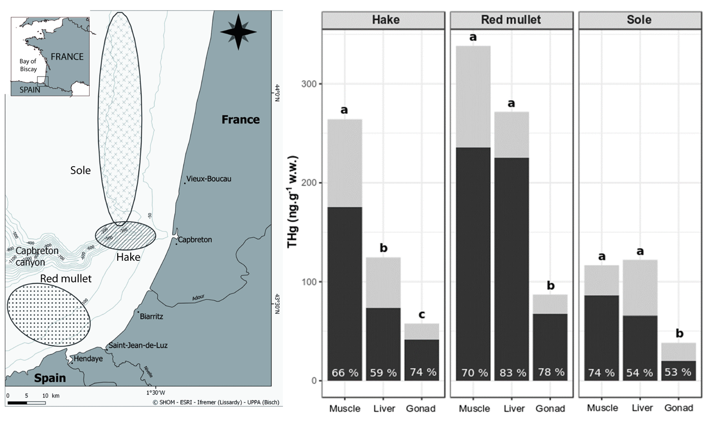
This dataset gather isotopic ratios (carbon and nitrogen) and concentrations of mercury species (methyl and inorganic mercury) measured in several tissues (muscle, liver and gonad) for three commonly consumed fish species from the south Bay of Biscay (France) in 2017 and 2018.
-

Il s'agit des HAP (Hydrocarbures Aromatiques Polycycliques) relevés au niveau de Donges. On en a relevé 14.