 Catalogue PIGMA
/Observational data/satellite
Type of resources
Available actions
Topics
Keywords
Contact for the resource
Provided by
Years
Formats
Representation types
Update frequencies
status
Scale
Resolution
-

These gridded products are produced from the following upstream data: - for satellites SARAL/AltiKa, Cryosat-2, HaiYang-2B, Jason-3, Copernicus Sentinel-3A/B, Sentinel-6 MF, SWOT Nadir => NRT (Near-Real-Time) Nadir along-track (or Level-3) SEA LEVEL products (DOI: https://doi.org/10.48670/moi-00147) delivered by the Copernicus Marine Service (http://marine.copernicus.eu/ ). The gridded product is based on near-real-time (NRT) Level-3 Nadir datasets for the period from July 7, 2025, to December 31, 2025. => MY (Multi-Year) Nadir along-track (or Level-3) SEA LEVEL products (DOI: https://doi.org/10.48670/moi-00146 ) delivered by the Copernicus Marine Service (CMEMS, http://marine.copernicus.eu/ ). The gridded product is based on MY Level-3 Nadir datasets for the period from March 28, 2023, to July 6, 2025. - for SWOT KaRIn : the L3_LR_SSH Expert v3.0 product distributed by AVISO (DOI: https://doi.org/10.24400/527896/A01-2023.018) from March 28, 2023 to December 31, 2025. One mapping algorithm is proposed: the MIOST approach which provides which provides global Sea Surface Height (SSH) solutions. The MIOST method is capable of accounting for various modes of ocean surface topography variability (e.g., geostrophic, barotropic, equatorial wave dynamics) by constructing multiple independent components within a predefined covariance model.
-
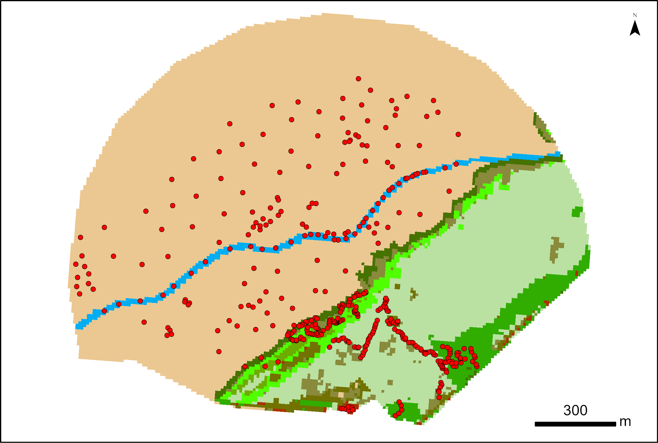
387 points were surveyed with a SP80 DGPS by Maxime Paschal as part of the La Rochelle Zero Carbon Territory (LRTZC) project on 26/05/23. At each point, the type of vegetation was specified.
-
Archive de toutes les données de température de surface (SST) satellite produites dans le cadre du projet international GHRSST. Ifremer est un GDAC pour ces données, miroir du GDAC NASA/JPL. Ces données sont utilisées pour la génération de produits multi-capteurs (CMEMS, Medspiration) mais également dans le cadre d'un grand nombre d'études ou projets nécessitant l'utilisation de mesures de SST. L'archive regroupe plusieurs jeux de données provenant de différents satellite ainsi que des données in situ de référence pour leur validation. Elle est mise à jour en temps quasi-réel depuis 10 ans, avec service de diffusion opérationnelle associé (FTP et HTTP). Une fiche sextant (issue du catalogue CERSAT) sera fournie pour chaque dataset dans cette archive.
-

This daily High-Resolution (HR) Level 3 gridded wind product is derived from Copernicus Sentinel-1 SAR (Synthetic Aperture Radar) observations, over the North Western Atlantic ("ATL" area). It is based on the European Space Agency (ESA) Level-2 OCN products at the highest available resolution. Although L2-OCN products already contain wind vectors, those are calculated using the CMOD5.n Geophysical Model Function (GMF) applied to the co-polarized (co-pol) VV channel (emitting in Vertical polarization and receiving in Vertical polarization). This VV GMF was mapped from scatterometer sensors (Hersbach et al., 2007) which are only able to use co-pol measurements. However, these co-pol GMF are known to lose sensitivity for wind above 20 m/s. Therefore, wind based on such GMF alone, are known to under-estimate wind speed (Polverari et al., 2022). For the L3 products winds based on SAR, we take advantage of the available cross-polarized (cross-pol) VH channel (emitting in Vertical polarization and receiving in Horizontal polarization) for which GMF were specifically derived based on C-Band SAR (Mouche et al., 2017, Mouche et al., 2019). Winds estimated from the combination of both the co-pol and cross-pol channels are referred to as dual-polarization (or dual-pol) winds. As shown in Mouche et al. (2019), taking advantage of the dual polarization strongly improves the wind estimation for high wind conditions thanks to the much greater VH channel sensitivity compared to VV. These new wind estimations are then gridded with a 0.012 degree resolution (between 0.5 and 1.2 km in zonal direction depending on the latitude and 1.3 km in meridional direction) using a cylindrical equidistant projection, independently for ascending and descending satellite passes and for each satellite (so 4 wind fields are available per day for two satellites). This dataset is generated over all Sentinel-1 mission time series starting from March 2018 and updated in delayed mode with a 4-months delay. It is also produced for 4 other different European areas. This dataset is produced and disseminated in the frame of Copernicus Marine Service.
-

This Level 2 product provides marine reflectances from the VENµS mission, processed with the Polymer algorithm, on a subset of sites with coastal or inland areas. VENµS (Vegetation and Environment monitoring on a New Micro-Satellite) is a Franco-Israeli satellite launched in 2017, dedicated to the fine and regular monitoring of terrestrial vegetation, in particular cultivated areas, forests, protected natural areas, etc. The images acquired in 12 spectral bands by a camera provided by CNES, on a selection of about one hundred scientific sites spread over the planet, are of high spatial (5 m) and temporal resolution. The lifetime of the VENµS satellite has been divided into two phases: a first phase VM1 at an altitude of 720 km with a 2-day revisit, a native spatial resolution of 5.3 m and a swath of 27.6 km from August 2017 to November 2020, and a second phase VM5 at an altitude of 560 km with a daily revisit, a native spatial resolution of 4.1 m and a swath of 21.3 km from March 2022 to July 2024. VENµS is the first sensor on board an orbiting satellite to combine such revisit frequency and spatial finesse for vegetation monitoring. A subset of sites with coastal areas or inland waters have been identified to generate Level 2 data dedicated to marine reflectance. The geographical areas covered are given through a kmz file, see below to download it. This Level 2 data product has been processed using the Polymer algorithm developed by Hygeos (https://hygeos.com/en/polymer/) and provides marine reflectances for the VENµS bands from 420 to 865 nm. These reflectances, without units, include a bidirectional normalization for the Sun at nadir and the observer at nadir. VENµS data products (Level-1, Level-2 and Level-3) are primarily generated with the MAJA algorithm, further information can be found on THEIA website: https://www.theia-land.fr/en/product/venus/
-
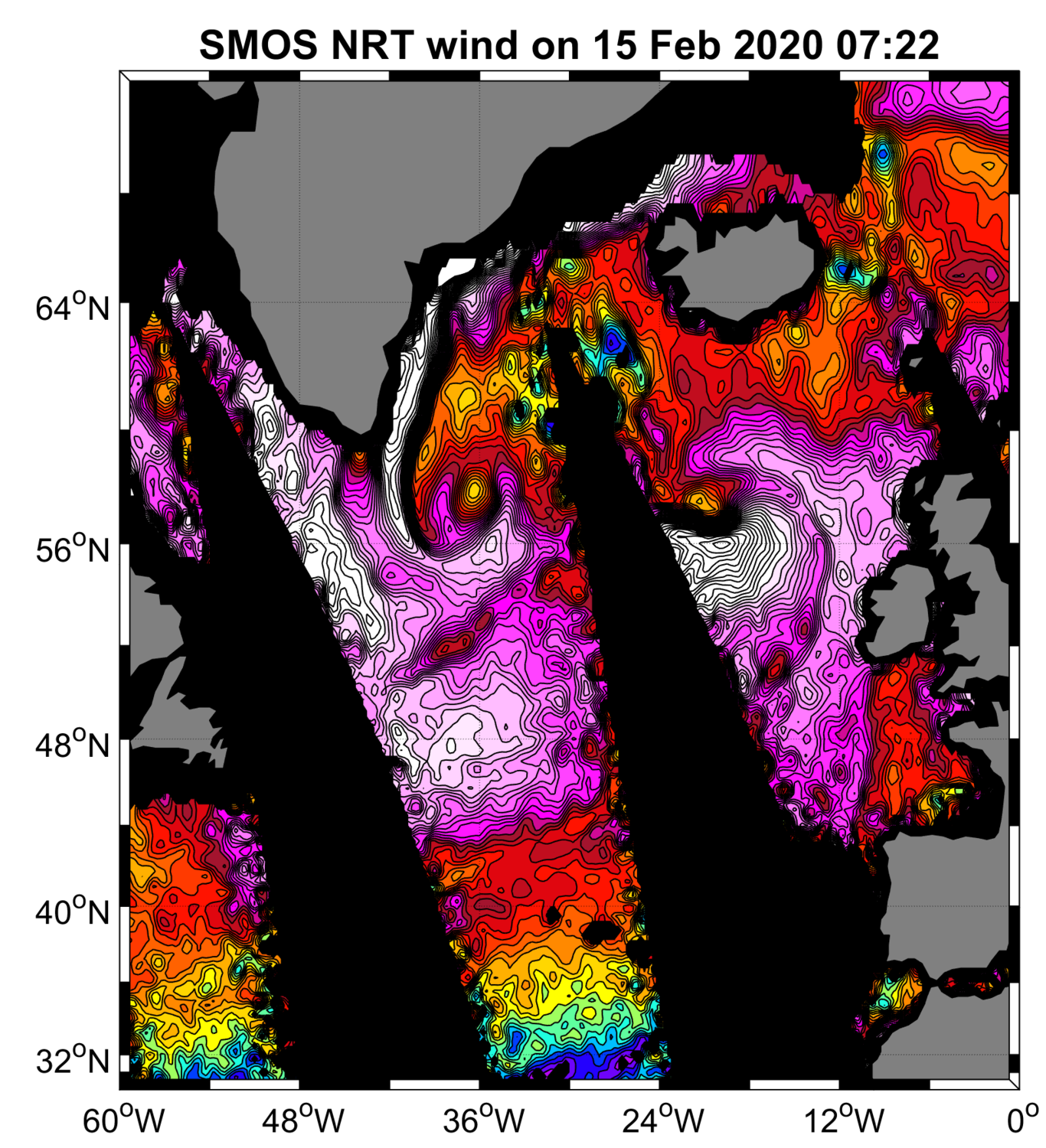
“SMOS Near Real Time Level 2 swath wind speed” (SMOS L2WS NRT) products, which are SMOS retrieved surface wind speed gridded maps with a spatial sampling of 1/4°x 1/4° and consisting of orbital segments (containing parts of ascending and descending half orbits) following the granularity of the SMOS Level 1B near real time (NRT) data products. SMOS L2WS NRT products are available within 4 to 6 hours from sensing and are generated in NetCDF-4 format as described in the "SMOS Wind Data Service Product Description Document" (http://www.smosstorm.org/Document-tools/SMOS-Wind-Data-Service-Documentation).
-

The CDR-derived Wet Tropospheric Correction (WTC) Product V2 is generated from the Level-2+ along-track altimetry products version 2024 (L2P 2024) distributed by AVISO+ (www.aviso.altimetry.fr). It provides a long-term, homogenized estimation of the wet tropospheric correction based on Climate Data Records (CDRs) of atmospheric water vapour combined with high frequencies MWR data. Two independent CDRs datasets are used: - REMSS V7R2 (coverage until 2022) https://www.remss.com/measurements/atmospheric-water-vapor/tpw-1-deg-product/ - HOAPS V5 precursor CDR from EUMETSAT CM SAF (coverage until 2020) HOAPS V4/V5 data available via https://wui.cmsaf.eu Note: the HOAPS V5 precursor is not yet an official CM SAF product; full validation and public release are pending. The MWR/CDR WTC V2 estimates is derived using spatially varying but temporally constant polynomial coefficients (ai). 1. WTC V2 – Along-track L2P Product Data format: The WTC V2 product is delivered in Level-2+ (L2P) format, along the satellite ground track. Each mission is distributed as a compressed archive (.tar.gz) containing one NetCDF4 CF-1.8 file per mission cycle. Archive naming convention: <mission>_WTC_from_WV_CDR_<version>.tar.gz mission: TP (TOPEX/Poseidon), J1, J2, J3 version: product version (currently V2) File naming convention inside archives: <mission>_C<cycle>.nc cycle: 4-digit cycle index (e.g., C0001) Each NetCDF file contains: 1/ Along-track WTC estimate; 2/ Ancillary information; 3/ Space–time coordinates 2. WTC CDR Uncertainties – Gridded Product: A complementary product is provided, delivering regional trend estimates and associated uncertainties from the WTC Climate Data Record. The uncertainty product is distributed as a single NetCDF4 file: wtc_trend_uncertainties.nc . This file contains global gridded fields of WTC CDR trend and uncertainty parameters. Product content: This is the first dedicated version providing both: WTC CDR (HOAPS) linear trends, and Uncertainty estimates on these trends. Uncertainties are expressed as 1-sigma confidence intervals, and propagated using the methodology described in Section 2.3 of the Product User Manual. The product includes: - Total uncertainty on the WTC trend, propagated from all identified uncertainty sources in the WTC–TCWV regression. - Individual contributions of uncertainty sources (Uncertainties on regression coefficients: a0, a1 and their standard deviations; Uncertainties inherited from the HOAPS TCWV CDR) These fields enable users to assess the relative importance of each uncertainty component and recompute uncertainty propagation with alternative methods. Included regression input variables: To ensure transparency and reproducibility, the product provides: 1/ regression coefficients a0, a1; 2/ their associated uncertainties (std of a0, std of a1); 3/additional diagnostic fields required to recompute uncertainties if needed.
-

This dataset contains the high-frequency total horizontal current at 15m depth on a global grid at 1/4° resolution. It is composed by the addition of two components, the first is the Geostrophic current derived by Altimetry, from the DT-2018 CMEMS database, and the second is the unsteady-Ekman ageostrophic component forced by the wind. All the details about the algorithm and the physical content of this ageostrophy component are given in the ATBD. The data are available through HTTP and FTP; access to the data is free and open. This dataset was generated by Datlas Ocean and is distributed by Ifremer / CERSAT in the frame of the World Ocean Circulation (WOC) project funded by the European Space Agency (ESA).
-
Level 3 twice-daily sub-skin Sea Surface Temperature derived from AVHRR on Metop-A, global and re-projected on a 0.05° regular grid, in GHRSST compliant netCDF format. The satellite input data has successively come from Metop-A and Metop-B level 1 data processed at EUMETSAT. SST is retrieved from AVHRR infrared channels (3.7, 10.8 and 12.0 µm) using a multi-spectral algorithm and a cloud mask. Atmospheric profiles of water vapor and temperature from a numerical weather prediction model, Sea Surface Temperature from an analysis, together with a radiative transfer model, are used to correct the multispectral algorithm for regional and seasonal biases due to changing atmospheric conditions.The quality of the products is monitored regularly by daily comparison of the satellite estimates against buoy measurements. The product format is compliant with the GHRSST Data Specification (GDS) version 2. Users are advised to use data only with quality levels 3, 4 and 5.
-

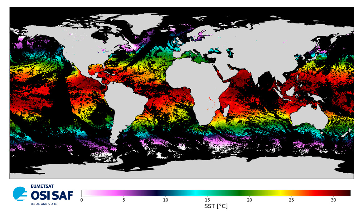
This dataset provide a times series of daily multi-sensor composite fields of Sea Surface Temperature (SST) foundation at high resolution (HR) on a 0.10 x 0.10 degree grid (approximately 10 x 10 km) for the Global Ocean, every 24 hours. Whereas along swath observation data essentially represent the skin or sub-skin SST, the L3S SST product is defined to represent the SST foundation (SSTfnd). SSTfnd is defined within GHRSST as the temperature at the base of the diurnal thermocline. It is so named because it represents the foundation temperature on which the diurnal thermocline develops during the day. SSTfnd changes only gradually along with the upper layer of the ocean, and by definition it is independent of skin SST fluctuations due to wind- and radiation-dependent diurnal stratification or skin layer response. It is therefore updated at intervals of 24 hrs. SSTfnd corresponds to the temperature of the upper mixed layer which is the part of the ocean represented by the top-most layer of grid cells in most numerical ocean models. It is never observed directly by satellites, but it comes closest to being detected by infrared and microwave radiometers during the night, when the previous day's diurnal stratification can be assumed to have decayed. The processing combines the observations of multiple polar orbiting and geostationary satellites, embedding infrared of microwave radiometers. All these sources are intercalibrated with each other before merging. A ranking procedure is used to select the best sensor observation for each grid point. This dataset is generated daily within a 24 delay and is therefore suitable for assimilation into operational models. It is produced in the frame of Copernicus Marine Service and the data available through various tools and protocols with a simple user registration from this service (product identifier: SST_GLO_SST_L3S_NRT_OBSERVATIONS_010_010) at: https://data.marine.copernicus.eu/product/SST_GLO_SST_L3S_NRT_OBSERVATIONS_010_010