 Catalogue PIGMA
Bathymétrie
Type of resources
Available actions
Topics
Keywords
Contact for the resource
Provided by
Years
Formats
Representation types
Update frequencies
status
Scale
Resolution
-

Archives des données de bathymétrie multifaisceaux traitées par le département Dyneco dans le cadre de ses programmes de recherche.
-
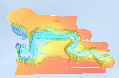
Bathymétrie du canyon de Capbreton (campagne SEDYMAQ3 en 2012), au pas de 2 mètres (projection Mercator latitude conservée 44°N). Ce Modèle Numérique de Terrain est calculé à partir des données acoustiques du sondeur multifaisceau EM2040 du N/O Thalia. Référence verticale: Niveau des plus basses mers astronomiques PBMA (LAT) Description de la campagne : GILLET Hervé (2012) SEDYMAQ3 cruise, RV Thalia, https://doi.org/10.17600/12070080
-
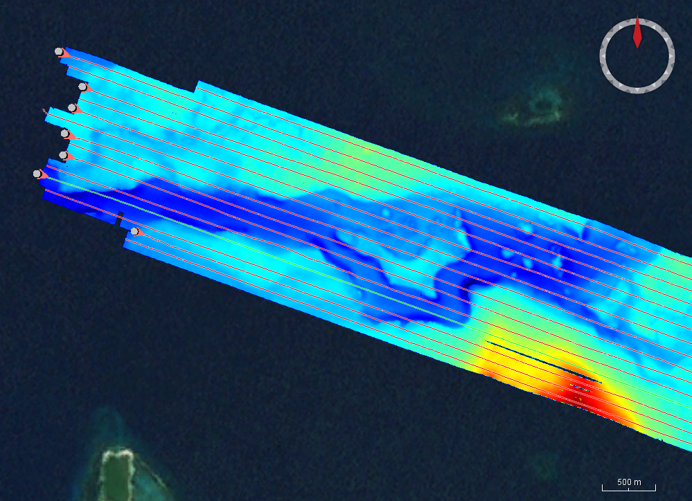
Cette base de données multifaisceaux contrôlée a été initiée au sein de l'Ifremer par l’équipe ANTIPOD de l’UMR Geo-Ocean (6538), en collaboration avec le service SISMER. Elle met à disposition des fichiers de données au format « sondeur multifaisceaux » (.mbg / .xsf) à l’un ou l’autre des deux niveaux de contrôle décrits ci-dessous : • A l’échelle d’une campagne, le contrôle est réalisé de manière globale : épuration de premier ordre des données aberrantes, recherche et corrections de biais global éventuel, rejets de périodes d’acquisition lorsque la qualité des données est jugée insuffisante. Aucune correction locale ou ponctuelle n’est appliquée. A cette échelle, le contrôle vise à préparer les données pour une contribution à des modèles bathymétriques régionaux à moyenne résolution spatiale (50 à 100 mètres). Ces données sont adaptées pour être intégrées à des modèles de type Gebco (https://www.gebco.net/), Seabed2030 (https://seabed2030.org/) ou EMODnet Bathymetry (https://emodnet.ec.europa.eu/en/bathymetry). • A l’échelle des profils d’acquisition : pour les campagnes concernées, l’acquisition des données est découpée en profils (lignes continues d’acquisition sans giration du navire). Le contrôle et la correction des données sont ensuite réalisés profil par profil, plus finement qu’un contrôle global au niveau de la campagne. A cette échelle, le contrôle vise une validation complète des données et leur correction lorsque nécessaire : épuration de données aberrantes, observation et correction de biais ponctuels ou locaux (roulis, célérité…), application d’une correction de marée…Ces données sont adaptées pour le calcul de modèles bathymétriques à la pleine résolution des données acquises. Aucun échantillonnage n’est appliqué aux données.
-

Bathymétrie du canyon de Capbreton (campagne VOLT1 RECUP LEG1, 2016), au pas de 5 mètres (projection Mercator latitude conservée 43°40' nord). Ce Modèle Numérique de Terrain est calculé à partir des données acoustiques du sondeur multifaisceau EM2040 du N/O Thalia. Description de la campagne : SILVA JACINTO Ricardo (2016) VOLT 1 RECUP LEG1 cruise, RV Thalia, https://doi.org/10.17600/16006100
-

Bathymétrie de la partie côtière du canyon de Capbreton (campagne VOLT1 en 2015), au pas de 3 mètres. Ce Modèle Numérique de Terrain est calculé à partir des données acoustiques du sondeur multifaisceau EM2040 du N/O Thalia. Référence verticale : zéro hydrographique (ZH) Description de la campagne : SIMPLET Laure (2015) VOLT 1 cruise, RV Thalia, https://doi.org/10.17600/15003900
-

Ce jeu de données contient, sous forme de polygones, les zones couvertes par les Modèles Numériques de Terrain (MNT) bathymétriques issus des transits valorisés des navires de la flotte océanographique française. L'acquisition est faite par des sondeurs multifaisceaux grands fonds (12kHz), selon un mode opératoire d'opportunité, pendant les transits des bateaux. La résolution horizontale de tous les MNT est de 1 / 8 minute d'arc. Les transits valorisés sont décrits par le DOI : https://doi.org/10.18142/337
-

Bathymétrie du canyon de Capbreton (campagne VOLT1 en 2015), au pas de 5 mètres. Ce Modèle Numérique de Terrain est calculé à partir des données acoustiques du sondeur multifaisceau EM2040 du N/O Thalia. Référence verticale: zéro hydrographique (ZH) Description de la campagne : SIMPLET Laure (2015) VOLT 1 cruise, RV Thalia, https://doi.org/10.17600/15003900
-

Bathymétrie du canyon de Capbreton (campagne VOLT1 RECUP LEG1, 2016), au pas de 2 mètres (projection Mercator latitude conservée 43°40' nord). Ce Modèle Numérique de Terrain est calculé à partir des données acoustiques du sondeur multifaisceau EM2040 du N/O Thalia. Description de la campagne : SILVA JACINTO Ricardo (2016) VOLT 1 RECUP LEG1 cruise, RV Thalia, https://doi.org/10.17600/16006100
-

Ensemble résultant du découpage par zones du chenal de navigation.Ces passes sont régulièrement hydrographiées.
-
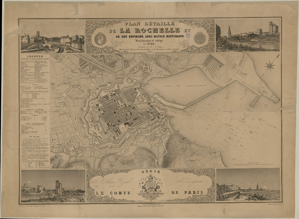
Thème : Date.edition : Auteur.nom : Auteur.date : Interêt : 1844 plan large avec cartouches, Projet extension deuxième bassin à flot. Editeur : Echelle : Taille : Lieu d'archivage : Michel Crépeau, Patrimoine, Reserve A 1 PL 287. Exclu du prêt, consultation sur place Numéro d'archive : Plan Carte (No ) Indices : Référence : 1 PL 287