 Catalogue PIGMA
farming
Type of resources
Available actions
Topics
Keywords
Contact for the resource
Provided by
Years
Formats
Representation types
Update frequencies
status
Scale
Resolution
-

En France et en Europe, des logos officiels permettent de reconnaître des produits qui bénéficient d'un signe officiel de la qualité et de l'origine.
-

Ce document présente une synthèse des travaux effectués par les partenaires du projet FORRISK (Réseau pour l'innovation dans les sylvicultures et les systèmes de gestion intégrée des risques en forêt).
-

Étude du statut juridique des voies et les conditions de leur utilisation. Plan : 1- Classification des voies 2- Voies communales 3- Chemins ruraux 4- Chemins d'exploitation 5- Chemins intérieurs
-
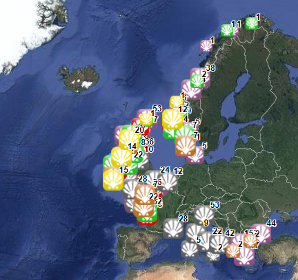
The database on shellfish aquaculture in the EU was created in 2014 by AND-International for the European Marine Observation and Data Network (EMODnet). It is the result of the aggregation and harmonization of datasets provided by national sources across the EU (plus Norway) and by the project Euroshell. Data are available for viewing and download on EMODnet - Human Activities web portal (www.emodnet-humanactivities.eu). The database contains points representing shellfish farms or shellfish production areas (depending on available data) in the following countries: Bulgaria, Denmark, France, Greece, Ireland, Italy, Netherlands, Norway and United Kingdom. Spanish data is provided separately through WMS services. Data is missing for Germany, Portugal, Sweden, Croatia and Slovenia. Except for Germany, the shellfish production remains limited in those MS. There is no production in other MS. Each point has the following attributes (where available): status (active, inactive), country, owner name, farm type (Mussels, Oysters, Mussels-Oysters, Clams, Specialised (other), Mixed (other)), production method (Long lines, Trestles or trays, Tanks, Rafts, Beds, Raceways), production stage (Grow out for human consumption, Hatchery, Nursery, Broodstock, Reproduction, Harvest, Other), purpose (Commercial, Research, Education, Display, Other), species detailed (English translation of the information provided on species grown or authorised in the source), point information (Polygon centroid, Original) depending on how the information is provided in the source (polygons or points), site_id, distance to coast (metres), position from coastline (At sea, within the coastline). The farm type relies on a typology established by AND-International, based on available information on species grown or authorised. A relational table provides harmonised information about species grown or authorised using Eurostat nomenclature for the Species Group (Mussels; Oysters; Clams, cockles, arkshells; Scallops, pectens; Abalones, winkles, conchs; Sea-urchins and other echinoderms) and when available the species name (e.g. Blue mussels - Mytilus edulis). The distance to coast (EEA coastline shapefile) has been calculated using the original data map projections, where available. In the other cases it was used the UTM WGS84 Zone projected coordinate system where data fall in. Compared with the previous version this new version has been not only updated but was also reviewed (dataset schema and attributes values), in order to add information on production methods, production stages and purposes and to provide a more useful typology based on species grown. Data from Norway and Bulgaria have been added. Data from France relies on cadastral data rather than large production areas in the previous database.
-
Aires géographiques des appellations d'origine contrôlées (AOC)/protégées (AOP). Le fichier liste pour chaque commune, identifiée par son département, son nom et son code INSEE, les aires géographiques des appellations AOC/AOP qui se situent sur la commune
-

Potentialités agronomiques par culture (blé, haricot, maïs, orge, tabac et tournesol).
-

Bulletin Sanitaire Végétale: nombre de parcelles à maturité par commune. (métadonnée en cours)
-
Réseau Bienvenue à la ferme (métadonnée en cours)
-
Nombre des détenteurs d'animaux par communes et types d'éleveurs. (métadonnée en cours)
-

Attention : Les données communiquées ici ne le sont qu’à titre informatif. Les délimitations parcellaires officielles sont celles consultables sur les plans déposés en mairie ou auprès des services de l’INAO. A noter également que l’ensemble des délimitations parcellaires des AOC viticoles ne sont pas encore représentées, le travail de dématérialisation étant en cours. Selon les règlements européens 510/2006 du 6 mars 2006 et 1234/2007, le cahier des charges des appellations définit l’aire géographique des produits enregistrés en AOP ou en IGP. Au sein de cette aire est incluse une aire parcellaire correspondant à l’aire de production de la matière première. L'aire parcellaire délimitée correspondant à une délimitation reposant sur les limites administratives du cadastre (les parcelles) et dont le maillage suffisamment fin permet de tenir compte de variations très localisées des éléments du milieu physique. Cette délimitation est utilisée essentiellement pour les AOP et IGP viticoles et correspond dans ce cas à l’aire de production de la matière première. Quelques autres produits en AOP concernent d’autres productions agricoles telles que des huiles d’olives, des noix, des oignons…