 Catalogue PIGMA
ZIP
Type of resources
Available actions
Topics
Keywords
Contact for the resource
Provided by
Years
Formats
Representation types
Update frequencies
status
Scale
Resolution
-
-
-
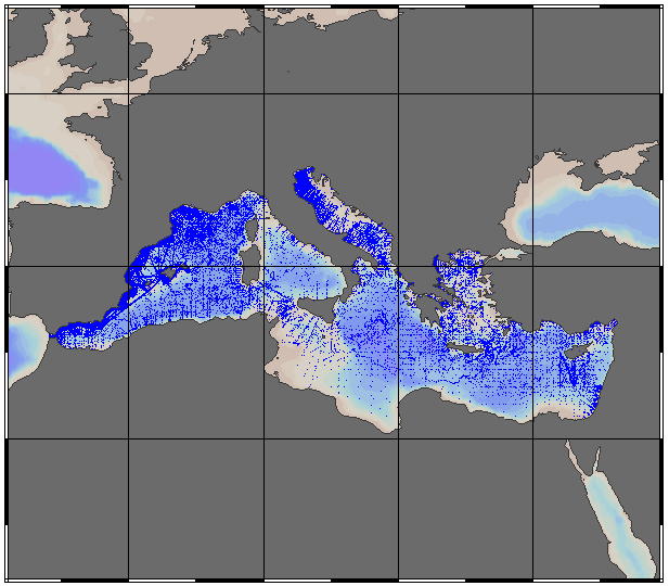
EMODnet Chemistry aims to provide access to marine chemistry data sets and derived data products concerning eutrophication, acidity and contaminants. The chemicals chosen reflect importance to the Marine Strategy Framework Directive (MSFD). ITS-90 water temperature and Water body salinity variables have been also included (as-is) to complete the Eutrophication and Acidity data. If you use these variables for calculations, please refer to SeaDataNet for having the quality flags: https://www.seadatanet.org/Products/Aggregated-datasets . This aggregated dataset contains all unrestricted EMODnet Chemistry data on Eutrophication and Acidity (15 parameters with quality flag indicators), and covers the Mediterranean Sea with 187722 CDI records (180932 Vertical profiles and 6790 Time series). Vertical profiles temporal range is from 1911-08-17 to 2020-10-16. Time series temporal range is from 1974-06-04 to 2018-02-20. Data were aggregated and quality controlled by 'Hellenic Centre for Marine Research, Hellenic National Oceanographic Data Centre (HCMR/HNODC)' from Greece. Regional datasets concerning eutrophication and acidity are automatically harvested and resulting collections are aggregated and quality controlled using ODV Software and following a common methodology for all Sea Regions ( https://doi.org/10.6092/9f75ad8a-ca32-4a72-bf69-167119b2cc12). When not present in original data, Water body nitrate plus nitrite was calculated by summing up the Nitrates and Nitrites. Same procedure was applied for Water body dissolved inorganic nitrogen (DIN) which was calculated by summing up the Nitrates, Nitrites and Ammonium. Parameter names are based on P35, EMODnet Chemistry aggregated parameter names vocabulary, which is available at: https://www.bodc.ac.uk/resources/vocabularies/vocabulary_search/P35/. Detailed documentation is available at: https://dx.doi.org/10.6092/4e85717a-a2c9-454d-ba0d-30b89f742713 Explore and extract data at: https://emodnet-chemistry.webodv.awi.de/eutrophication%3EMediterranean The aggregated dataset can also be downloaded as ODV collection and spreadsheet, which is composed of metadata header followed by tab separated values. This spreadsheet can be imported to ODV Software for visualisation (More information can be found at: https://www.seadatanet.org/Software/ODV ). The original datasets can be searched and downloaded from EMODnet Chemistry Chemistry CDI Data and Discovery Access Service: https://emodnet-chemistry.maris.nl/search
-
-
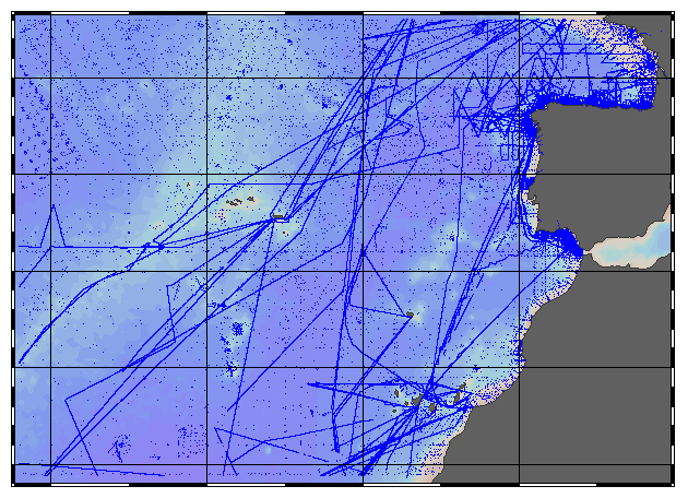
EMODnet Chemistry aims to provide access to marine chemistry data sets and derived data products concerning eutrophication, acidity and contaminants. The chemicals chosen reflect importance to the Marine Strategy Framework Directive (MSFD). ITS-90 water temperature and Water body salinity variables have been also included (as-is) to complete the Eutrophication and Acidity data. If you use these variables for calculations, please refer to SeaDataNet for having the quality flags: https://www.seadatanet.org/Products/Aggregated-datasets. This aggregated dataset contains all unrestricted EMODnet Chemistry data on Eutrophication and Acidity (18 parameters with quality flag indicators), and covers the Northeast Atlantic Ocean (40W) with 381639 CDI records (381085 Vertical profiles and 554 Time series). Vertical profiles temporal range is from 1921-10-15 to 2020-10-16. Time series temporal range is from 1974-06-14 to 2019-04-24. Data were aggregated and quality controlled by 'IFREMER / IDM / SISMER - Scientific Information Systems for the SEA' from France. Regional datasets concerning eutrophication and acidity are automatically harvested and resulting collections are aggregated and quality controlled using ODV Software and following a common methodology for all Sea Regions ( https://doi.org/10.6092/9f75ad8a-ca32-4a72-bf69-167119b2cc12). When not present in original data, Water body nitrate plus nitrite was calculated by summing up the Nitrates and Nitrites. Same procedure was applied for Water body dissolved inorganic nitrogen (DIN) which was calculated by summing up the Nitrates, Nitrites and Ammonium. Parameter names are based on P35, EMODnet Chemistry aggregated parameter names vocabulary, which is available at: https://www.bodc.ac.uk/resources/vocabularies/vocabulary_search/P35/. Detailed documentation is available at: https://dx.doi.org/10.6092/4e85717a-a2c9-454d-ba0d-30b89f742713 Explore and extract data at: https://emodnet-chemistry.webodv.awi.de/eutrophication%3EAtlantic The aggregated dataset can also be downloaded as ODV collection and spreadsheet, which is composed of metadata header followed by tab separated values. This spreadsheet can be imported to ODV Software for visualisation (More information can be found at: https://www.seadatanet.org/Software/ODV ). The original datasets can be searched and downloaded from EMODnet Chemistry Chemistry CDI Data and Discovery Access Service: https://emodnet-chemistry.maris.nl/search
-

Le programme Observation des ventes (ObsVentes) développe un plan d'échantillonnage des apports, sous les criées et à certains points de débarquement, qui répond précisément aux requis du plan de travail national de collecte de données lié au règlement EU-MAP. Il consiste à mesurer périodiquement la taille des individus des principales espèces ciblées par les métiers sélectionnés en tenant compte des appellations commerciales pratiquées sur leurs lieux de vente. L'unité de base ObsVentes est une sortie dans une criée ou sur un lieu de débarquement, pendant une période de temps spécifique au lieu d’échantillonnage (temps pendant lequel les débarquements sont exposés en caisses avant la mise en vente) et pendant laquelle plusieurs ventes, marées et donc navires et métiers peuvent être échantillonnés. Les programmes de collecte de données à terre et en mer sont fondés sur des stratégies d’échantillonnage des navires de pêches de la flottille française stratifiées en métiers. La notion de métier rend compte de l’activité d’un navire à un moment donné, définie par le type d’engin de pêche utilisé, les espèces recherchées (espèces cibles) et la zone de pêche fréquentée. Chacune des strates d’échantillonnage est décrite par un lieu (de pêche ou de débarquement selon le type de collecte) et un type de métier de pêche. La liste des métiers à échantillonner, le nombre d'unités à observer et leur répartition spatio-temporelle constituent le plan d’échantillonnage.
-

Ce jeu de données présente la répartition des aides de la PAC en 2013 par canton au Pays-Basque.
-

Les données d'observation des captures en mer sur les navires professionnels, collectées via le dispositif ObsMer, contiennent : les caractéristiques de la marée et des métiers observés (couple engin-espèce cible), la composition des captures (débarquées et rejetées) en taille et en poids par espèce commerciale et scientifique, les potentielles captures accidentelles. Les données présentées ici ont été spécifiquement extraites pour alimenter les indicateurs d'évaluation de la DCSMM relatifs aux espèces d'amphihalins et d'élasmobranches.
-
Pour les DOM il n’y a que le niveau D (département), pour les autres régions il y a au moins les niveaux D et C (territoires de santé du PRS I), et pour Normandie, Grand Est, Pays de la Loire, Bretagne, Nouvelle-Aquitaine, Auvergne-Rhône-Alpes, il y a les 4 niveaux. Attention aux totaux par année, par région et par niveau, il peut y avoir des écarts entre les niveaux pour chaque région. Le plus souvent c’est à la marge, mais pour Normandie, Grand Est, Nouvelle-Aquitaine c’est plus important (seuls les niveaux D et C donnent le même total régional) du fait que certains regroupements maison fournis par l’ARS n’ont pas été « projetés » par l’INSEE, en raison des contraintes du modèle de projection Omphale 2017.
-

Données présentant l'utilisation agricole du territoire par département et pour les différents types de cultures sur la période 2000-2020. Les surface sont exprimées en hectares.