 Catalogue PIGMA
Celtic Seas
Type of resources
Available actions
Topics
Keywords
Contact for the resource
Provided by
Years
Formats
Representation types
Update frequencies
status
Scale
Resolution
-

Ireland’s Marine Atlas is developed and maintained by the Marine Institute with funding by the Government of Ireland. This work is part supported by the Irish Government and the European Maritime & Fisheries Fund as part of the EMFF Operational Programme for 2014-2020. The atlas provides a one-stop-shop to view and download marine environmental data relevant to reporting under Ireland’s Marine Strategy Framework Directive (MSFD). The aim of the European Union’s MSFD directive is to protect more effectively the marine environment across Europe through the establishment of “good marine waters”. Data in Ireland’s Marine Atlas has been guided by the European Directive on harmonising environmental data across Europe within a spatial data infrastructure known as INSPIRE. INSPIRE Data Specifications (Data Models) have been used to manage data to the categories visible under THEMES in the atlas. Many of the layers displayed in the Atlas are also used in the National Marine Planning Framework (NMPF). This framework aims to bring together all marine-based human activities, outlining the government’s vision, objectives and marine planning policies for each marine activity. The NMPF report details how these marine activities will interact with each other in an ocean space that is under increasing spatial pressure, ensuring the sustainable use of our marine resources to 2040. Please read the following information carefully as it sets out the terms and conditions that govern the use of products and services on this website. Once you have read these terms and conditions click the "Agree" button at the bottom of the page to proceed. By clicking the "Agree" button you will be deemed to have accepted the terms and conditions, our legal notices and privacy statement.
-
Excel file containing CPR data from Standard Areas B4,C3,C4,D3,D4,D5,E4,F4 for the plankton Calanus finmarchicus and helgolandicus, total traverse (small) copepods, total large copepods, Phytoplankton Colour Index and Cnidaria (presence denoted by a 1, absence by a zero). All taxa are from 1980, except Cnidaria which are from 2011. Dataset is in the format of sample level data, with each row being a discrete sample, with a sample being 3m3 filtered seawater, and 10nm of tow. For each row, a sample has the following information, starting at column a: Standard area of sample, sample id, latitude (decimal degrees) of sample mid point, longitude (decimal degrees) of sample midpoint, sample midpoint date and local time, year of sample, month of sample, then plankton abundance values (or PCI index or cnidaria presence/absence). All taxa have been looked for during the period this dataset spans, so zero values represent true absence.
-

This is a compilation of OSPAR habitat point data for the northeast Atlantic submitted by OSPAR contracting parties. The compilation is coordinated by the UK's Joint Nature Conservation Committee, working with a representative from each of the OSPAR coastal contracting parties. This public dataset does not contain records relating to sensitive species (e.g. Ostrea edulis) in specific areas, or where data are restricted from public release by the owner's use limitations. This version (v2020) was published in July 2021.
-

NCAR was established by the National Science Foundation in 1960 to provide the university community with world-class facilities and services that were beyond the reach of any individual institution. More than a half-century later, we are still delivering on that mission. NCAR provides the atmospheric and related Earth system science community with state-of-the-art resources, including supercomputers, research aircraft, sophisticated computer models, and extensive data sets. From its founding, NCAR was meant to provide the atmospheric research community with the shared resources necessary to work on the most important scientific problems of the day. Not much has changed. The hundreds of scientists who work here research all things atmospheric — which includes everything from the microphysics of cloud formation and the chemistry of air pollution to large-scale planetary waves and the impact of increased greenhouse gases on our climate. Since the atmosphere interacts with everything it touches, its crucial to investigate those interactions, too.
-
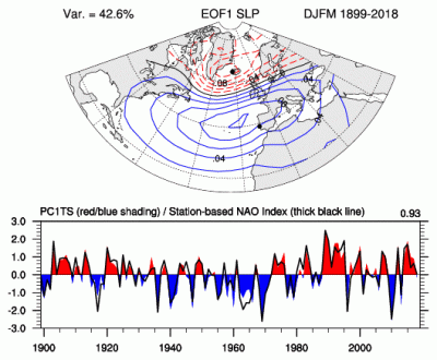
The principal component (PC)-based indices of the North Atlantic Oscillation (NAO) are the time series of the leading Empirical Orthogonal Function (EOF) of SLP anomalies over the Atlantic sector, 20°-80°N, 90°W-40°E. These indices are used to measure the NAO throughout the year, tracking the seasonal movements of the Icelandic low and Azores high. These movements are illustrated in the Figures on this page. Positive values of the NAO index are typically associated with stronger-than-average westerlies over the middle latitudes, more intense weather systems over the North Atlantic and wetter/milder weather over western Europe.
-

The Plankton Lifeform Extraction Tool brings together disparate European plankton datasets into a central database from which it extracts abundance time series of plankton functional groups, called “lifeforms”, according to shared biological traits. This tool has been designed to make complex plankton datasets accessible and meaningful for policy, public interest, and scientific discovery. The Plankton Lifeform Extraction Tool currently integrates 155 000 samples, containing over 44 million plankton records, from nine different plankton datasets within UK and European seas, collected between 1924 and 2017. Additional datasets can be added, and time series can be updated.
-
Intermediate Assessment 2017 - Seabed Litter - Litter is widespread on the seafloor across the area assessed, with plastic being the predominant material encountered. In the areas assessed, higher amounts of litter are found in the Eastern Bay of Biscay, Southern Celtic Seas and English Channel relative to the north of the Greater North Sea and Celtic Seas.
-
Seabed Habitats was one of seven themes of the European Marine Observation and Data Network (EMODnet) initiative, funded by the European Maritime and Fisheries Fund. Since its inception in 2009, EMODnet Seabed Habitats developed, improved and gradually increased the coverage of a broad-scale seabed habitat map for Europe's seabed, also known as EUSeaMap. In addition, EMODnet Seabed Habitats continued the work started by MESH and MESH Atlantic projects in collating and making available seabed habitat maps from surveys, through the EMODnet Seabed Habitats map viewer. In it's third Phase (2017-2019), EMODnet Seabed Habitats collated and provided habitat point data and the outputs of habitat distribution modelling, and the third phase has now been extended to 2021. The extended third phase of the project will: - Continue to grow Europe's only comprehensive library of habitat maps from surveys and collection of survey sample points - Create new composite data products to add to those for the Essential Ocean Variable habitats and OSPAR threatened and/or declining habitats - Update the EMODnet broad-scale seabed habitat map for Europe (EUSeaMap) using the next seabed substrate update from EMODnet Geology - Update web content with extra resources for habitat mapping, including a catalogue highlighting all the most useful data products
-

MISSION ATLANTIC assesses the whole Atlantic, and ecosystem components at risk from natural hazards and the consequences of human activities, including individual regional Case Studies, and their interconnectivity. To do this, Mission Atlantic develops IEAs for seven regional Case Studies, in sub-Arctic and Tropical regions of the Atlantic Ocean, ranging from shelf seas to the mid-Atlantic Ridge: 1) Norwegian Sea 2) Celtic Sea 3) Canary Current 4) North Mid Atlantic Ridge 5) South Mid Atlantic Ridge 6) Benguela Current 7) South Brazilian Shelf
-
The Continuous Plankton Recorder (CPR) Survey is the most geographically extensive marine monitoring programme in the world. Today the Survey is operated by the Marine Biological Association, based in Plymouth, UK. Operating since 1931, the Continuous Plankton Recorder (CPR) survey is recognised as the longest sustained and geographically most extensive marine biological survey in the world. The dataset comprises a uniquely large record of marine biodiversity covering ~800 taxa over multi-decadal periods. In terms of our scientific understanding of natural variability and human-induced change on our oceans, the CPR survey is of global importance and it is used by scientists, policy makers and environmental managers across the world. The data is used to examine strategically important science pillars such as climate change, human health, fisheries, biodiversity, pathogens, invasive species, ocean acidification and natural capital. The results have included the globally first documented studies of large-scale ecological regime shifts, and of biogeographic, phenological and trans-arctic migrations in the marine environment in response to climate change. The data in this sampling event resource has been published as a Darwin Core Archive (DwC-A), which is a standardized format for sharing biodiversity data as a set of one or more data tables. The core data table contains 252,385 records. 2 extension data tables also exist. An extension record supplies extra information about a core record. The number of records in each extension data table is illustrated below.