Catalogue PIGMA
Pigments
Type of resources
Available actions
Topics
Keywords
Contact for the resource
Provided by
Years
Formats
Representation types
Update frequencies
status
Scale
Resolution
-
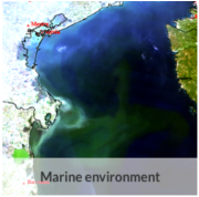
For the 21 years of the study, an examination of trends in chlorophyll concentration revealed a general decline throughout the Gulf over the production period. These trends, extracted from dynamic linear model, also allowed this decline to be quantified. Expressed as a percentage, a large part of the area below the 50 m bathymetric line showed a decrease of at least 10% over the period, corresponding to a value of at least 0.1 µg.l-1. However, the spatial distribution reveals some more local phenomena. In southern Brittany, from Quimper to Vannes, a particular feature appears, with an upward trend over several kilometres along the coast, followed by a pronounced gradient along the coast. This gradient includes a zone where a continuous monotonic increasing trend is observed, then a zone where the trend becomes not significant and finally, about 15 km from the coast, a new zone where a significant continuous monotonic decreasing trend is observed. The increase in chlorophyll a concentration in the very coastal part is greater than 0.1 µg.l-1 over the period. Another peculiarity concerns the central part, located at the edge of the plateau at Cap Ferrat and Pente Aquitaine, where an increase in chlorophyll a was observed, but the variations remained small, being less than 0.1 µg.l-1. About a hundred kilometres south-west of Saint Nazaire, an area of about 40 by 50 km shows a decrease in chlorophyll a of more than 20%, quantified as more than 0.1 µg.l-1 over the period.
-

This dataset provides a global Look-Up Table (LUT) of physiological ratios for the real-time adjustment of chlorophyll-a fluorescence measured by biogeochemical Argo (BGC-Argo) profiling floats. The physiological ratios aim to account for the global variability in the relationship between fluorescence and chlorophyll-a concentration, as influenced by phytoplankton physiology. The LUT was developed using two different gap-filled observational Argo-based products (SOCA machine learning-based methodology ; Sauzède et al., 2016; Sauzède et al., 2024). The first product provides gap-filled chlorophyll-a data derived from fluorescence corrected for dark signal and non-photochemical quenching (NPQ) following Schmechtig et al. (2023), while the second product provides chlorophyll-a concentrations derived from light attenuation. The latter is based on the downward irradiance at 490 nm (ED490) derived from the SOCA-light method (Renosh et al., 2023). From this, the diffuse attenuation coefficient (KD490) is computed, which is subsequently used to estimate the chlorophyll-a concentration through the bio-optical relationships described by Morel et al. (2007). These two products, based on fluorescence and radiometry, enable the derivation of spatially varying correction factors, or physiological ratios. These ratios provide a validated grounded framework for adjusting real-time fluorescence observations from OneArgo floats into chlorophyll-a concentrations. The LUT is distributed in NetCDF format and is provided on a regular 1°×1° latitude–longitude grid covering the global ocean. Each grid cell contains the temporal mean, averaged over the water column (from the surface to 1.5 times the euphotic depth), of the physiological ratio. The file also includes metadata describing variable definitions, units, and other relevant information. Variables included: - physiological_ratio — fluorescence-to-radiometry-based chlorophyll correction factor (dimensionless) - physiological_ratio_sd — temporal standard deviation (over the twelve months) of the fluorescence-to-radiometry-based chlorophyll correction factor (dimensionless) - lat, lon — spatial coordinates (degrees north/east) - Global attributes — dataset description, reference citation, and contact information
-
This In Situ delayed mode product integrates the best available version of in situ oxygen, chlorophyll / fluorescence and nutrients data. The latest version of Copernicus delayed-mode BGC (bio-geo-chemical) product is also distributed from Copernicus Marine catalogue.
-

This dataset contains the biological outputs of a global ocean simulation coupling dynamics and biogeochemistry at ¼° over the year 2019. The simulation has been performed using the coupled circulation/ecosystem model NEMO/PISCES (https://www.nemo-ocean.eu/), which is here enhanced to perform an ensemble simulation with explicit simulation of modeling uncertainties in the physics and in the biogeochemistry. This dataset is one of the 40 members of the ensemble simulation. This study was part of the Horizon Europe project SEAMLESS (https://seamlessproject.org/Home.html), with the general objective of improving the analysis and forecast of ecosystem indicators. See Popov et al. (https://os.copernicus.org/articles/20/155/2024/) for more details on the study.
-
-
-

Coastal Surveillance Through Observation of Ocean Color (COASTlOOC) oceanographic expeditions were conducted in 1997 and 1998 to examine the relationship between the optical properties of seawater and related biological and chemical properties across the coastal-to-open ocean gradient in various European seas. A total of 379 stations were visited along the coasts of the Gulf of Lion in the Mediterranean Sea (n = 61), Adriatic Sea (n = 39), Baltic Sea (n = 57), North Sea (n = 99), English Channel (n = 85) and Atlantic Ocean (n = 38). Particular emphasis was dedicated to the collection of a comprehensive set of apparent (AOPs) and inherent (IOPs) optical properties to support the development of ocean color remote sensing algorithms. The data were collected in situ using traditional ship-based sampling, but also from a helicopter, which is a very efficient means for that type of coastal sampling. The dataset collected during the COASTlOOC campaigns is unique in that it is fully consistent in terms of operators, protocols, and instrumentation. This rich and historical dataset is still today frequently requested and used by other researchers. Therefore, we present the result of an effort to compile and standardize a dataset which will facilitate its use in future development and evaluation of new bio-optical models adapted for optically-complex waters.
-
This dataset contains bio-optical measurements and environmental parameters associated with Deep Chlorophyll Maxima acquired by BGC-Argo profiling floats and matched with mesoscale eddies location from the Ocean Eddy Detection and Tracking Algorithms (TOEeddies) Atlas. For each BGC-Argo profile the data files includes the World Meteorological Organistion (WMO) and profile numbers, geographical position (LON and LAT), the date of the profile in Julian Day (JULD); the qualification of the vertical profile (CARAC_BIO) as Deep Biomass Maximum (DBM), Deep photoAcclimation Maximum (DAM), or presenting no DCM (NO); at the depth of the maximum (DCM_DEPTH), the chlorophyll a concentration (CHLA_DCM, mg chla m-3 ) and the backscattering coefficient (BBP_DCM, m-1); the Mixed Layer Depth (MLD, m), the nitracline depth (NCLINE, m), the mean daily Available PAR in the Mixed Layer Depth (MIPAR_MLD, E m -1 d -1), the daily Available PAR at the nitracline depth (IPAR_NCLINE, E m-2 d-1); the location of the profile (CARAC_EDDY) as being inside the core/periphery (IN/_EN) of a cyclonic/anticyclonic eddy (DEP_/P_), or outside eddy influence (OUT); the processing level (MODE) of the ADT maps used for the TOEddies detection, either Near Real Time (-1), or Delayed Mode (1). The qualification and processing of the BGC-Argo profiles, as well as the DCM detection (DAM/DBM/NO) and the estimation of the environmental parameters, were applied as described from Cornec, M., Claustre, H., Mignot, A., Guidi, L., Lacour, L., Poteau, A., D'Ortenzio, F., Gentili, B., Schmechtig, C. (2021). Deep chlorophyll maxima in the global ocean: Occurrences, drivers and characteristics. Global Biogeochem Cycles 35. https://doi.org/10.1029/2020GB006759 Data relative to mesoscale eddies were produced by processing daily 0.25°x0.25° AVISO Absolute Dynamical Topography (maps produced by Ssalto/Duacs and distributed by Copernicus-Marine Environment Services) with the TOEddies algorithm (Laxenaire, R., Speich, S., Blanke, B., Chaigneau, A., Pegliasco, C., & Stegner, A. (2018). Anticyclonic Eddies Connecting the Western Boundaries of Indian and Atlantic Oceans. Journal of Geophysical Research: Oceans, 123(11), 7651–7677. https://doi.org/10.1029/2018JC014270)
-

-