 Catalogue PIGMA
Structure
Type of resources
Available actions
Topics
Keywords
Contact for the resource
Provided by
Years
Formats
Representation types
Update frequencies
status
Scale
Resolution
-

Cette donnée représente l'ensemble des ERP géolocalisés du Lot-et-Garonne. Le périmètre de production concerne les ERP de catégories 1, 2, 3, 4, et 5 avec local à sommeil soit 1069 ERP. Seuls les ERP de catégorie 5 sans local à sommeil ne sont pas classés. Tous les types d'ERP sont représentés sauf les ERP type CTS. Etant donné les changements fréquents dont les ERP sont sujets, la mise à jour de ces données ne peut être permanente.
-

Cette donnée représente l'ensemble des ERP géolocalisés de la Gironde. Le périmètre de production concerne les ERP de type J,O,Uh et Rh, soit 1066.
-

Remontées mécaniques des stations Pyrénées-Atlantiques
-
This dataset stems from the Joint Research Centre (JRC) Biomass Mandate (https://knowledge4policy.ec.europa.eu/projects-activities/jrc-biomass-mandate_en) and it is available for viewing and download on EMODnet - Human Activities web portal (www.emodnet-humanactivities.eu) and on the platform from the European Commission’s Knowledge Centre for Bioeconomy (https://knowledge4policy.ec.europa.eu/visualisation/bioeconomy-different-countries_en#algae_prod_plants). Its aim is to build a reliable database to characterize the algae sector and to support informed European policies on Blue Growth and Bioeconomy. More detailed information on the Status of the Algae Production Industry in Europe can be found in a JRC-led study published in Frontiers in Marine Science (https://publications.jrc.ec.europa.eu/repository/handle/JRC122250). Information on the location (geographic coordinates) of the production facilities, group of produced organism (macroalgae, microalgae and spirulina), production method (Fermenters, Harvesting , Photobioreactors, Open ponds, Semi Open ponds, land-based or at sea Aquaculture, Integrated multi-trophic or not) and species (see dataset) have been collected in the following countries: Austria, Belgium, Bulgaria, Croatia, Czech Republic, Denmark, Estonia, Faroe Islands, France, Germany, Greece, Greenland, Hungary, Iceland, Ireland, Italy, Latvia, the Netherlands, Norway, Portugal, Spain, Sweden, Switzerland and the UK. In November 2021, the JRC has updated the database with the latest information on the production units operational at the time.
-

Liste des logements sociaux issue du Répertoire du parc locatif des bailleurs sociaux (RPLS) sur l'Aquitaine. Millésime 2013
-
Évolution de l'urbanisation ( DÉFINITION )au Nord du PNR des Landes de Gascogne entre 2009 et 2014. Analyse de l'urbanisation en fonction des routes primaires et secondaires. Zone d'étude : Le Barp, Mios et Marcheprime. Jeu de données : - "Bâti indifférencié" et "bâti industriel": BD Topo 2009 et BD Topo 2014 - "Routes primaires" et "Routes secondaires" : BD Topo 2009 - Limites des communes : GEOFLA
-
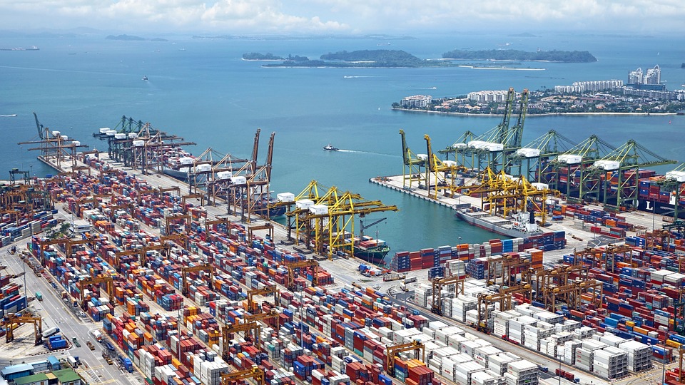
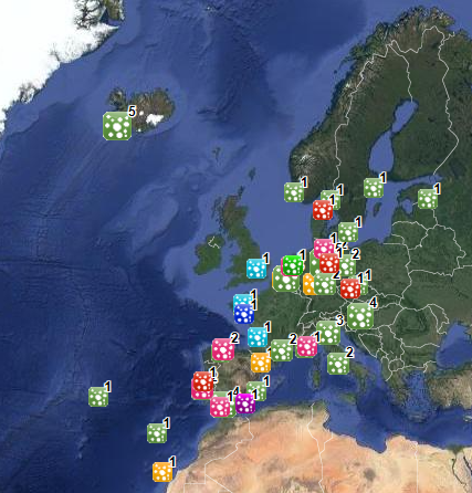
World list of seaports. In its 2021 version, the repository includes 13709 ports for 187 countries. The list of seaports has been drawn up on the basis of the information available in the European reference system of places used in the framework of the Common Fisheries Policy and, more particularly, by the Electronic Recording and Reporting System (ERS), the list of ports identified by the UNECE (2021-1). An assessment of the infrastructures present along the coastline made it possible to identify other ports that were not listed. Each geographical position has been verified with Google Earth in WGS84. Each port is associated with information relating to the country (ISO 3 coding), the UNECE or ERS 5-character coding, the name, the geographical position in WGS84 (latitude and longitude), the status of the port indicating whether it is referenced by Unece (UNECE), by the EU/ERS (ERS) or by both (UNECE/ERS) In case the port is not referenced by UNECE or ERS, the status is N/A. For French ports, the reference system integrates the ports of the French overseas departments and territories with the national codification. Inland ports have also been integrated in 2021.
-

Cette donnée est constituée des couches suivantes sur ensemble du département des Landes : - immeubles protégés au titre des Monuments Historiques servant de base aux périmètres légaux, - emprise des périmètres de 500 mètres et des Périmètres de Protection Modifiés représentant l'emprise des servitudes légales autour des Monuments Historiques , - Zones de Protection du Patrimoine Architecture Urbain et Paysagé (ZPPAUP) - Sites classés : monument ou espace naturel remarquable et exceptionnel par le caractère artistique, historique, scientifique, légendaire ou pittoresque, rigoureusement protégé. - Sites inscrits : monument ou espace naturel remarquable et exceptionnel par son caractère artistique, historique, scientifique, légendaire ou pittoresque, avec suffisamment d’intérêt pour que son évolution soit suivie de près. Ces servitudes d’utilité publique sont opposables aux tiers et reportées dans les documents d’urbanisme.
-
Ouvrages d'art gérés par le Département de Charente-Maritime. Cette donnée est moissonnée quotidiennement à partir de : https://www.data.gouv.fr/fr/datasets/ouvrages-dart-geres-par-le-departement-charente-maritime/ mots clés : OA, ouvrage d'art, CD17
-

Inventaire des petits éléments patrimoniaux du Pays Marennes Oléron