 Catalogue PIGMA
Habitats and biotopes
Type of resources
Available actions
Topics
Keywords
Contact for the resource
Provided by
Years
Formats
Representation types
Update frequencies
status
Scale
Resolution
-
This study aims to compare different metabarcoding sequences of commercially fished shrimps collected by tree counties on the North Brazil Shelf Large Marine Ecosystem
-

Vibrio bacteria sampled from juvenile oysters and seawater collected in Thau Lagoon (Languedoc-Roussillon, France) in October 2015 during a mortality event were genotyped using hsp60, rctB, topA and mreB protein-coding genes
-

Raw reads for the assembly of Gambusia holbrooki genome.
-

Dart Seq data gathered on Blue Shark in the framework of the PSTBS-IO project supported by funding from FAO, CSIRO Oceans and Atmosphere, AZTI Tecnalia, Institut de recherche pour le développement (IRD), and Research Institute for Tuna Fisheries (RITF) and financial assistance of the European Union (GCP/INT/233/EC – Population structure of IOTC species in the Indian Ocean), and POPSIZE project supported by FEAMP (2014-2020 UE N°508/2014), and Institut français de recherche pour l'Exploitation de la mer (Ifremer).
-
The present data set concerne metabarcoding raw reads produced using 4 different PCR targeting polymerase or capside coding region of the genoyupe I and II of norovirus. Test samples of norovirus with serial dilutions in pure water and after a bio-accumulation in oysters. Sequencing was made after VirCapSeq-VERT approach.
-
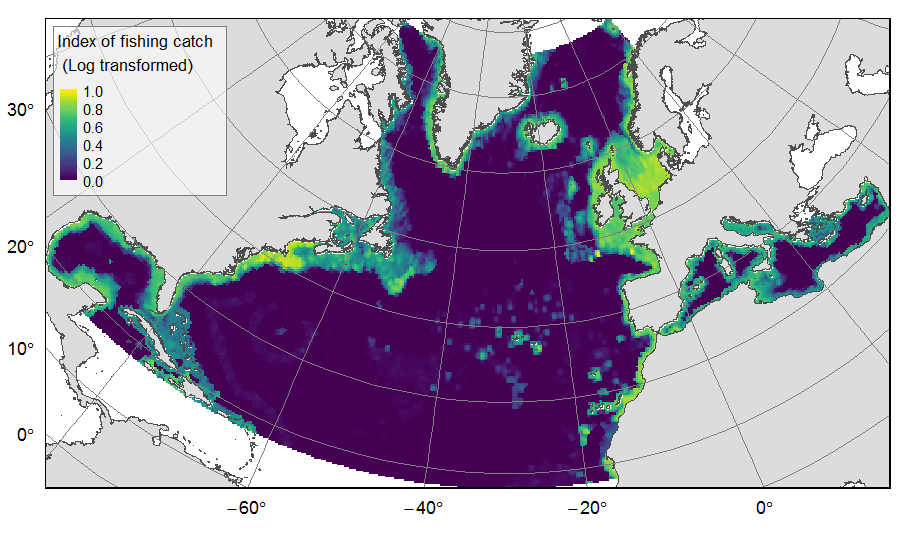
Distribution of catch from deep-sea impacting fishing on the North Atlantic (18°N to 76°N and 36°E to 98°W), for the period 2010-2015. The average of yearly fishing catch for the period 2010-2015 is displayed as an index on the ATLAS grid of 25km * 25km resolution. Source data originated from the Global Fisheries Landings V4.0 database. The dataset was filtered to select only the fishing gears that have an impact on large areas of the seafloor (dredges, bottom trawls, and Danish seines). Within each cell, all remaining catch records were summed to get the total catch rate of the considered year. This dataset was built to feed a basin-wide spatial conservation planning exercise, targeting the deep sea of the North Atlantic. The goal of this approach was to identify conservation priority areas for Vulnerable Marine Ecosystems (VMEs) and deep fish species, based on the distribution of species and habitats, human activities and current spatial management.
-

The eleven collected wild strains of T. lutea were compared phenotypically, in particular with regard to their pigment and lipid profiles. The genome of each T. lutea strain was also sequenced to investigate the genetic structure and genome organisation of this species. Collected data were summarized in a genome browser to provide easy-to-use support for the scientific community (https://genomes-catalog.ifremer.fr). This provides an important resource- to understand, exploit and predict the biodiversity of this species.
-
scRNA-seq reads from a Pacific oyster (Crassostrea gigas) hemocyte preparation. Hemocytes were isolated from a unique immunologically naive animal (Ifremer Standardized Animal, 18 months) and single-cell drop-seq technology was applied to 3,000 individual hemocytes.
-

Develop parentage assignment panels using genetic fingerprinting of pearl oysters for use in commercial hatcheries and research to manage pedigrees in order to limit the risks of loss of genetic variability and increased inbreeding of commercial lines.
-

DNA sequencing of Crassostrea gigas Pacific oyster spat infected in the wild with OsHV-1 virus in 4 French oyster basins (Marennes Oleron Bay, Arcachon bay, Rade de Brest and Thau lagoon).