 Catalogue PIGMA
France
Type of resources
Available actions
Topics
Keywords
Contact for the resource
Provided by
Years
Formats
Representation types
Update frequencies
status
Service types
Scale
Resolution
-
Auteur(s): Parent Pierre , L'auteur étudie les différentes conceptions et formes architecturales qui ont prévalu, après guerre, en matière de logement social, en les replaçant dans leur contexte socio-économique et idéologique. L'analyse critique qu'il en fait, le conduit à chercher et à proposer une solution alternative à celles issues du Mouvement moderne, jugées trop réductrices. Pour l'auteur, la fiabilité du logement social suppose la prise en compte de la complexité urbaine et implique son intégration au coeur même de la ville.
-
Auteur(s): Delanne Hubert-Alexandre , Dans une première partie, l'auteur témoigne de sa sensibilité à la question du développement durable et à ses incidences dans le domaine de l'architecture, par l'intermédiaire de la norme HQE (Haute Qualité Environnementale). Dans cette perspective, il développe, ensuite, une analyse critique de l'évolution du logement social en France, et présente l'idée d'habitat intermédiaire, comme solution de compromis entre les aspirations individualistes d'une part, et la nécessité de lutter contre l'étalement urbain, d'autre part. Le quartier Vigon, à Mimizan (Landes), lui semble propice à une expérimentation de cette forme d'habitat, dans le souci de s'adapter à la diversité des modes de vie de ses occupants, tout en préservant une densité urbaine suffisante et en intégrant, dans la construction, les principes de la HQE.
-
Découpage administratif de la France au niveau communal pour chaque département. 1 fichier vxf représentant 1 département représenté au niveau communal
-
Découpage administratif de la France au niveau département
-
Découpage administratif de la France au niveau régional
-
Découpage administratif de la France au niveau communal pour chaque département. 1 fichier vxf représentant 1 département représenté au niveau communal
-
Découpage administratif de la France au niveau communal par départements
-
Découpage administratif de la France au niveau communal
-
The dataset includes age- and length-based catch per unit effort data for commercial fish species collected by the French trawl survey EVHOE.
-

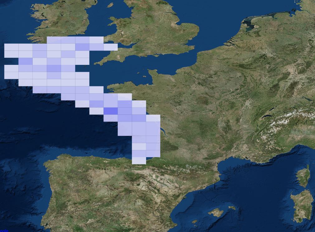
Impulsive or transient sounds of short duration and of high intensity constitute one of the criteria for defining good ecological status for descriptor 11 relating to the pressure of noise generated by human activities within the framework of the MSFD (D11C1). Good ecological status for sound energy is achieved when the risks of acoustic disturbance, excess mortality from sound exposure and reduction in communication distances of mysticetes are cumulatively low or moderate. For this, the spatial distribution, the temporal extent and the acoustic levels of the sources of anthropogenic impulsive sound must not exceed the levels harmful to the populations of marine animals. These criteria are evaluated at the scale of the marine sub-region for the “English Channel and North Sea”, “Celtic Seas” and “Western Mediterranean” regions; and at the scale of the "North" and "South" subdivisions in the "Bay of Biscay" sub-region. One of the indicators selected for the evaluation of criterion D11C1 is the distribution of the acoustic levels of impulsive emissions (D11C1.3). The pressures considered for the evaluation of the criterion are: acoustic emissions from air guns ; acoustic emissions from impulsive sources other than air guns ; emissions from non-impulsive (transient) sources ; underwater explosions ; emissions due to pile driving. The data used for the calculation of this indicator are declarative emissions data traced by the operators of the activities generating impulsive noise.